Object-Based Access Control for Map Data

a technology of object-based access control and map data, which is applied in the field of access control of geographic data, can solve the problems of not being able to add such data, or control and grant access to other data, and achieve the effect of reducing the risk of data loss

Inactive Publication Date: 2012-09-27
GOOGLE LLC
View PDF3 Cites 16 Cited by
  • Summary
  • Abstract
  • Description
  • Claims
  • Application Information

AI Technical Summary

Benefits of technology

[0006]Embodiments relate to access control for geographic data on a per-object basis. A method for securing geographic data over a network is disclosed. The method includes receiving a request to access a geographic data over a network. The request includes an authentication token. A geographic data project associated with the requested geographic data object is identifie

Problems solved by technology

However, if the user wishes to include other data in her map, such as data obtained from a government agency, she ma

Method used


Image

  • Object-Based Access Control for Map Data
  • Object-Based Access Control for Map Data
  • Object-Based Access Control for Map Data

Examples


Embodiment Construction

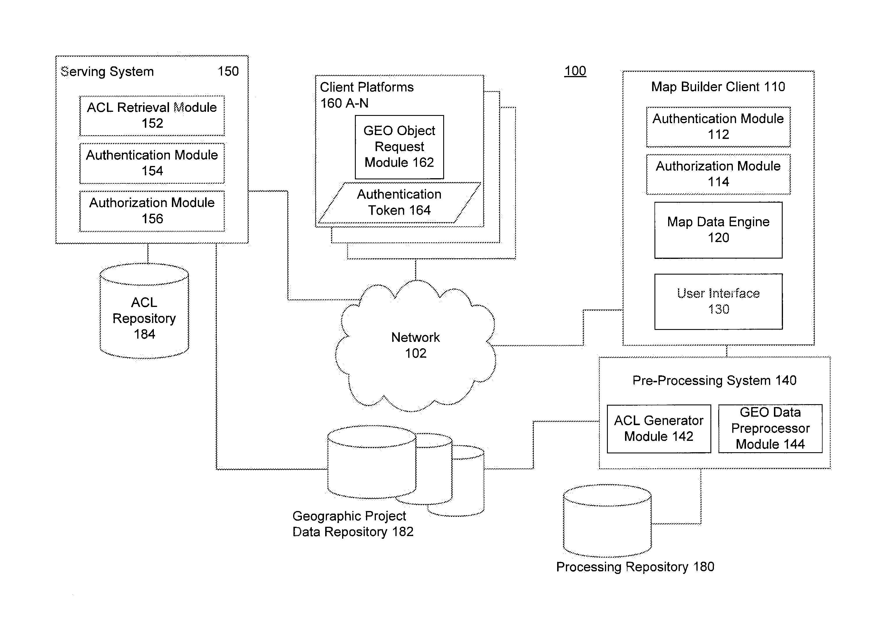
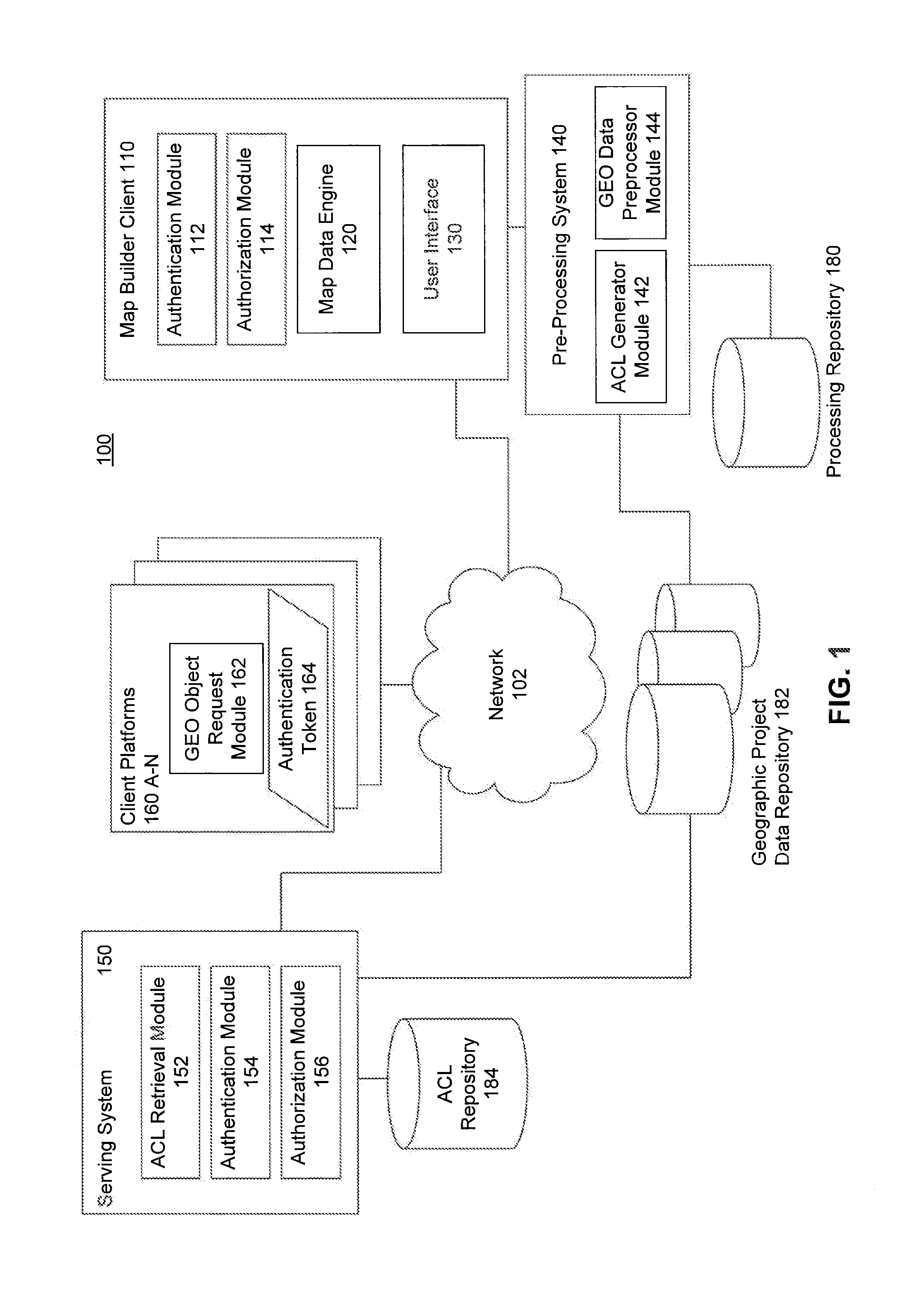
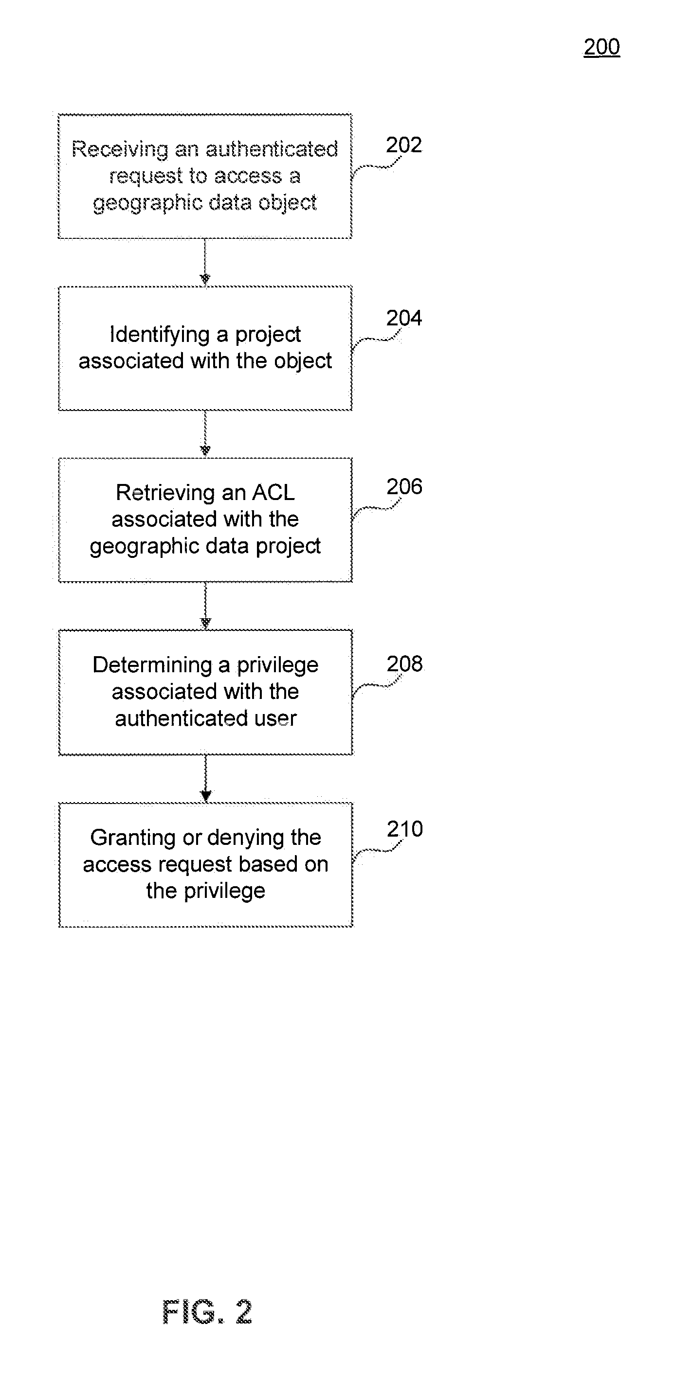
[0015]Embodiments authorize requests for map data on a per-object basis. In an example, a client may send a plurality of requests for map data to display within a view frustum. The map data may include a layer with a plurality of assets. Each of the respective requests are authenticated by the access control filter. Once the requests are authenticated, the access control filter may determine whether a user is authorized to view the data requested. The authorization may be determined based on whether the user is in a group authorized to view the map data. Similarly, a request may be authorized to edit map data or an access control list. In this way, embodiments provide request-based access control and data sharing.

[0016]Access rights are provided for users of geographic information systems software. Access may be controlled on the administrative and map builder sides as well as named access control to a separate unique ID (such as a Google Account name) may be provided. The named acc...


PUM


Abstract

Embodiments allow access to geographic data objects on a per-object basis. A client may send a plurality of requests for geographic data to display within a view frustum. Map data may include a layer with a plurality of assets. Each request may be authenticated by an access control filter, which determines whether the user is authorized to view the data requested.

Description

CROSS REFERENCE TO RELATED APPLICATIONS[0001]This application claims the benefit of U.S. Provisional Appl. No. 61 / 445,883 filed Feb. 23, 2011, which is hereby incorporated by reference in its entirety.BACKGROUND[0002]1. Field[0003]Embodiments generally relate to access control of geographic data.[0004]2. Background[0005]Geographic project data may be subject to various levels of access control. For example, a user may create a map with a list of locations to be shared with others, using My Maps by Google Inc. of Mountain View, Calif. The user may choose to allow others to read or edit the created data. However, if the user wishes to include other data in her map, such as data obtained from a government agency, she may not be able to add such data, or control and grant access to the other data, if she does not have proper authority.BRIEF SUMMARY[0006]Embodiments relate to access control for geographic data on a per-object basis. A method for securing geographic data over a network is...

Claims


Application Information

Patent Timeline
IPC IPC(8): G06F21/20
CPCG06F21/6218G06F2221/2141G06F21/6245G06F16/29
Inventor BROWN, THOMAS DANIELWHEELER, MARK DAMONKRAMER, DAVID ANTHONYNEWLIN, JOHN BERNARDRAMAN, VIJAY
Owner GOOGLE LLC
Why Eureka
Try Eureka