Satellite system and method for circumpolar latitudes

a satellite system and circumpolar latitude technology, applied in the field of satellite systems, can solve the problems of poor coverage of higher latitudes, not collecting useful data, and only obtaining orbital data

Active Publication Date: 2014-01-16
TELESAT CANADA
View PDF25 Cites 28 Cited by
  • Summary
  • Abstract
  • Description
  • Claims
  • Application Information

AI Technical Summary

Benefits of technology

[0015]It is an object of the invention to provide an improved satellite system and methods for providing continuous coverage of the circumpolar region, which mitigates upon the problems described above.

Problems solved by technology

Unfortunately, such an orbit can only be obtained by placing the satellite directly above the Earth's equator (0° latitude), with a period equal to the Earth's rotational period, an orbital eccentricity of approximately zero and at an altitude of 35,789 km.
While such orbits are useful in many applications, they are very poor at covering higher latitudes (not very useful above 60° latitude for weather and climate monitoring nor above 70° latitude for reliable mobile communications).
The optical sensors on a GEO meteorological monitoring satellite, for example, would view higher latitudes at such a poor angle (i.e. a low “elevation angle”) that it could not collect useful data.
GEO communications satellite links become unreliable or fail as the elevation angle to the satellite decreases with increasing latitude.
While practical for relatively low bandwidth communications, it is not cost effective for broadband communications or for weather and climate monitoring which require large and expensive payloads to be placed on each satellite.
In view of the cost of building, launching and maintaining each satellite this is a very expensive way of providing continuous satellite coverage of a specific geographic area.
Highly Elliptical Orbits (HEO) such as the Molniya and the classic Tundra orbits can provide better converge of high, latitudes with fewer satellites, but both orbits are problematic.
Solar cells, integrated circuits and sensors are damaged by the radiation levels in these belts, even if they are “hardened” or other safety measures are implemented, for example, turning sensors off when passing through regions of intense radiation.
This shortened life of satellites makes Molniya systems very expensive.
Two satellites in a classic Tundra orbit could not provide continuous coverage of a circumpolar region.

Method used


Image

  • Satellite system and method for circumpolar latitudes
  • Satellite system and method for circumpolar latitudes
  • Satellite system and method for circumpolar latitudes

Examples


Embodiment Construction

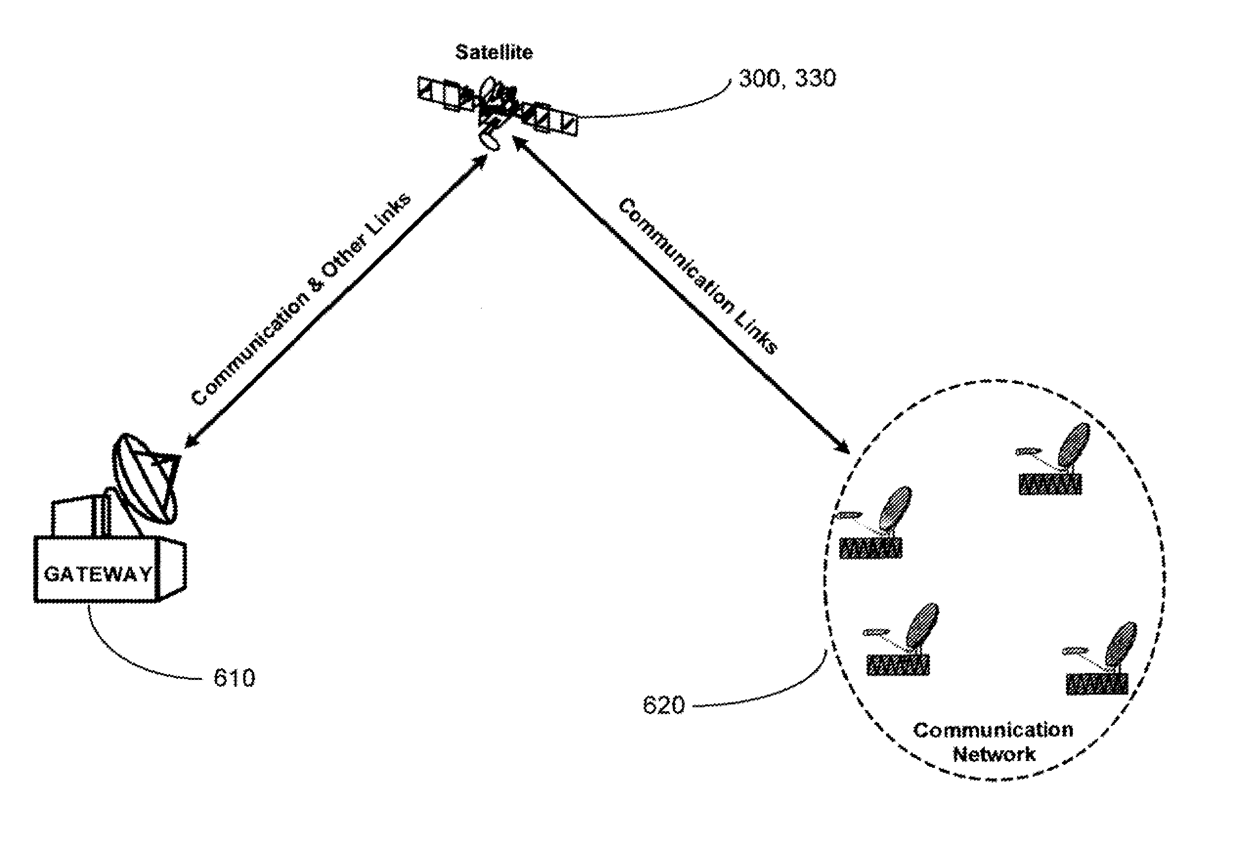
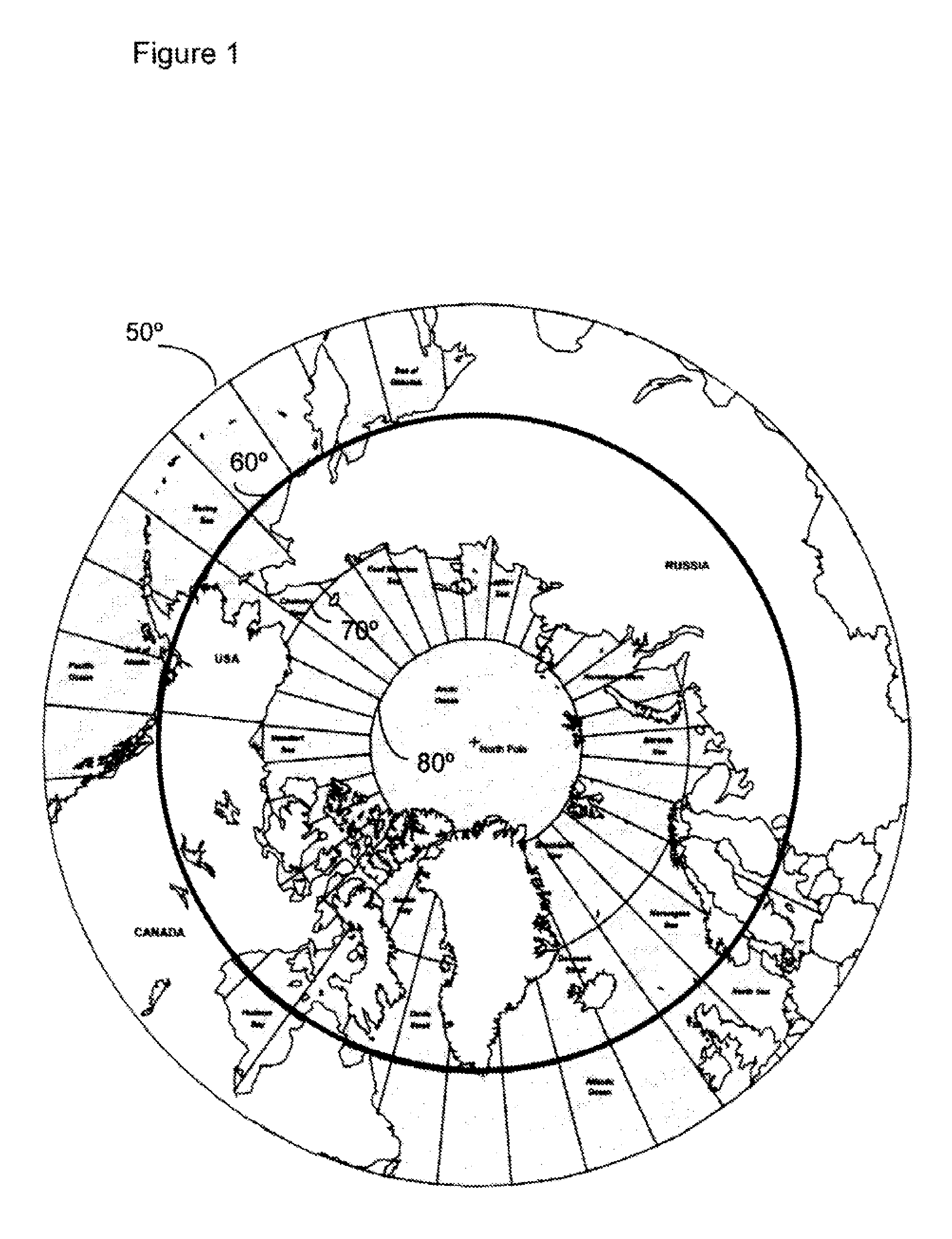
[0035]Contrary to the teachings in the art it has been determined mat a satellite system and method may be provided using satellites in 24 sidereal hour orbits, (geosynchronous) with inclinations, orbital planes, right ascensions and eccentricities chosen to optimize coverage of a particular service area located at high latitudes, A constellation of two satellites can provide continuous coverage of the circumpolar region, which is defined as the area with greater than 60° latitude in either the northern or southern hemispheres (see FIG. 1, which identifies the 60° latitude area of the northern hemisphere). The satellites in this orbit avoid the inner Van Allen belt, of high energy protons.

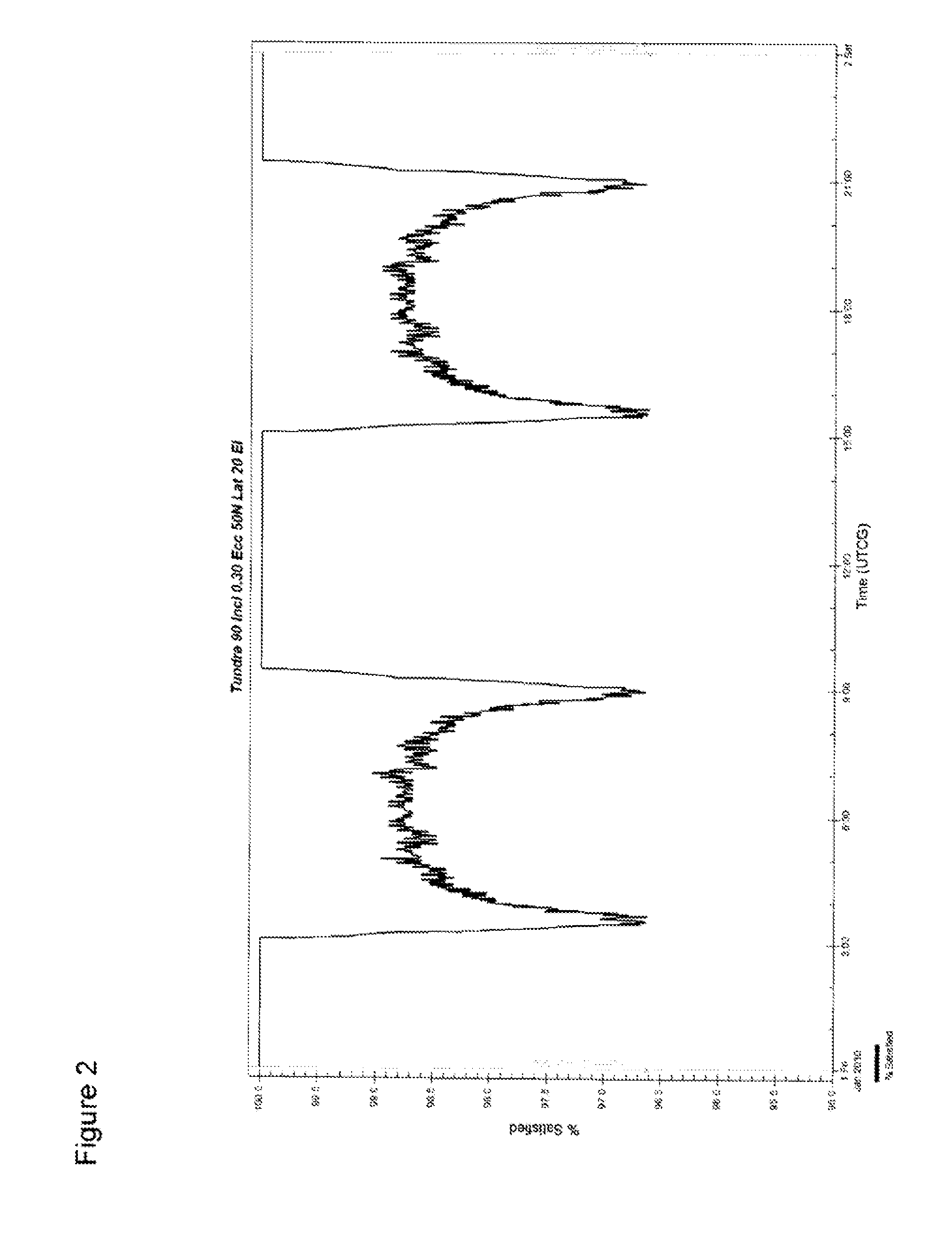
[0036]For example, as shown in FIG. 2, a constellation of two satellites at a 90° inclination and 0.3 eccentricity, will provide a minimum 20° elevation angle for the entire area above 50° North, for much of the time, with the percentage area coverage at a minimum 20° elevation angle never less tha...


PUM


Abstract

The present invention relates to satellite systems and more particularly, to the provision of a satellite system for weather and climate monitoring, communications applications, and scientific research at higher latitudes, referred to as the circumpolar region and defined here as the area with latitudes greater than 60°, in either the northern hemisphere or the southern hemisphere. Contrary to the teachings in the art it has been discovered that a satellite system and method may be provided using satellites in 24 sidereal hour orbits (geosynchronous) with inclinations (70° to 90°), orbital planes, right ascensions and eccentricities (0.275-0.45) chosen to optimize coverage of a particular service area located at high latitudes. A constellation of two satellites can provide continuous coverage of the circumpolar region. The satellites in this orbit avoid most of the Van Allen Belts.

Description

FIELD OF INVENTION[0001]The present invention relates to satellite systems and more particularly, to die provision of a satellite system and method for weather and climate monitoring, communications applications, scientific research and similar tasks at higher latitudes, in either the northern hemisphere or the southern hemisphere.BACKGROUND OF THE INVENTION[0002]Meteorological monitoring satellites and communications satellites are usually located in Geostationary Earth Orbit—(GEO) or Low Earth Orbit (LEO). GEO satellites appear to be motionless in the sky, providing the satellite with a continuous view of a given area on the surface of the Earth. Unfortunately, such an orbit can only be obtained by placing the satellite directly above the Earth's equator (0° latitude), with a period equal to the Earth's rotational period, an orbital eccentricity of approximately zero and at an altitude of 35,789 km. While such orbits are useful in many applications, they are very poor at covering ...

Claims


Application Information

Patent Timeline
Patent Type & Authority Applications(United States)
IPC IPC(8): H04B7/185
CPCH04B7/18519H04B7/195B64G1/002B64G1/1007B64G1/1021B64G1/105B64G1/1085B64G1/242B64G3/00B64G1/1042B64G1/2427B64G1/643
Inventor BIGRAS, ANDRE E.MEGYERI, PETERRIGLEY, JACKSHOAMANESH, ALIREZANG, PAULSINGH, SURINDER PAL
Owner TELESAT CANADA
Why Eureka
Try Eureka