Real-time locating system using GPS time difference of arrival with digital off-air access units and remote units

a real-time locating and digital off-air technology, applied in satellite radio beaconing, measurement devices, instruments, etc., can solve the problems of complex infrastructure, high cost, and inconvenient use of gps for indoor localization, and achieve the effect of minimizing a cost function

Active Publication Date: 2014-11-20
DALI SYST LTD
View PDF0 Cites 35 Cited by
  • Summary
  • Abstract
  • Description
  • Claims
  • Application Information

AI Technical Summary

Benefits of technology

[0012]According to yet another embodiment of the present invention, a mobile station for localization using satellite navigation signals in a DAS is provided. The mobile station includes a receiver operable to receive a wireless signal from an antenna, the signal including a first portion received at the mobile station during a first time period and a second portion received at the mobile station during a second time period, the first portion identifying a first satellite, and the second portion identifying a second satellite. The mobile station also includes a non-transitory computer-readable storage medium comprising a plurality of computer-readable instructions tangibly embodied on the computer-readable storage medium, which, when executed by one or more data processors, cause the one or more data processors to: simultaneously or concurrently analyze the first portion of the signal and the second portion of the signal, and estimate a location of the mobile station based on the simultaneous or concurrent analysis.
[0013]In an embodiment, the mobile station comprises a mobile phone, direction-providing device or portable computer. The estimation of the location can include refining an initial estimate of the location based on the simultaneous or concurrent analysis. The wireless signal can include a GPS, GLONASS, Galileo, QZSS, or BeiDou signal. The instructions, when executed by one or more data processors, further cause the one or more data processors to estimate a location of the antenna in an embodiment. As an example, the location can be estimated based on minimizing a cost function. The instructions, when executed by one or more data processors, further cause the one or more data processors to determine a time difference between a first time when the wireless signal was transmitted from the antenna and a second time when the wireless signal was received at the mobile station in an embodiment. In a particular embodiment, the receiver is further operable to receive a second wireless signal from a second antenna and the simultaneous or concurrent analysis further analyzes the second signal.

Problems solved by technology

Although GPS positioning is prevalent in outdoor applications, indoor localization using GPS is not common, likely due to large signal attenuation caused by the building walls.
Most indoor positioning solutions require unique infrastructure that is complicated and expensive to deploy.

Method used


Image

  • Real-time locating system using GPS time difference of arrival with digital off-air access units and remote units
  • Real-time locating system using GPS time difference of arrival with digital off-air access units and remote units
  • Real-time locating system using GPS time difference of arrival with digital off-air access units and remote units

Examples


Embodiment Construction

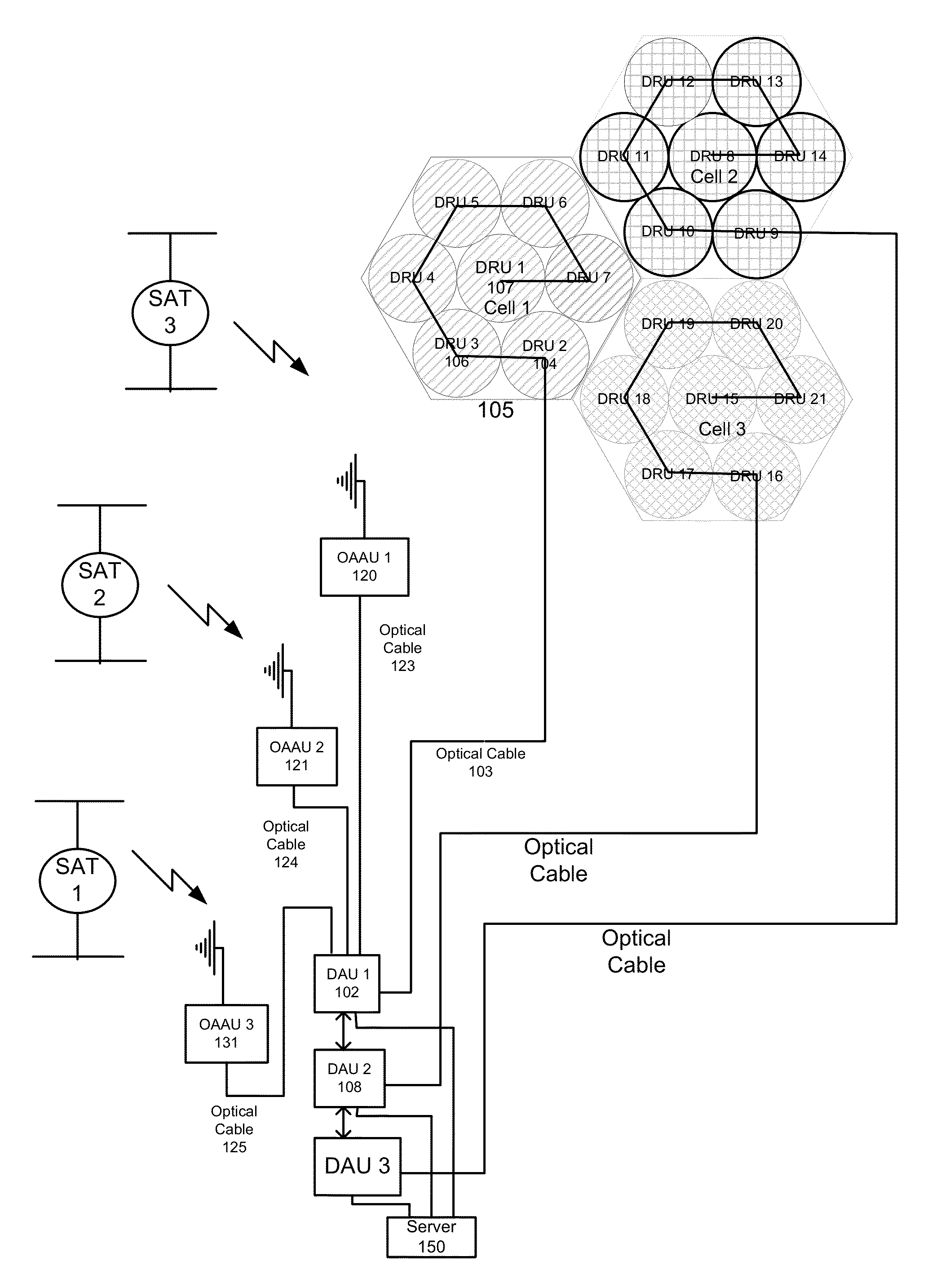
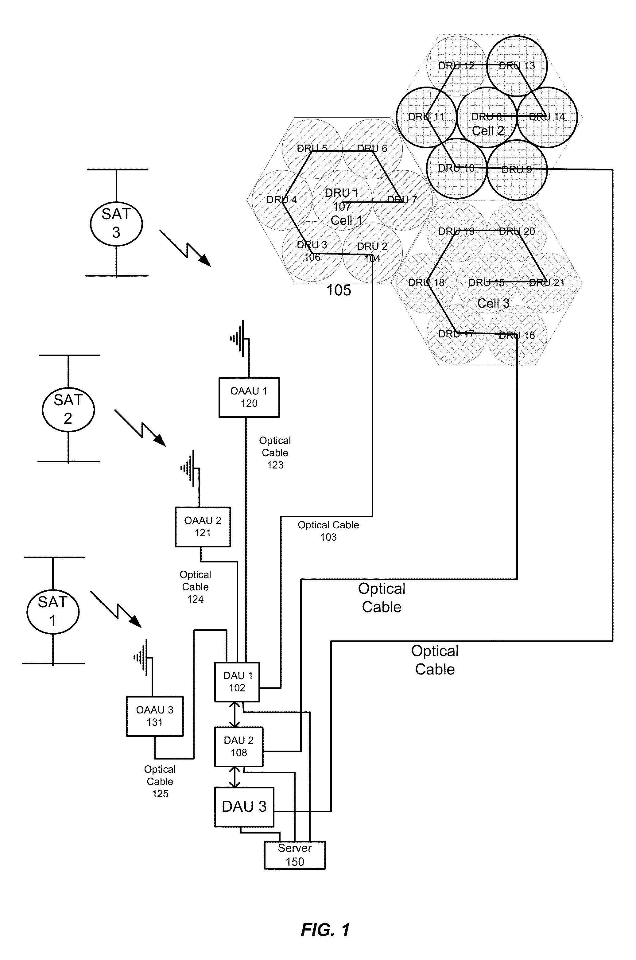
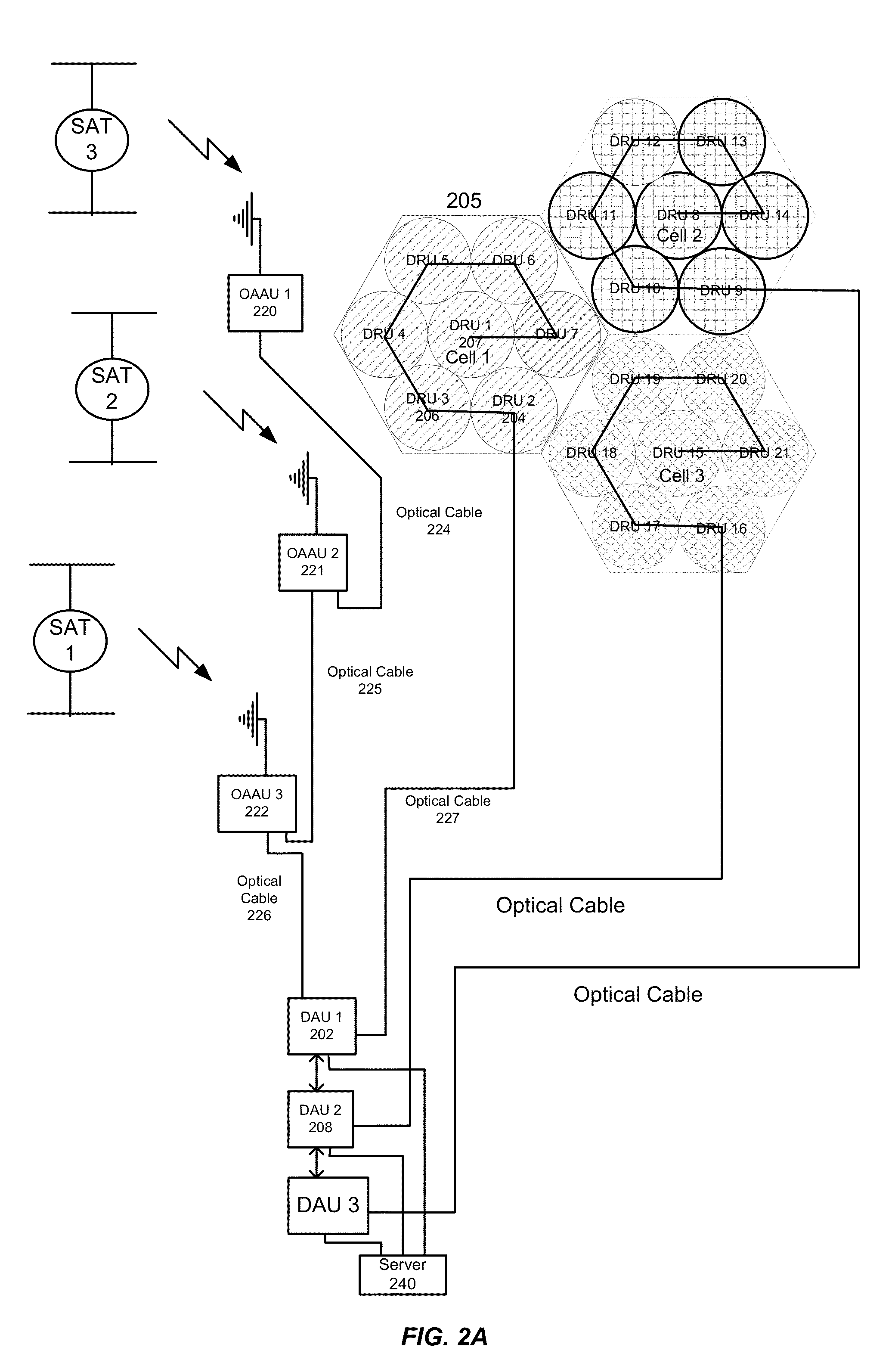
[0044]A distributed antenna system (DAS) provides an efficient means of transporting signals between local units and remote units. The DAS network comprises one or more digital access units (DAUs) that function as the interface between the Off-Air Access Units (OAAU) and the digital remote units (DRUs). The DAUs can be collocated with the OAAUs. The DRUs can be daisy chained together and / or placed in a star configuration and provide coverage for a given geographical area. The DRUs are typically connected with the DAUs by employing a high-speed optical fiber link; however, it will be appreciated that the link between DRUs and DAUs can be made with other types of transport, including but not limited to wireless links, Ethernet cables and other metal connections. This approach facilitates transport of the RF signals from the OAAU to a remote location or area served by the DRUs.

[0045]OAAUs communicate with one of more GPS Satellites over the air. OAAUs are convenient for relaying GPS si...


PUM


Abstract

A real-time locating system (RTLS) for localization using satellite navigation signals in a Distributed Antenna System includes Off-Air Access Units (OAAUs), each being operable to receive an individual satellite navigation signal from a satellite and to route signals optically to a digital access unit (DAU). Remote digital remote units (DRUs) are located at Remote locations and are operable to receive signals the DAUs. Each individual satellite navigation signal can be appropriately delayed (in a manner that accounts for a DRU's location). For each antenna, a separation distance between a mobile station and a DRU can be estimated based on a signal receipt time at the station. In combination, these distances can be used to estimate the mobile station's precise indoor position.

Description

CROSS-REFERENCES TO RELATED APPLICATIONS[0001]This application claims priority to U.S. Provisional Patent Application No. 61 / 815,023, filed on Apr. 23, 2013, entitled “Real-Time Locating System using GPS Time Difference of Arrival with Digital Off-Air Access Units and Remote Units,” the disclosure of which is hereby incorporated by reference in its entirety for all purposes.BACKGROUND OF THE INVENTION[0002]Real-time locating systems (RTLS) are used to automatically identify and track the location of objects or people in real time, usually within a building or other contained area. Currently, no standard for an RTLS has been adopted in a widespread manner, adversely impacting deployment.[0003]ARTLS typically relies on anchors with known positions rather than relying on satellites, since satellite signals are not typically available at indoor positions as a result of signal attenuation resulting from roofs and other building structures.[0004]Despite the progress made in RTLS design an...

Claims


Application Information

Patent Timeline
Patent Type & Authority Applications(United States)
IPC IPC(8): G01S19/01
CPCG01S19/01G01S5/10G01S19/11
Inventor MEERKERK, DARYLSTAPLETON, SHAWN PATRICK
Owner DALI SYST LTD
Why Eureka
Try Eureka