Sensor-aided vehicle positioning system

a technology of vehicle positioning system and sensor, which is applied in the direction of navigation instruments, using reradiation, instruments, etc., can solve the problems of minor inconvenience in navigation, the minimum number of satellites required to accurately determine the position of the satellite receiver may not be available under certain conditions, and the error of gps positional accuracy may be as great as 30 meters

Active Publication Date: 2015-03-19
GM GLOBAL TECH OPERATIONS LLC
View PDF7 Cites 105 Cited by
  • Summary
  • Abstract
  • Description
  • Claims
  • Application Information

AI Technical Summary

Benefits of technology

[0003]An advantage of an embodiment is the detection of objects in a vicinity of a road of travel by vehicle object detection devices for comparison to a digital map to correct any positional errors in the determined GPS position. In addi...

Problems solved by technology

Due to natural and man-made obstructions (e.g., buildings) or natural obstructions (i.e., dense tree cover), the theoretical minimum number of satellites required to accurately determine a position of the satellite receiver may not be available under certain conditions.
It is well known that GPS positional errors may be as great as 30 meters.
While such errors may result in minor inconveniences in navigation as to whether the vehicle is exactly at a location (e.g., ...

Method used


Image

  • Sensor-aided vehicle positioning system
  • Sensor-aided vehicle positioning system
  • Sensor-aided vehicle positioning system

Examples


Embodiment Construction

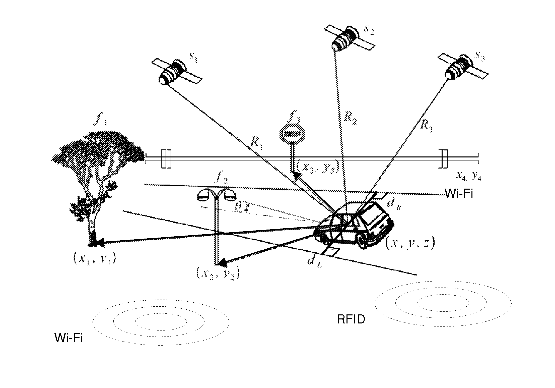
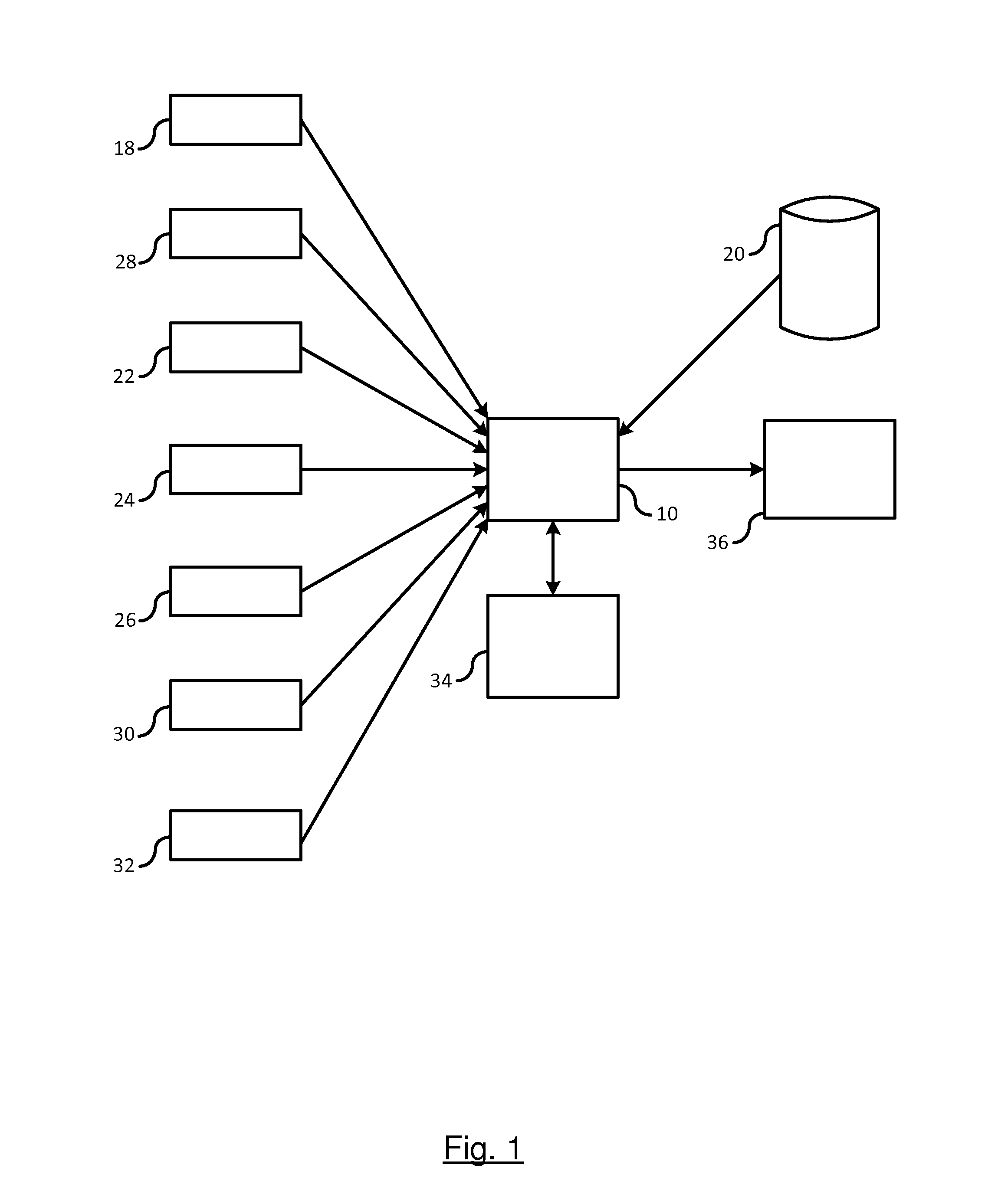
[0015]There is shown in FIG. 1 a sensor-aided vehicle positioning system. The system includes a processing unit 10 for determining a vehicle position on a traveled road. The processing unit 10, may be a standalone processing unit or may be integrated as part of existing system such as a navigation display system. The processing unit 10 obtains input data from various sources for localizing a position of the vehicle on a digital map.

[0016]The vehicle obtains a global position utilizing a vehicle positioning system. The vehicle positioning system includes an onboard Global Navigation Satellite System (GNSS) receiver or other Global Positioning System (GPS) receiver 18. It should be understood that the term GNSS and GPS are used herein are interchangeable. A GNSS system includes a global positioning satellite constellation that includes at least 24 or more satellites orbiting the earth in a predetermined path of travel continuously transmitting time marked data signals. A GNSS receiver...


PUM


Abstract

A method and system for localizing a vehicle in a digital map includes generating GPS coordinates of the vehicle on the traveled road and retrieving from a database a digital map of a region traveled by the vehicle based on the location of the GPS coordinates. The digital map includes a geographic mapping of a traveled road and registered roadside objects. The registered roadside objects are positionally identified in the digital map by longitudinal and lateral coordinates. Roadside objects in the region traveled are sensed by the vehicle. The sensed roadside objects are identified on the digital map. A vehicle position on the traveled road is determined utilizing coordinates of the sensed roadside objects identified in the digital map. The position of the vehicle is localized in the road as a function of the GPS coordinates and the determined vehicle position utilizing the coordinates of the sensed roadside objects.

Description

BACKGROUND OF INVENTION[0001]An embodiment relates generally to vehicle positioning systems.[0002]Global Positioning System (GPS) or other Global Navigation Satellite System (GNSS) receivers operate by tracking line of sight signals. These receivers typically require at least four or more satellites to be continuously available in an unobstructed line of sight of a satellite receiver on a vehicle. Due to natural and man-made obstructions (e.g., buildings) or natural obstructions (i.e., dense tree cover), the theoretical minimum number of satellites required to accurately determine a position of the satellite receiver may not be available under certain conditions. It is well known that GPS positional errors may be as great as 30 meters. While such errors may result in minor inconveniences in navigation as to whether the vehicle is exactly at a location (e.g., intersection), greater issues are present when systems such as lane centering or speed control is used when the vehicle is tra...

Claims


Application Information

Patent Timeline
IPC IPC(8): G01C21/30B60W30/095B60W30/12G05D1/02G01S13/93G01S13/931
CPCG01C21/30G05D1/0212G01S2013/9357B60W30/12B60W30/0956G01S13/931G01S13/06G01C21/3602G01S5/16G01S7/412G01S19/485G01S2013/9322G01S19/42
Inventor ZENG, SHUQINGSALINGER, JEREMY A.LITKOUHI, BAKHTIAR B.PAZHAYAMPALLIL, JOELO'DEA, KEVIN A.NICKOLAOU, JAMES N.SHIELDS, MARK E.
Owner GM GLOBAL TECH OPERATIONS LLC
Why Eureka
Try Eureka