Computer-implemented method for estimating insurance risk of a structure based on tree proximity

Inactive Publication Date: 2015-11-05
BUILDFAX
View PDF1 Cites 21 Cited by
  • Summary
  • Abstract
  • Description
  • Claims
  • Application Information

AI Technical Summary

Benefits of technology

[0006]The present inventor has developed a Tree Proximity Score that correlates highly with the frequency and extent of losses due to wind damage for structures or properties. The Tree Proximity Score may be determined based on a combination of tree characteristic information such as vegetation density values surrounding each of a plurality of structures and insurance loss data such as wind loss data for the structures. The tree characteristic information may be determined based on tree sensor data which may include satellite imagery, aerial imagery, or light detection and ranging (LiDAR). The tree characteristic informati

Problems solved by technology

The cost of replacing a roof due to wind, hail, or other weather damage can be significant and depends on the type of materials being replaced.
The cost to replace more expensive materials such as metal, tile, or slate can reach into the tens of thousands of dollars.
Further, roof damage is present in 85-95% of wind-related insured property losses each year, according to the Insurance Institute for Business & Home Safety (IBHS),

Method used


Image

  • Computer-implemented method for estimating insurance risk of a structure based on tree proximity
  • Computer-implemented method for estimating insurance risk of a structure based on tree proximity
  • Computer-implemented method for estimating insurance risk of a structure based on tree proximity

Examples


example 1

[0082]FIG. 3A is a graph showing the relationship between the Tree Proximity Score of the present disclosure and Wind Loss Frequency as well as Wind Loss Ratio and FIG. 3B is a table showing correlation coefficients between the Tree Proximity Score and Wind Loss Frequency and Tree Proximity Score and Wind Loss Ratio. As shown in the table of FIG. 3B, the correlation coefficient between Tree Proximity Score and Wind Loss Frequency was 0.964 and the correlation coefficient between Tree Proximity Score and Wind Loss Ratio was 0.977. However, other embodiments of the present disclosure may have correlation coefficients representing the relationship between the Tree Proximity Score and Wind Loss Frequency and Tree Proximity Score and Wind Loss Ratio of at least 0.50 up to 1.00, including at least 0.55, 0.60, 0.65, 0.70, 0.75, 0.80, 0.85, 0.90, 0.91, 0.92, 0.93, 0.94, 0.95, 0.96, 0.97, 0.98, and 0.99.

example 2

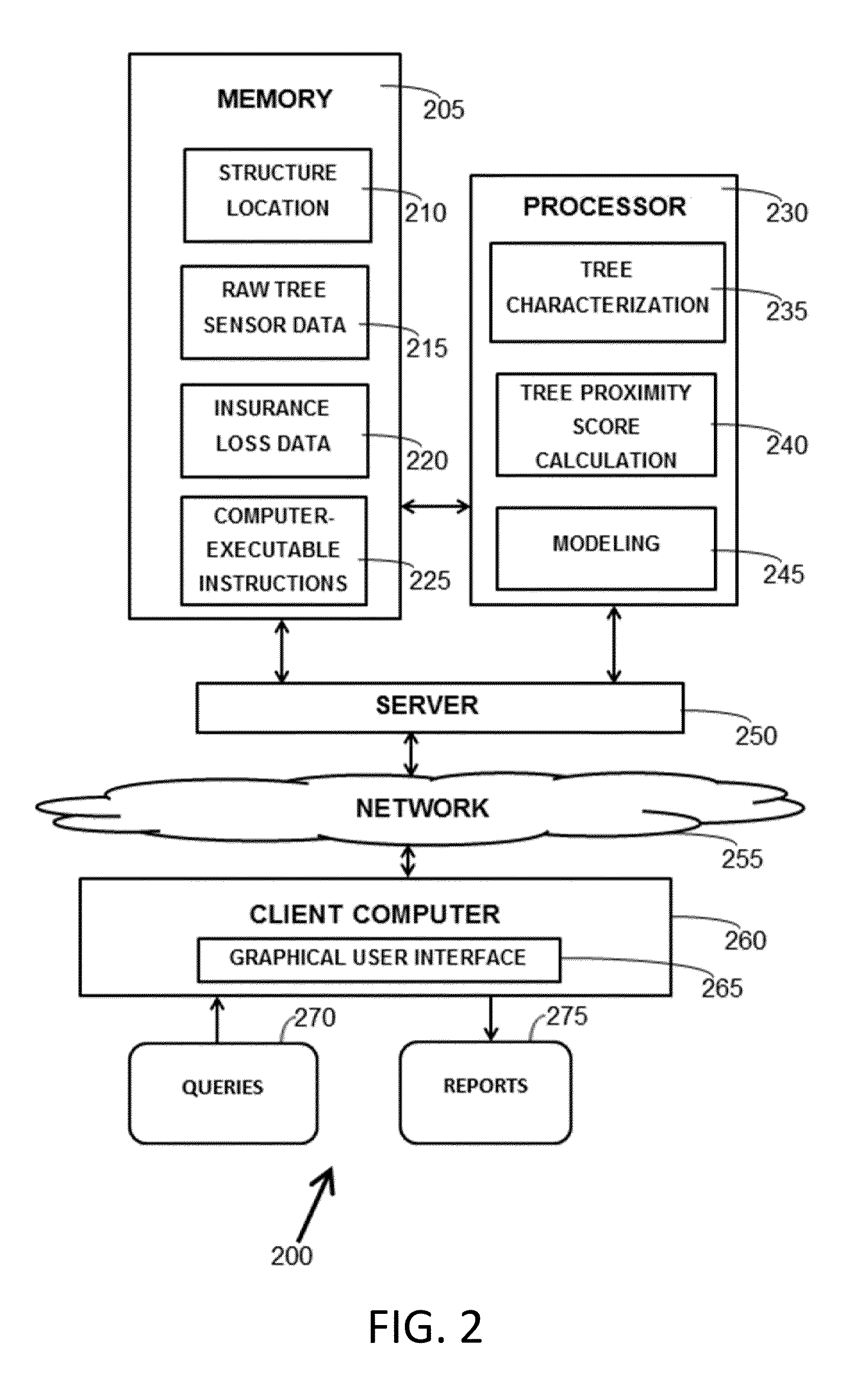
[0083]An end user such as an insurance agent or adjuster uses a client computer to send an address over a network such as the internet to a server connected to or including a processor and memory of this disclosure. The processor then geocodes that address to a latitude and longitude, calculates a Tree Proximity Score for that latitude and longitude according to the computer executable instructions, satellite or aerial imagery for that latitude and longitude, and insurance data stored in the memory, and transmits the Tree Proximity Score through the server over the network to the client computer.

example 3

[0084]An end user such as an insurance agent or adjuster uses a client computer to send geospatial coordinates (a point or a polygon) over a network such as the internet to a server connected to or including a processor and memory of this disclosure. The processor then calculates the Tree Proximity Score for those geospatial coordinates according to the computer executable instructions, satellite or aerial imagery for those geospatial coordinates, and insurance data stored in the memory, and transmits the Tree Proximity Score through the server over the network to the client computer. For polygons, the processor runs the radius from the edges of the polygon.

[0085]The above examples 2 and 3 could be performed on-demand to get a score in less than a second on an individual location, or in batch to get results on millions of properties within a day or two. The score may be calculated in direct response to the query or returned from a memory from a previously calculated value.


PUM


Abstract

Computer-implemented methods of estimating insurance risk of one or more structures are described. The computer-implemented methods may be based on a combination of tree characteristic information and insurance loss data that are used together to calculate a Tree Proximity Score for the one or more structures through a computer processor. The tree characteristic information may include vegetation density data, tree height, tree geometric characteristics, and tree species information, and may be based on tree sensor data which may include satellite imagery, aerial imagery, or LiDAR. The insurance loss data may include wind loss data such as a wind loss frequency, severity, or ratio. The high level of correlation between the Tree Proximity Score and insurance loss data is shown in an example. The Tree Proximity Score may be used in the insurance industry in insurance policy implementation and underwriting.

Description

BACKGROUND OF THE INVENTION[0001]1. Field of the Invention[0002]The present disclosure relates to computer-implemented methods of estimating insurance risk of one or more structures based on a combination of tree characteristic information and insurance loss data that are used together to calculate a Tree Proximity Score for the one or more structures through a computer processor.[0003]2. Description of Related Art[0004]The cost of replacing a roof due to wind, hail, or other weather damage can be significant and depends on the type of materials being replaced. For example, the cost to professionally remove and replace asphalt shingles, the most common type of roofing material, can exceed $8,000 for a typical ranch style home. The cost to replace more expensive materials such as metal, tile, or slate can reach into the tens of thousands of dollars. Further, roof damage is present in 85-95% of wind-related insured property losses each year, according to the Insurance Institute for Bu...

Claims


Application Information

Patent Timeline
IPC IPC(8): G06Q40/08
CPCG06Q40/08
Inventor EMISON, JOSEPH TIERNEY MASTERSWHITE, RICHARD W.
Owner BUILDFAX
Why Eureka
Try Eureka