Check patentability & draft patents in minutes with Patsnap Eureka AI!

Positioning systems

a positioning system and positioning technology, applied in the field of positioning systems, can solve the problems of timing errors in the system and the upper limit of the cluster size, and achieve the effect of increasing accuracy

Active Publication Date: 2018-02-01
U-BLOX
View PDF2 Cites 2 Cited by
  • Summary
  • Abstract
  • Description
  • Claims
  • Application Information

AI Technical Summary

Benefits of technology

This approach allows for accurate position and velocity determination of mobile devices in clusters, even in areas with limited satellite visibility, without the need for a fixed reference receiver or public correction services, enhancing navigation precision and reliability.

Problems solved by technology

Broadly speaking, however, in embodiments the space segment error is a variable for the cluster of devices which is determined at the same time as the position of each device (and device clock offsets) by solving a set of simultaneous equations or minimizing a cost function.
There is an assumption that the space segment error is common to the cluster of mobile devices, which depending upon the tolerable error puts a upper limit on the size of the cluster, albeit this is large, for example 10-100 kilometres.
As described in more detail later, errors result from timing errors in the system, although for processing these are conveniently expressed as distances (by multiplying by the speed of light).

Method used


Image

  • Positioning systems
  • Positioning systems
  • Positioning systems

Examples


second embodiment

ation

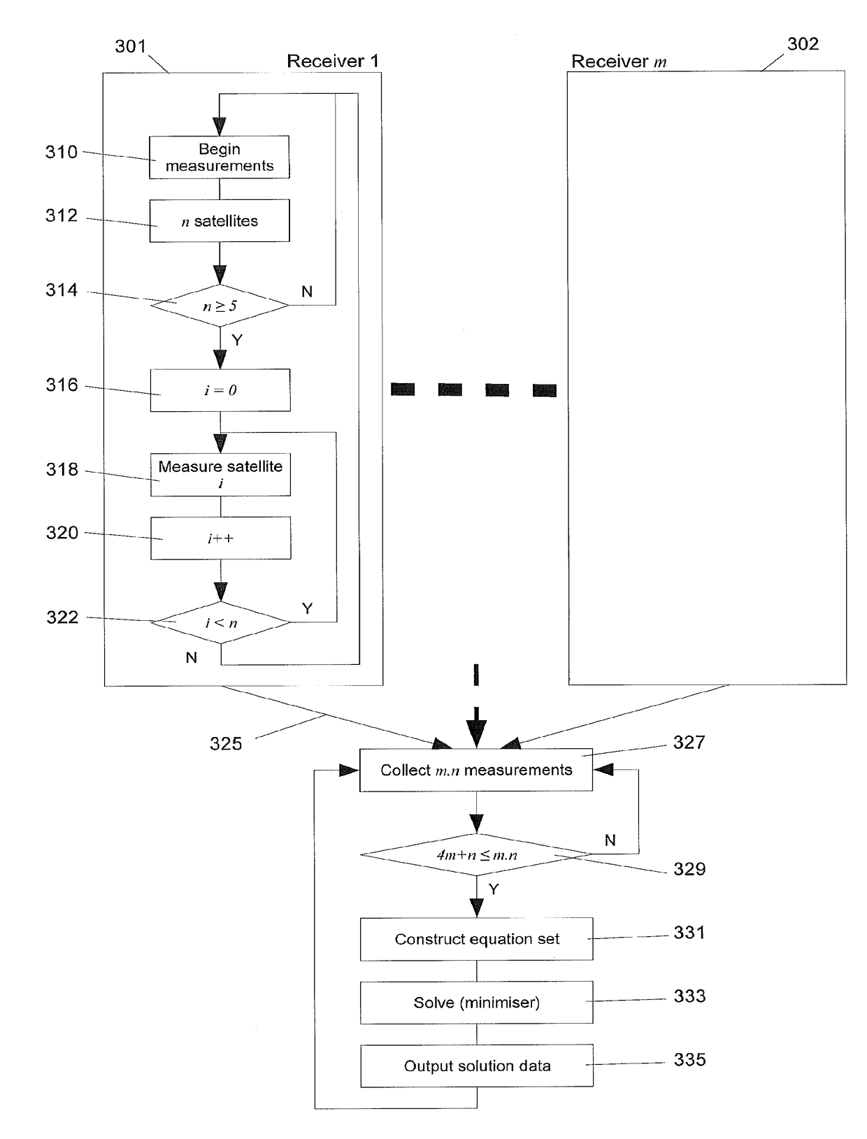
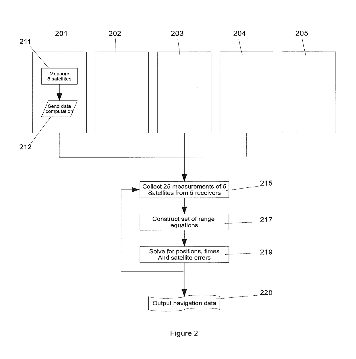
[0126]With reference to the system diagram of FIG. 5, let there be three devices (511) which contain a GNSS receiver and another means to determine their relative positions (515). In this configuration the system is able to accurately determine the positions of all devices based on fewer GNSS (501) measurements (506) than are required in the first embodiment. The following sections describe the different aspects of this system.

[0127]Determining the Relative Positions

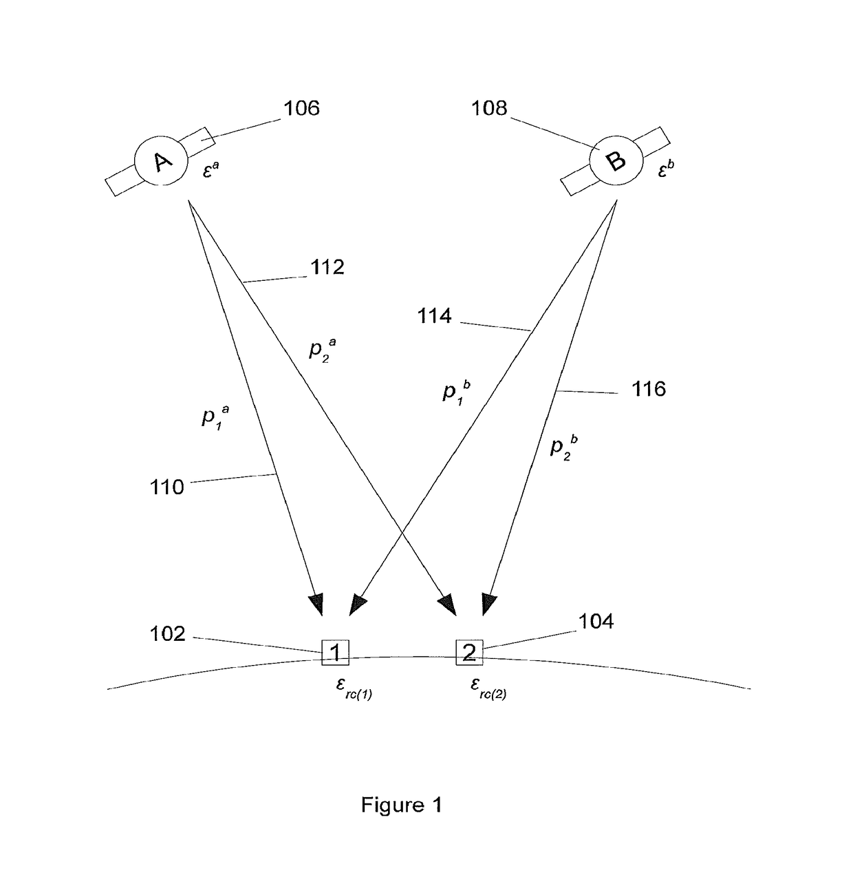
[0128]The means for determining the relative positions could be based on radio signals or other techniques such as acoustic or infrared. There are a number of methods for determining relative positions using radio signals; generally based on a range measurement of some kind. By knowing the three ranges linking the three devices (515) it is possible to determine their relative positions in a conventional Cartesian coordinate frame (608, 610). Usually in the absence of any reference frame the three devices are defined...


PUM


Abstract

A method is provided whereby a group of receivers local to one another make GNSS measurements of a number of satellites, from one or multiple different GNSS's, and by combining the measurements of the same satellites made by the different receivers it is possible given sufficient conditions to determine the positions of the receivers and the satellite errors such that the positions obtained are equivalent to those obtained from a traditional differential GNSS system, without the need for a static reference receiver at a known location.

Description

FIELD OF THE INVENTION[0001]This invention relates to technology and systems for determining the positions and / or velocities of groups of two or more devices which are in communication with one another.BACKGROUND[0002]Navigation systems using radio signals have been around for many years, and today the GPS system (Global Satellite Positioning) is arguably the best known, being the first satellite system to be available and widely used. Such satellite navigation systems are widely referred to within the general class of GNSS's (Global Satellite Navigation Systems) of which Glonass and Galileo are two further examples.[0003]In addition to satellite navigation systems, there are a number of examples of radio location systems based on terrestrial radio signals. These include the E-OTD (Enhanced Observed Time Difference of Arrival) system used on GSM, UWB (Ultrawideband) systems, Wi-fi and ZigBee systems and many others within the general category of RFID (radio frequency identification)...

Claims


Application Information

Patent Timeline
Patent Type & Authority Applications(United States)
IPC IPC(8): G01S19/09G01S19/40G01S19/33G01S19/52
CPCG01S19/52G01S19/09G01S19/33G01S19/40
Inventor BARTLETT, DAVIDTHURMAN, ANDY
Owner U-BLOX
Features
  • R&D
  • Intellectual Property
  • Life Sciences
  • Materials
  • Tech Scout
  • Unparalleled Data Quality
  • Higher Quality Content
  • 60% Fewer Hallucinations
Learn More