Geostationary earth orbit (GEO) earth multispectral mapper (GEMM)

a geostationary earth orbit and multi-spectral mapper technology, applied in the field of multi-spectral mappers, can solve the problems of significant cost overrun, cost and development risk of these systems, and degradation of performance at the edges of the field, so as to minimize the cost of integration and testing, the effect of minimizing the interaction

Active Publication Date: 2018-04-19
CALIFORNIA INST OF TECH
View PDF4 Cites 9 Cited by
  • Summary
  • Abstract
  • Description
  • Claims
  • Application Information

AI Technical Summary

Benefits of technology

[0099]GEMM can be accommodated on commercial communications satellite with minimal impact to the commercial operator's primary goals and that GEMM requirements for pointing, stability, thermal (heat rejection), data, power, mass can be met.
[0100]The sensor interface to the host satellite bus fol

Problems solved by technology

While overlap exists in the fields of view for many of these satellites, degraded performance occurs at the edges of the field.
The challenge for meteorological forecasting agencies is the cost and development risk of these systems, since they require v

Method used


Image

  • Geostationary earth orbit (GEO) earth multispectral mapper (GEMM)
  • Geostationary earth orbit (GEO) earth multispectral mapper (GEMM)
  • Geostationary earth orbit (GEO) earth multispectral mapper (GEMM)

Examples


example electronics

[0049

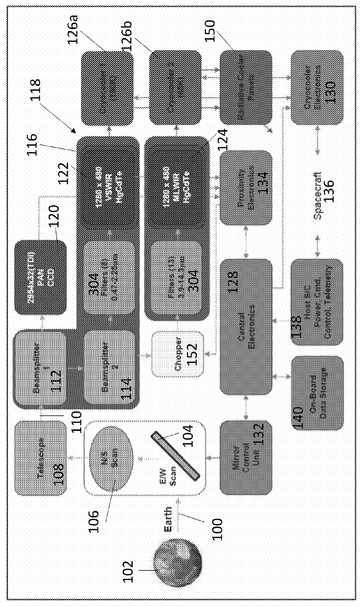
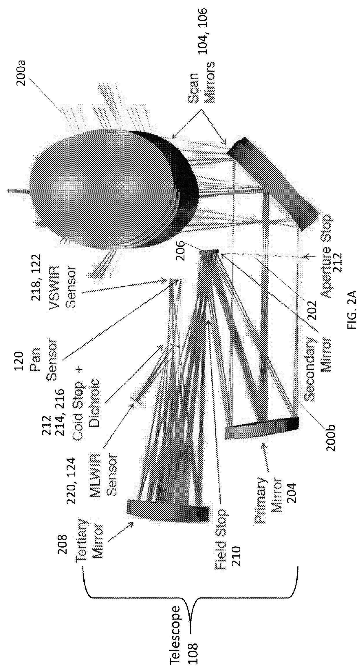
[0050]FIG. 5A illustrates the imager 500 including FPAs, primary M1 (204 in FIG. 2A), secondary M2 (206 in FIG. 2A), tertiary mirror M3 (208 in FIG. 2A), scanning mirrors S1 and S2 (104, 106 respectively in FIG. 2A), and beamsplitters D1, D2 (216 in FIG. 2A). The imager 500 is coupled to electronics comprising the central electronics 128, cryocooler electronics 130, mirror control unit 132, proximity electronics 134, housekeeping unit (HKU) 502, power distribution unit (PDU) 504, power interface board 506, analog to digital converter (ADC) 508, digital processing unit 510, and backplane 512 (for peripheral component interconnect PCI and Command and Data Handling (C&DH).

[0051]Also shown is the electronic circuit 514 for controlling the imager 500 and reading and processing the signals 516 produced by the pixels 302 in response to detecting the electromagnetic radiation 308 (referring also to FIG. 3A-3C). The electronic circuit 514 comprises proximity electronics 134, analog to d...


PUM


Abstract

A multi-spectral imager useful for weather mapping, comprising an array of filters on at least one focal plane array (FPA) including pixels. Each of the filters are associated with a different set of the pixels, and each of the filters transmit a portion of electromagnetic radiation, comprising a different band of wavelengths, to the set of the pixels associated with the filter. A circuit connected to the pixels reads out a signal outputted from each of a plurality of different pixels in the set and outputs the signals to an adder. The adder sums the signals from each of the plurality of different pixels in the set to form a sum used for generating a weather map.

Description

CROSS REFERENCE TO RELATED APPLICATIONS[0001]This application claims the benefit under 35 U.S.C. Section 119(e) of co-pending and commonly-assigned U.S. Provisional Patent Application Ser. No. 62 / 407,706, filed on Oct. 13, 2016, by Kim M. Aaron, Curt A. Henry, James P. McGuire, Dean L. Johnson, Thomas S. Pagano, Suresh Seshadri, Nasrat A. Raouf, Joseph Sauvageau, James K. Wolfenbarger and Fabien Nicaise, entitled “GEOSTATIONARY EARTH ORBIT (GEO) EARTH MULTISPECTRAL MAPPER (GEMM)”, (CIT-7612-P2); which application is incorporated by reference herein.STATEMENT REGARDING FEDERALLY SPONSORED RESEARCH AND DEVELOPMENT[0002]The invention described herein was made in the performance of work under a NASA contract NNN12AA01C, and is subject to the provisions of Public Law 96-517 (35 USC 202) in which the Contractor has elected to retain title.BACKGROUND OF THE INVENTION1. Field of the Invention[0003]The present invention relates to a multispectral mapper and methods of fabricating and using t...

Claims


Application Information

Patent Timeline
IPC IPC(8): G01J3/28
CPCG01J3/2823G01J3/2803G01J2003/2826G01J2003/2806G01J2003/2813G01J3/0264G01J3/36G01J3/0208G01J3/0229G01J3/0286
Inventor PAGANO, THOMAS S.SAUVAGEAU, JOSEPHAARON, KIM A.HENRY, CURT A.JOHNSON, DEAN L.MCGUIRE, JAMES P.NICAISE, FABIENRAOUF, NASRAT A.SESHADRI, SURESHWOLFENBARGER, JAMES K.
Owner CALIFORNIA INST OF TECH
Why Eureka
Try Eureka