V2V Collaborative Relative Positioning System

a technology of relative positioning system and gps data, which is applied in the direction of measurement devices, broadcast service distribution, instruments, etc., can solve the problem of reducing the optimal number of satellites required to accurately determine, and achieve the effect of increasing the confidence level of gps data

Active Publication Date: 2018-07-19
FORD GLOBAL TECH LLC
View PDF49 Cites 17 Cited by
  • Summary
  • Abstract
  • Description
  • Claims
  • Application Information

AI Technical Summary

Benefits of technology

[0008]In one aspect of the invention, a vehicle-to-vehicle collaborative positioning system is provided such that if a host vehicle is receiving less than an optimum number of satellites signals, the host vehicle utilizes GPS data of a neighboring vehicle in a cluster in addition to relative positioning data obtained from on-board sensing devices such as radar, Lidar, or camera systems to adjust and increase the GPS data of the host vehicle from its original state. In addition, if all vehicles within a cluster are receiving less than the optimum number of satellite signals, each vehicle may identify neighboring vehicles having same number of satellite signals as the host vehicle and average the GPS data utilizing the host vehicle GPS data and those identified remote vehicle GPS data. The identified remote vehicles are selected for averaging by the host vehicle if the distance between the host vehicle and the remote vehicle is less than an accuracy radius of the identified neighboring vehicle. The accuracy radius is a function of the degree of closeness that the GPS readings are to the actual position, and determined by the quality of GPS receiver, the characteristics of the surroundings, the number of satellite signals and timing errors of the GPS. The average GPS data will be cooperative used with relative positioning data to increase the confidence level of the host vehicle GPS data. The adjusted GPS data is then broadcast to the cluster. Each vehicle within the cluster will identify itself as a host vehicle and identify neighboring remote vehicles as described herein to increase its GPS data confidence level through averaging. Each vehicle then broadcasts its GPS data and adjusted confidence level to the cluster. Each vehicle within the cluster can then determine which vehicle has the highest GPS data confidence level to rely on.

Problems solved by technology

However, in many instances, natural obstructions (e.g., trees, hills, weather) or man-made obstructions (e.g., buildings) may reduce the optimum number of satellites required to accurately determine a position of the receiving device.
In addition, other factors contributing to the accuracy of the receiver may include, but are not limited to, atmospheric delays, clock errors, orbital errors, and multi-path signals may require more than the optimal number of satellites available to accurately determine the position of the receiver.
However, an issue presents itself when less than an optimal number of satellites signals are obtained and a determination needs to be made as to what other positioning data might be relied on.

Method used


Image

  • V2V Collaborative Relative Positioning System
  • V2V Collaborative Relative Positioning System
  • V2V Collaborative Relative Positioning System

Examples


Embodiment Construction

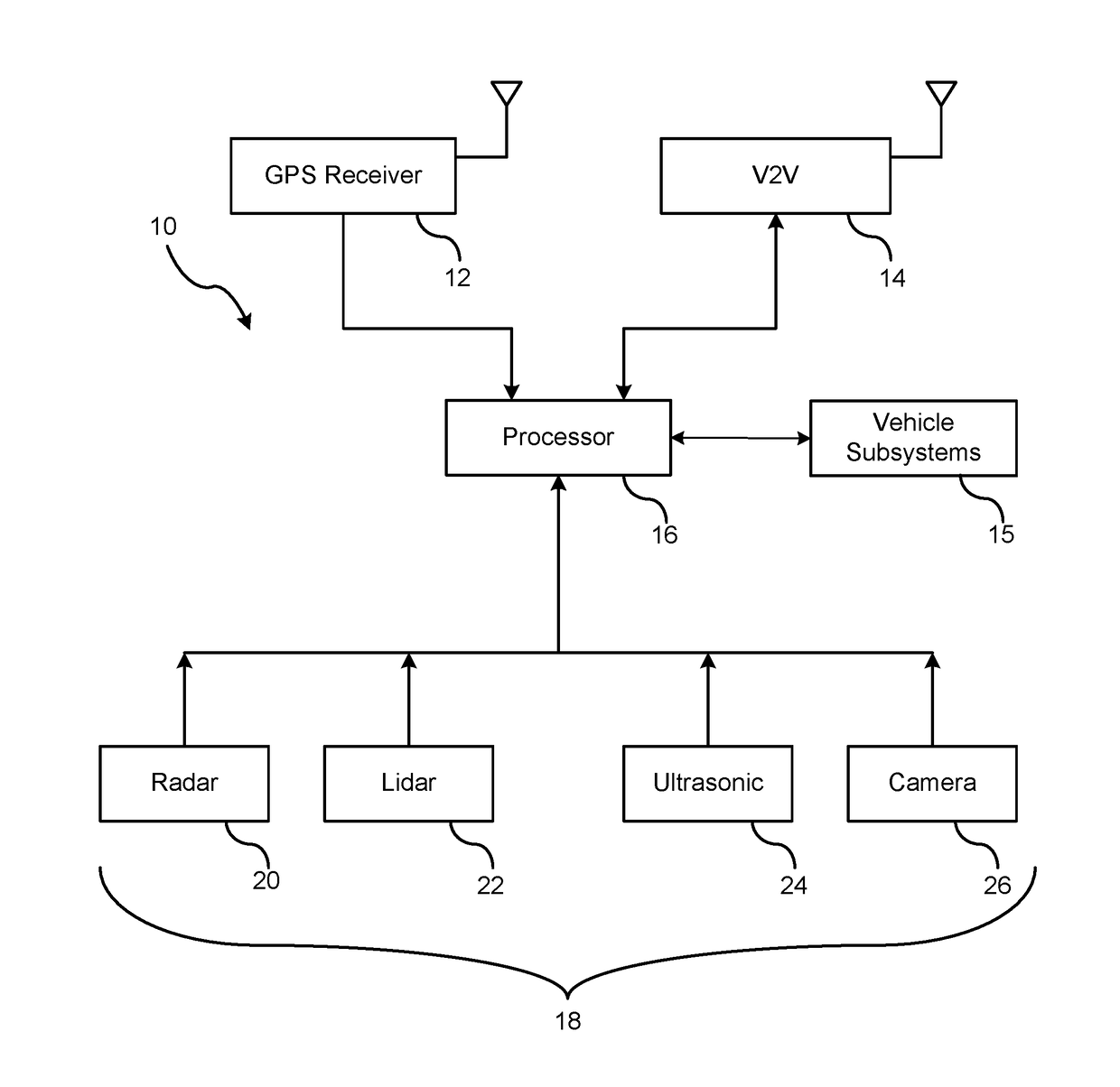
[0015]There is shown in FIG. 1, a block diagram of the vehicle vehicle-to-vehicle (hereinafter used in the detailed description and claims as V2V) collaborative positioning system 10 for a respective vehicle. The collaborative positioning system 10 includes an onboard Global Positioning System (hereinafter used in the detailed description and claims as GPS) receiver 12, a V2V communication device 14, a processor 16, and other on-board sensing devices 18.

[0016]The GPS receiver 12 functions by tracking line of sight signals received by orbiting satellites. The GPS receiver 12 disposed in the vehicle typically requires at least three or more satellites to be continuously available in an unobstructed line of sight. GPS data is received by the GPS receivers 12 for determining its absolute position. In viewing the earth in a two dimensional plane and setting aside altitude, an assumption can be made that the GPS receiver is receiving signals on a two-dimensional plane. Under such conditio...


PUM


Abstract

A method is provided of enhancing GPS data of a host vehicle within a cluster. V2V messages within the cluster are exchanged. A respective vehicle having a highest GPS trust factor is identified utilizing GPS data within the V2V messages. The GPS data of the host vehicle is adjusted as a function of GPS position of the identified vehicle and relative position data between the host vehicle and the identified vehicle.

Description

CROSS REFERENCE TO RELATED APPLICATIONS[0001]Not Applicable.STATEMENT REGARDING FEDERALLY SPONSORED RESEARCH[0002]Not Applicable.BACKGROUND OF INVENTION[0003]The present invention relates generally to GPS-based positioning using V2V collaboration.[0004]A Global Positioning System (GPS) operates by tracking line of sight signals. Line of sight propagation transmits and receives signals only when the receiving devices are in view of each other without any obstacle or obstruction therebetween. An example of a line of sight transmission signal is that used by GPS devices to receive satellite transmission for vehicles.[0005]A GPS receiving device requires a respective minimum number of signals to obtain a high confidence level that the determined position is accurate with minimal errors. A GPS receiver typically must receive unobstructed signals from a minimum of four or more satellites to accurately determine its position. However, in many instances, natural obstructions (e.g., trees, h...

Claims


Application Information

Patent Timeline
Patent Type & Authority Applications(United States)
IPC IPC(8): G01S19/46H04L29/08H04W4/06G01S19/31G01S19/05
CPCG01S19/46H04L67/12G01S19/05G01S19/31H04W4/06G01S19/426G01S19/45G01S5/0072G01S19/396G01S19/421
Inventor NEUBECKER, CYNTHIA M.DATTA GUPTA, SOMAKLEI, OLIVERMURRAY, ALLEN R.
Owner FORD GLOBAL TECH LLC
Why Eureka
Try Eureka