System for building situation awareness

a situation awareness and situation technology, applied in the field of map data building, can solve the problems of affecting the sensor range and accuracy, and impairing the self-navigation of the vessel

Inactive Publication Date: 2018-09-13
ROLLS ROYCE PLC
View PDF0 Cites 5 Cited by
  • Summary
  • Abstract
  • Description
  • Claims
  • Application Information

AI Technical Summary

Benefits of technology

[0016]For example, data may be communicated via an internet cloud-based infrastructure. Alternatively or in addition, low frequency microwave radio

Problems solved by technology

Whilst these can be effective in generating a comprehensive map of the nearby environment, influences within that

Method used


Image

  • System for building situation awareness
  • System for building situation awareness
  • System for building situation awareness

Examples


Embodiment Construction

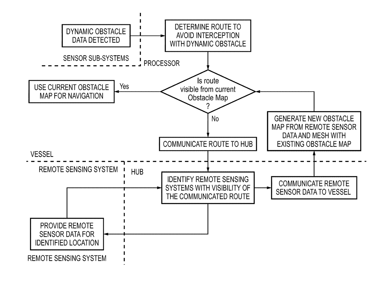
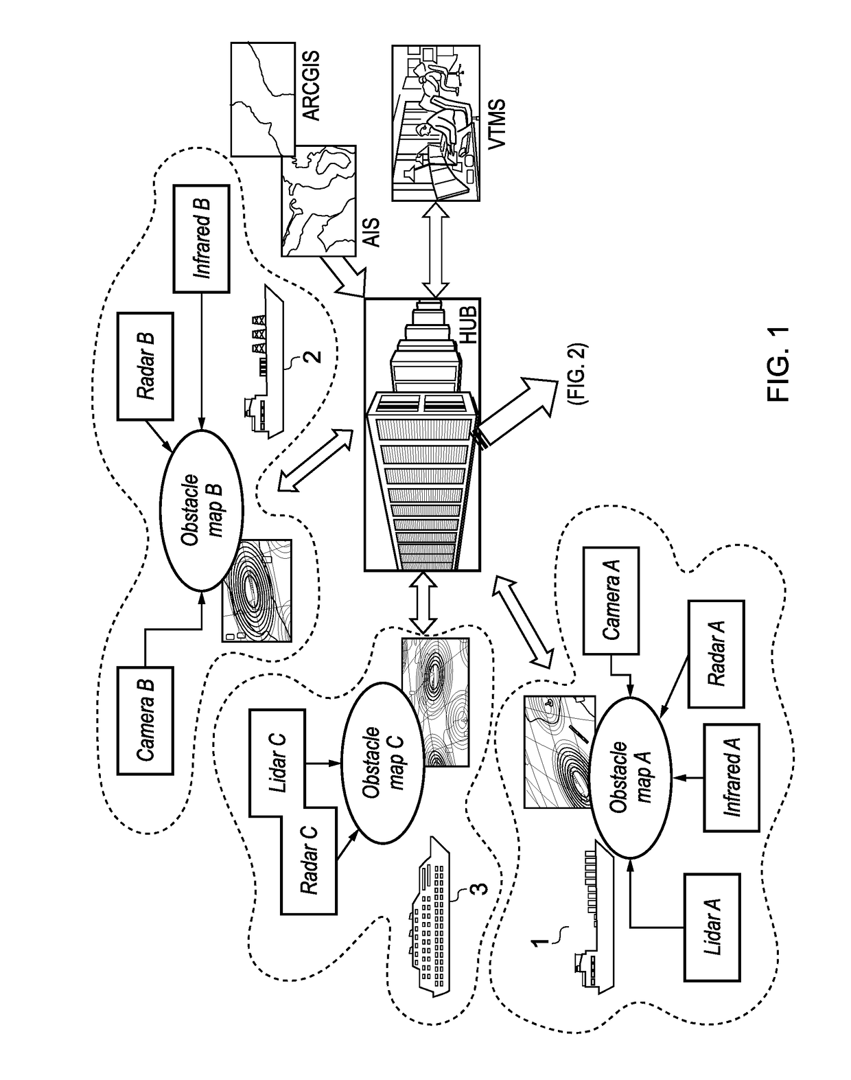
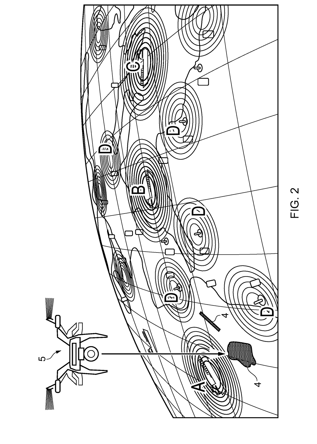
[0025]As can be seen in FIG. 1, a fleet comprises vessels 1, 2 and 3. Each vessel is equipped with sensor sub-systems configured for sensing, in real-time, the presence of obstacles within a local environment of the vessel. Vessel 1 is equipped with sensor sub-systems Lidar A, Infrared A, Radar A and Camera A. A processor on board Vessel 1 collects data from these sub-systems and generates Obstacle Map A which is a real-time map representation of local environment within which Vessel 1 is located. Vessel 2 is equipped with sensor sub-systems Camera B, Radar B and Infrared B. A processor on board Vessel 2 collects data from these sub-systems and generates Obstacle Map B which is a real-time map representation of local environment within which Vessel 2 is located. Vessel 3 is equipped with sensor sub-systems Radar C, Lidar C. A processor on board Vessel 3 collects data from these sub-systems and generates Obstacle Map C which is a real-time map representation of local environment with...


PUM


Abstract

A system for generating a map for use in the navigation of one or more vessels includes: one or more sensor sub-systems provided on a vessel and configured for sensing, in real-time, the presence of obstacles within a local environment of the vessel; a processor associated with the one or more sensor sub-systems for collecting the sensor data and configured for generating therefrom, in a serialised digital format, a real-time map of the local environment surrounding the vessel; data communication means between the processor and a remotely located hub in data communication with remote sensing systems located remotely from the vessel. The hub is configured to collect sensor data from a source remote from the vessel and communicate the sensor data to the processor. The processor is configured on receipt of additional sensor data to generate a real-time map from the sensor data.

Description

CROSS-REFERENCE TO RELATED APPLICATIONS[0001]This application is based upon and claims the benefit of priority from British Patent Application Number 1703968.6 filed Mar. 13, 2017, the entire contents of which are incorporated by reference.BACKGROUNDField[0002]The present invention relates to the building of map data to assist the navigation of a vessel. For example, but without limitation, the vessel may be one of a fleet of unmanned vessels.Description of Related Art[0003]It is known for unmanned vessels to use on board sensing systems to build a local map of their environment in real time and to use this map for self-navigation. Map data collected may identify static obstacles such as land masses as well as dynamic obstacles such as other vessels moving within the mapped environment.[0004]Current concepts and technologies combine multiple sensors of various types to compensate for limited range / accuracy of individual sensors in various settings. Whilst these can be effective in g...

Claims


Application Information

Patent Timeline
IPC IPC(8): G01C21/20G05D1/02G01S13/86G08G3/00
CPCG01C21/203G05D1/0206G01S13/865G08G3/00G01C21/005G08G3/02G01S7/003G01S13/937
Inventor RACHMAWATI, LILY
Owner ROLLS ROYCE PLC
Why Eureka
Try Eureka