Dual leo satellite system and method for global coverage

a satellite system and satellite technology, applied in the field of satellite systems, can solve the problems of only getting orbit, poor coverage at higher latitudes, and high cos

Active Publication Date: 2019-06-13
TELESAT TECHNOLOGY CORPORATION
View PDF0 Cites 24 Cited by
  • Summary
  • Abstract
  • Description
  • Claims
  • Application Information

AI Technical Summary

Benefits of technology

[0013]The polar LEO constellation and inclined LEO constellation work together as a hybrid constellation to achieve true global coverage, with a minimum elevation angle of approximately 20 degrees, requiring fewer satellites than that required by a single LEO constellation at a similar altitude. For example, using only a polar LEO constellation as described above, one would need 168 satellites to provide global coverage at minimum 20 degrees elevation angle. In comparison, the hybrid constellation of the invention only requires 117 satellites. A minimum elevation angle of approximately 20 degrees is preferred as this allows the use of electronically scanned array antennas at the user terminal. It improves the quality and efficiency of the link as the distance between the user and the satellite is less with higher elevation angles and the signal incurs less atmospheric attenuation, an important factor at higher frequencies such as Ka-band. Additional satellites can be added gradually, possibly as the demand increases, resulting in better look angles corresponding to an increase in robustness of the link.
[0016]Users normally connect to the satellite systems through one of the high capacity narrow steerable beams on the satellite. By using narrow steerable beams, the satellite's resources, in terms of power and bandwidth, can be concentrated where the markets are located. It has been observed that land mass only accounts for about 30% of the Earth's surface, and further, that most of the human population resides in 6% of the surface area. Thus, it is not an efficient use of resources to provide broadband coverage over 100% of the Earth's surface, all of the time, as many prior art systems try to achieve. To ensure all users can monitor and gain access to the satellite network anywhere on the Earth when located in areas not served by narrower, high capacity steerable beams, each satellite will have a Wide Area Coverage beam serve the satellite's entire field of view. The Wide Area Coverage beam, with lower capacity than a narrow steerable beam, allows for more robust network management and user on-demand requests for a high capacity beam coverage. That is, a user terminal in an area currently not served by a narrow high capacity beam is able to contact a satellite via the Wide Area Coverage beam and request access to the satellite via a higher bandwidth, narrow steerable beam. The Wide Area Coverage beams, which cover the entire globe continuously, also allow broadcast type services, such as pushing IP content to the user terminal and software distribution.

Problems solved by technology

Satellite communications systems can provide broadband services to remote areas, but they have a very substantial cost.
Unfortunately, such an orbit can only be obtained by placing the satellite directly above the Earth's equator (0° latitude), with a period equal to the Earth's rotational period, and which requires an altitude of 35,789 km.
While such orbits are useful in many applications, they are very poor at covering higher latitudes, not being very useful above 70° latitude for reliable mobile communications.
GEO communications satellite links become unreliable or fail as the elevation angle to the satellite decreases with increasing latitude (elevation angle refers to the line-of-sight angle between the user on the ground and the satellite as measured from the horizon).
As well, GEO satellites have latency issues, i.e. they introduce a considerable time delay in the transmission of data as signals travel back and forth between the ground-based devices and the satellite in orbit.
The higher power requirements and larger antennas result in increased cost of the satellites, and the increased satellite mass and higher orbit altitude increase the cost of launching into this orbit.
However, some HEO orbits pass through the Van Allen belts, which expose them to high levels of radiation, reducing the life of the satellite.
Also, HEO satellites have an apogee approximately the same distance from the Earth as GEO satellites, thus incurring similar latency issues.
But because these satellites are deployed in an equatorial orbit, they are not effective for communications above a latitude of about 45 degrees north or south.
Because of the way these systems are designed, they are both quite expensive.
And if one wished to increase the number of communication channels available on the Krebs and Wyler systems, one would have to do so in very large and expensive increments, adding hundreds of new satellites at a time (i.e. one basically needs to double the number of planes, or add a new set of satellites equal to the number in the initial constellation).

Method used


Image

  • Dual leo satellite system and method for global coverage
  • Dual leo satellite system and method for global coverage
  • Dual leo satellite system and method for global coverage

Examples


Embodiment Construction

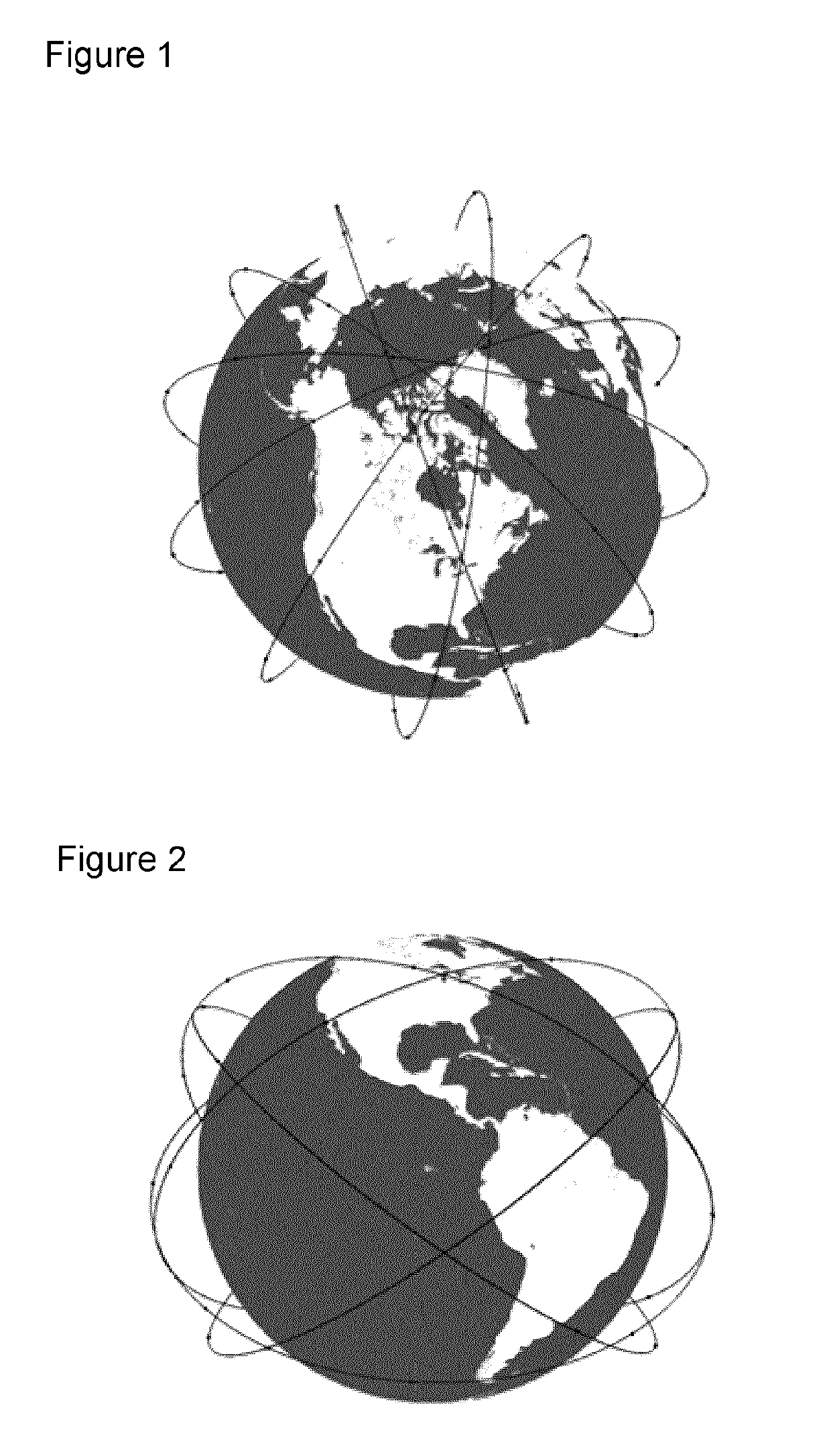
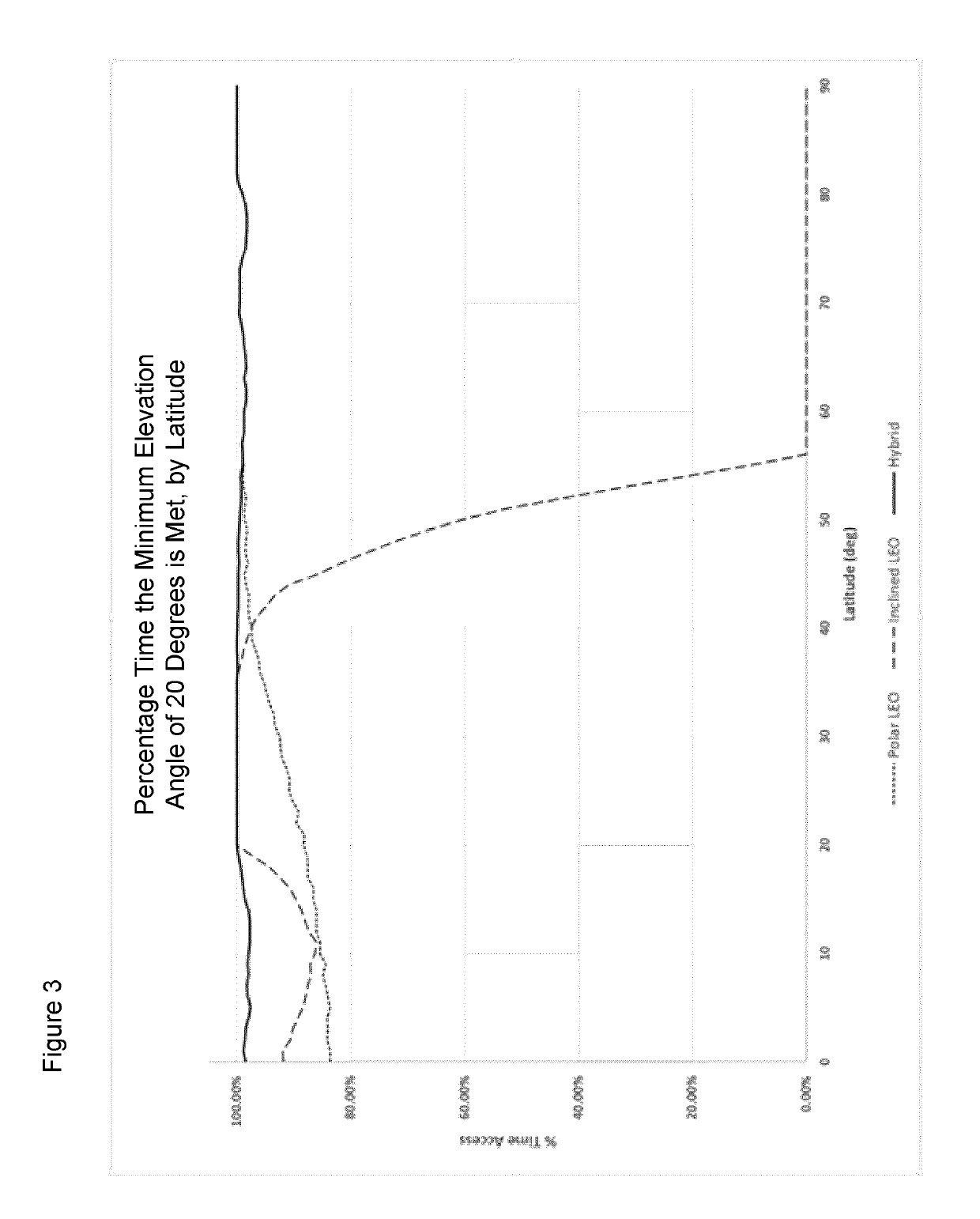
[0034]The LEO hybrid constellation of the invention consists of two mutually-supporting constellations: a polar LEO constellation and an inclined LEO constellation. Complete global, broadband communication coverage with a minimum elevation angle of approximately 20 degrees can be provided with a total of 117 satellites, 72 in the polar LEO constellation and 45 in the inclined LEO constellation. Unlike other proposed LEO systems, initial service to any point on the globe can begin with a much smaller number of satellites; the completion of the polar constellation of 72 satellites, which provides global coverage with a minimum elevation angle of approximately 12 degrees. The subsequent launch of the inclined constellation of 45 satellites will increase the minimum elevation angle to approximately 20 degrees.

[0035]In the preferred embodiment the polar LEO constellation (see FIG. 1) is deployed to the following parameters:[0036]Constellation of 72 satellites, plus spares[0037]12 satelli...


PUM


Abstract

The present invention relates to satellite systems and more particularly, to the provision of a satellite system and method for communications applications, with global coverage. An optimal method of providing global broadband connectivity has been discovered which uses two different LEO constellations with inter-satellite links among the satellites in each constellation, and inter-satellite links between the constellations. The first constellation is deployed in a polar LEO orbit with a preferred inclination of 99.5 degrees and a preferred altitude of 1000 km. The second constellation is deployed in an inclined LEO orbit with a preferred inclination of 37.4 degrees and a preferred altitude of 1250 km.

Description

FIELD OF INVENTION[0001]The present invention relates to satellite systems and more particularly, to the provision of a satellite system and method for communications applications, with global coverage.BACKGROUND OF THE INVENTION[0002]There is a huge demand for wireless communications world-wide, at every level. Commercial and personal demand for Smartphones, tablets, and the like, continue to grow, as do the number and variety of military and aeronautical applications. As well, the demand for ever increasing bandwidth is also growing as customers expect to have access to high-bandwidth services such as video-conferencing, video on demand, broadcast and multimedia Internet services no matter where they are, and whether or not they are mobile.[0003]The need for access and bandwidth is not limited to highly populated areas. Many governments and communications authorities have expressed an interest in providing the same access to communications services in rural and sparsely populated ...

Claims


Application Information

Patent Timeline
Patent Type & Authority Applications(United States)
IPC IPC(8): H04B7/185H04B7/195
CPCH04B7/18521H04B7/195H04B7/18578H04B7/18534H04B7/18513H04B7/185H04H20/74H04H20/91H04W84/06
Inventor WENDLING, DAVID
Owner TELESAT TECHNOLOGY CORPORATION
Why Eureka
Try Eureka