
EXTRINSIC CALIBRATION METHOD OF MULTIPLE 3D LiDAR SENSORS FOR AUTONOMOUS NAVIGATION SYSTEM

a technology of autonomous navigation and calibration method, which is applied in the direction of reradiation, measurement devices, instruments, etc., can solve the problems of not considering the calibration of multiple lidar sensors, the difficulty of practicizing the application of sensors to an actual commercial system, and the considerable modification of techniques. achieve the effect of robust performan

Pending Publication Date: 2021-04-08
KOREA UNIV RES & BUSINESS FOUND
View PDF0 Cites 11 Cited by
  • Summary
  • Abstract
  • Description
  • Claims
  • Application Information

AI Technical Summary

Benefits of technology

The present disclosure describes an extrinsic calibration method for multiple 3D LiDAR sensors used in an autonomous navigation system. This method can easily calibrate the sensors without needing to reorganize the environment or add separate artificial marks. The method takes into account the uncertainty of the environment and can calibrate the sensors with different points of view. The technical effect of this method is that it allows for accurate and robust performance of the autonomous navigation system.

Problems solved by technology

However, it is difficult to practically apply the sensor to an actual commercial system due to its high price.
Although plane information detected by a 3D sensor may be used, it requires considerable modification of the technique.
According to the method, although it is possible to calibrate the coordinate system between the vehicle and the LiDAR sensor without additional environmental reorganization, the calibration between multiple LiDAR sensors has not been considered.
First, when an autonomous navigation system equipped with multiple sensors is commercialized, a large number of systems must be collectively calibrated.
Moreover, the sensors are often attached and detached when inspecting the platforms or reconfiguring the sensor systems.
However, in view of extrinsic parameter calibration, the reduction of the overlapping area makes it difficult to determine the extrinsic parameters between the sensors.
However, the registration may fail when the environment is severely changed or the viewpoints of the two point clouds are significantly different.
In the case of extrinsic parameter calibration, it is difficult to use the registration algorithm in a sensor configuration having different points of view.
However, since artificial calibration objects are usually small, the measuring points of an object are only a small part of the point clouds provided by the LiDAR sensor.
As a result, the calibration result becomes sensitive to sensor uncertainty, and the user sometimes needs to set the area of the object without automatically detecting the object.
The trajectory can be obtained using Inertial Navigation System (INS) or visual odometry, but it is not an easy task to estimate the exact trajectory of the system.
Therefore, a trajectory estimation error may undesirably lead to an estimation error for extrinsic parameters.

Method used


Image

  • EXTRINSIC CALIBRATION METHOD OF MULTIPLE 3D LiDAR SENSORS FOR AUTONOMOUS NAVIGATION SYSTEM
  • EXTRINSIC CALIBRATION METHOD OF MULTIPLE 3D LiDAR SENSORS FOR AUTONOMOUS NAVIGATION SYSTEM
  • EXTRINSIC CALIBRATION METHOD OF MULTIPLE 3D LiDAR SENSORS FOR AUTONOMOUS NAVIGATION SYSTEM

Examples


Embodiment Construction

[0051]Hereinafter, embodiments of the present disclosure will be described in detail with reference to the accompanying drawings.

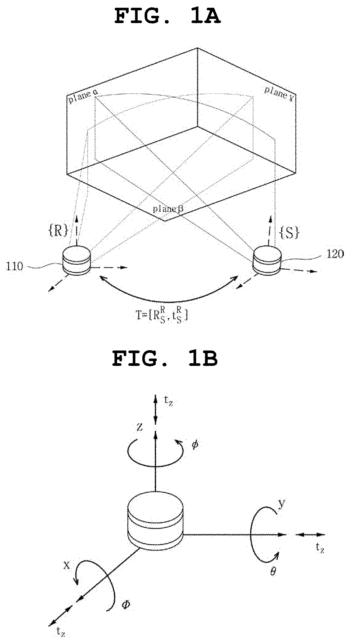
[0052]FIGS. 1A and 1B are views showing the concept of extrinsic parameter calibration of multiple 3D LiDAR sensors 110 and 120 for an autonomous navigation system according to the present disclosure. As shown in FIG. 1A, each of the 3D LiDAR sensors 110 and 120 is installed in an autonomous navigation system, such as a vehicle, at different locations to perform sensing in different views and to collect point clouds.

[0053]Herein, the coordinate system of any one (hereinafter, referred to as a “reference LiDAR sensor 110”) of the multiple 3D LiDAR sensors 110 and 120 may be set to {R}, and the relative coordinate of the remaining one (hereinafter, referred to as a “calibration LiDAR sensor 120”) of the 3D LiDAR sensors 110 and 120 is calculated on the basis of the reference LiDAR sensor 110 so that the coordinate system of the calibration LiDAR sensor 120 m...


PUM


Abstract

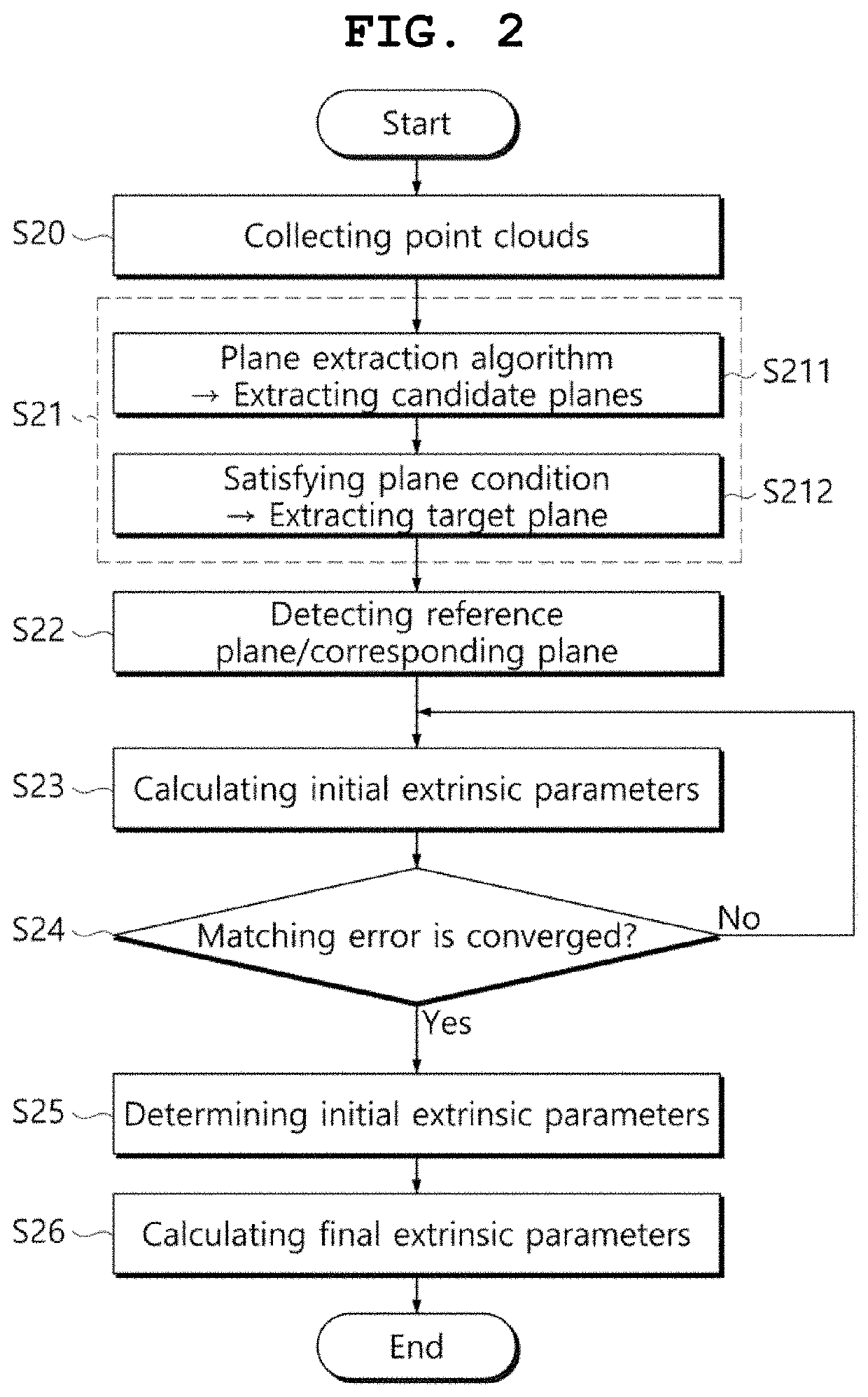
An extrinsic calibration method of multiple 3D LiDAR sensors for an autonomous navigation system is proposed, the method including collecting point clouds by each of the multiple 3D LiDAR sensors; extracting multiple target planes corresponding to a plane from the point clouds of each of the 3D LiDAR sensors; by using the target plane of any one of the multiple 3D LiDAR sensors as a reference plane, detecting a corresponding plane from the target planes of each of the remaining of the 3D LiDAR sensors on the basis of a similarity with the reference plane; calculating initial extrinsic parameters for matching between the reference plane and the corresponding plane based on plane parameters of the reference plane and corresponding plane corresponding to each other; and calculating final extrinsic parameters that minimize variance of measurement points for the reference plane and corresponding plane, on the basis of the initial extrinsic parameters.

Description

CROSS REFERENCE TO RELATED APPLICATION[0001]The present application claims priority to Korean Patent Application No. 10-2019-0122310, filed Oct. 2, 2019, the entire contents of which is incorporated herein for all purposes by this reference.BACKGROUND OF THE INVENTIONField of the Invention[0002]The present disclosure relates to a point cloud correction method of an autonomous navigation system using multiple 3D LiDAR sensors and, more particularly, to an extrinsic calibration method of multiple 3D LiDAR sensors for an autonomous navigation system, the method calibrating the relative position, that is, extrinsic parameters, between point clouds collected from the multiple 3D LiDAR sensors.Description of the Related Art[0003]Unmanned driving technology is being applied to robots and automobiles, and thus is accelerating the commercialization of autonomous navigation systems driving in urban environments in recent years. For this reason, for the safety of systems and users, and the acc...

Claims


Application Information

Patent Timeline
IPC IPC(8): G01S7/497G01S17/931G01S17/894
CPCG01S7/497G01S17/894G01S17/931G01S17/87G01S17/89G01S7/4972
Inventor CHUNG, WOOJINLEE, HYUNSUK
Owner KOREA UNIV RES & BUSINESS FOUND
Learn More