Subterranean target steering strategy

a steering strategy and subterranean technology, applied in the direction of cosmonautic vehicles, transportation and packaging, aircraft, etc., can solve the problems of cost, payload performance consequences, and no longer obtain the benefits of geostationary orbi

Inactive Publication Date: 2000-10-24
HUGHES ELECTRONICS
View PDF7 Cites 17 Cited by
  • Summary
  • Abstract
  • Description
  • Claims
  • Application Information

AI Technical Summary

Problems solved by technology

The price of staying in geostationary orbit is that a satellite in geostationary orbit is constantly being pulled away from that orbit by environmental forces that must be countered if the satellite is to remain in geostationary orbit.
Geostationary satellites must therefore allocate much of their launch weight to propellant rather than payload, and when that propellant is exhausted, the benefits of geostationary orbit no longer obtain.
These costs are well known, and so many satellites are operated in geosynchronous orbits rather than geostationary orbits.
These have consequences on payload performance.
For example, for communications satellites, these effects cause ground antenna gain losses due to azimuth and elevation variation, variations in equivalent isotropic received power (EIRP) due to range variation, frequency variations due to Doppler effects of range rate, and variations in EIRP due to atmospheric attenuation variations with horizon angle.
Typically, the orbit period, eccentricity and true anomaly are controlled to some degree by "east-west station keeping" or "drift and eccentricity" maneuvers, but the orbit inclination control is limited or non-existent.
Such pointing variations can cause the payload beam to deviate sufficiently from the intended service region that coverage of the intended service region is insufficient, or unacceptable intrusion and interference in other regions occurs.
Note that, since the effects of parallax will be different for different ...

Method used


Image

  • Subterranean target steering strategy
  • Subterranean target steering strategy
  • Subterranean target steering strategy

Examples


Embodiment Construction

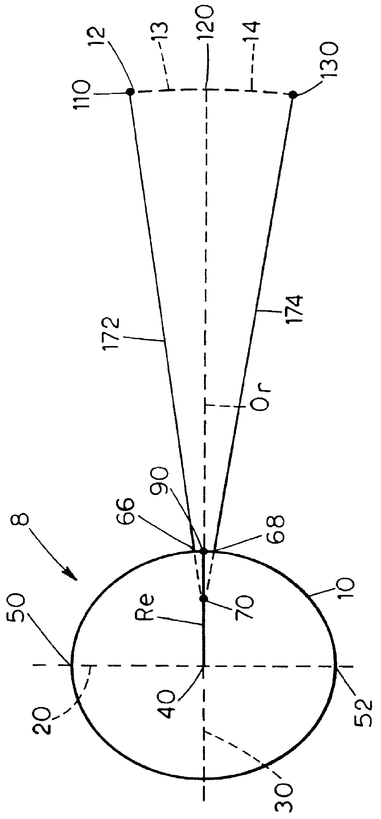
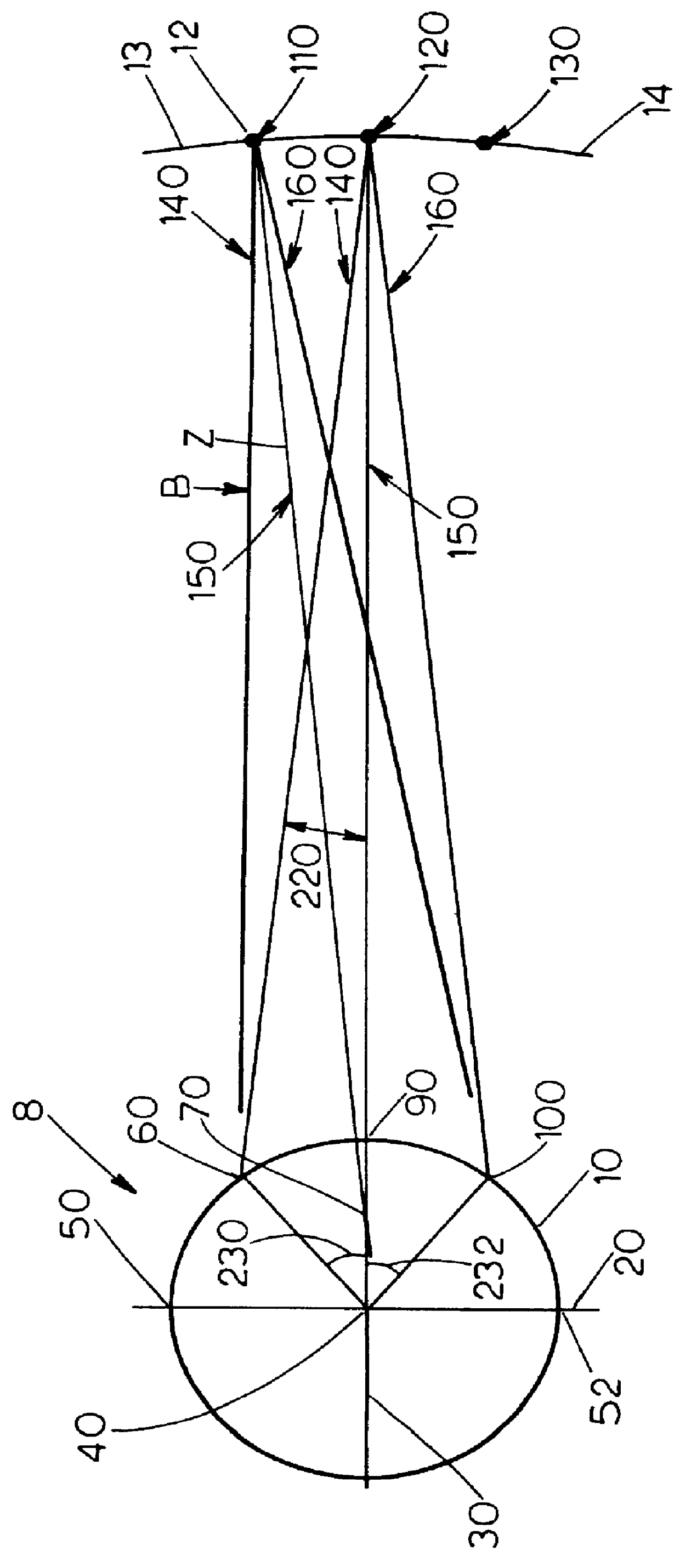
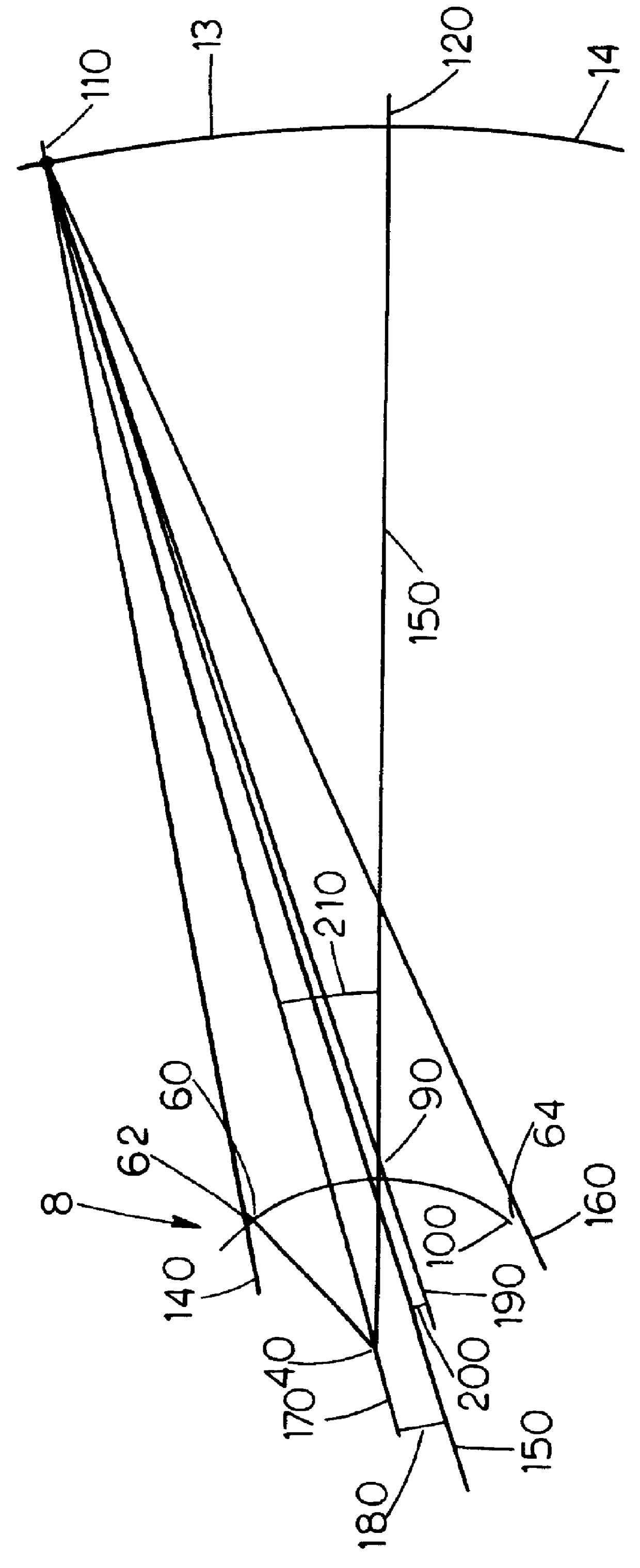
For purposes of comparison, it is helpful to compare the performance of the subterranean target point methodology. FIG. 3 is a graphical comparison of the present invention to the methodology and results of the Westerlund '540 patent. A line between the satellite 12 at its northern orbit extreme 110 and the earth center 40 is represented by the reference line 170. Line 190 represents a line from the satellite 12 to the center 90 of the ISA. The angle 200 is subtended between lines 150 and 190. The Westerlund '540 patent gives formulas for the appropriate offset pointing angle 180 (represented below by Beta), which is the angle between line 170 and the boresight 150 (which intersects the subterranean target point 70 chosen using the methodology described above and thus is at a known location). The Westerlund reference gives formulas for the appropriate offset pointing angle 180 of the boresight 150 relative to the line 170 from the satellite 12 to the earth center 40 in order to zero...


PUM


Abstract

A method for steering the payload beam of a satellite in a non-geostationary orbit toward an intended service area having known geographical dimensions in order to obtain improved pointing performance with a corresponding reduction in the demand on onboard hardware and software systems. The method comprises the steps of determining a subterranean target point and a direction fixed in the payload beam, calculating the orientation that points the payload beam direction through the subterranean target point, and maintaining this payload beam orientation using an on-board attitude control system.

Description

1. Field of the InventionThe present invention relates to a method for steering a payload beam of a satellite towards an intended service region in a manner which improves payload beam coverage over the intended service area in the presence of non-geostationary orbit effects while retaining simple steering logic.2. Background of the InventionPayload performance for many spacecraft, such as communication satellites, is often enhanced if there is no relative motion between the payload beam and the intended service region. If the intended service region is a fixed region on the ground, this can be achieved if the satellite position remains fixed with respect to the revolving earth.This can be accomplished by placing the satellite in a "geostationary"orbit. The benefits of geostationary orbits are such that there are scores of satellites currently in geostationary orbits, and the techniques for operating satellites in geostationary orbit are well known in the art.A geostationary orbit i...

Claims


Application Information

Patent Timeline
IPC IPC(8): B64G1/66B64G1/24B64G1/36B64G1/00B64G1/10
CPCB64G1/66B64G1/242B64G1/24B64G1/1007B64G1/1021B64G1/365B64G1/244
Inventor FOWELL, RICHARD A.
Owner HUGHES ELECTRONICS
Why Eureka
Try Eureka