Navigation system and method for calculating a guide route

a navigation system and route technology, applied in the field of navigation systems, can solve problems such as inability to give a correct route, inability to search for the correct route, and inability to display the correct rou

Inactive Publication Date: 2002-02-26
ALPINE ELECTRONICS INC
View PDF9 Cites 175 Cited by
  • Summary
  • Abstract
  • Description
  • Claims
  • Application Information

AI Technical Summary

Problems solved by technology

However, the cost of a road used in searching a route is calculated on the basis of the average vehicle speed estimated in correspondence with the type of a road and the like, and in many cases it does not reflect the real circumstances of the road, which can be a hindrance to obtain a correct route.
In this case, the times required for passing through an identical distance on both the roads are different greatly; and therefore, if the times required for passing through these roads are calculated uniformly, it will not give a cor

Method used


Image

  • Navigation system and method for calculating a guide route
  • Navigation system and method for calculating a guide route
  • Navigation system and method for calculating a guide route

Examples


Embodiment Construction

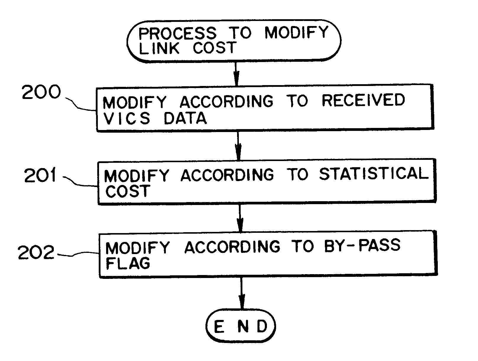
The navigation system wherein the present invention is applied uses the statistical cost obtained by practically investigating a congestion on a road as the cost of a road used in the route search. Therefore, the navigation system is characterized by performing the route search that accurately reflects the real circumstances of roads even outside the service area of the VICS. One embodiment of the navigation system will hereafter be described with the accompanying drawings.

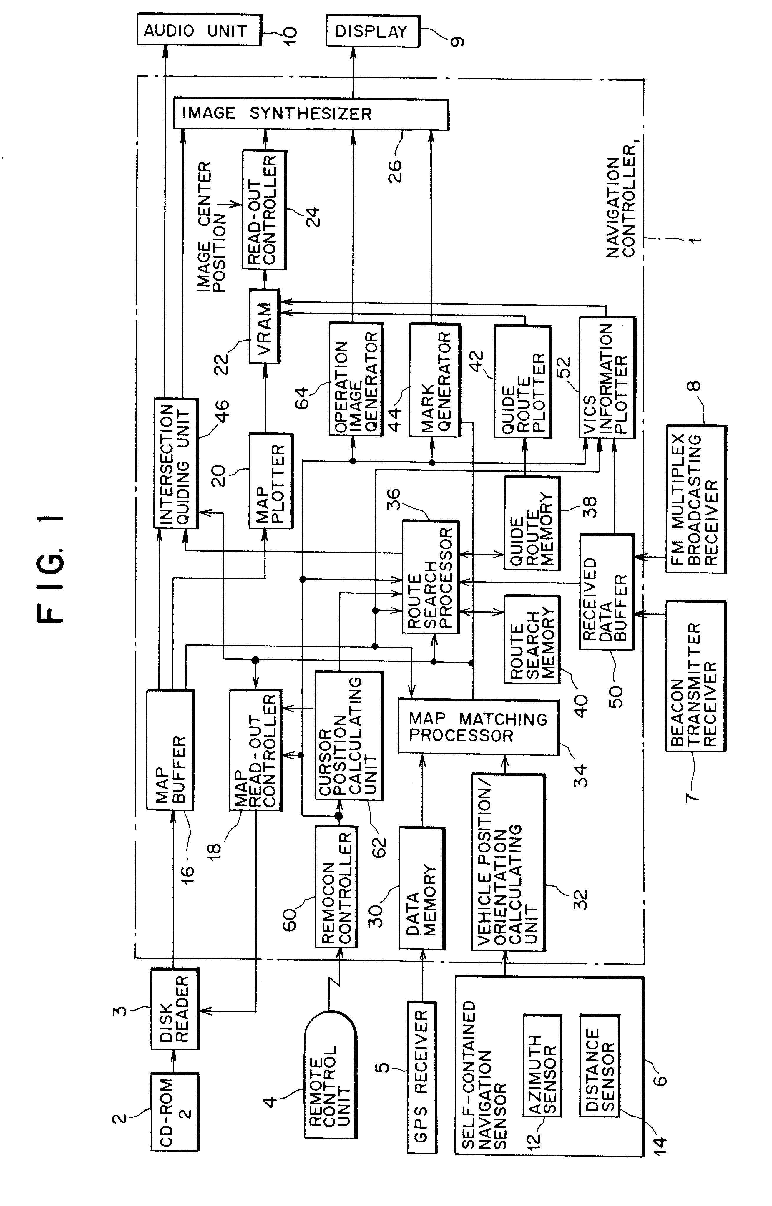
(1) TOTAL CONSTRUCTION OF THE NAVIGATION SYSTEM

FIG. 1 is a total block diagram of the car navigation system relating to the embodiment wherein the invention is applied. The navigation system shown in FIG. 1 contains a navigation controller 1 to control the whole system, a CD-ROM 2 wherein various map data necessary for displaying maps and for searching routes are recorded, a disk reader 3 to read out the map data recorded in the CD-ROM 2, a remote control unit 4 as an operation board through which a driver or an o...


PUM


Abstract

The invention provides a navigation system that is able to accurately calculate the cost during searching or guiding a route. The navigation controller of the navigation system is comprised of a map buffer that stores various data for displaying maps and searching routes, a route search processor for searching routes, a guide route memory, and a route search memory. When the search key of the remote control unit is pressed, the route search processor makes an intersection network list necessary for a route search between two intersections to store in the route search memory. Further, the route search processor modifies a link cost in the route search memory by replacing it with a statistical cost representing a statistically obtained time that is required for actually passing through the road link, and executes the route search on the basis of the modified cost data.

Description

1. Field of the InventionThe present invention relates to a navigation system that sets an optimum path to connect a start point to a destination by means of a route search.2. Description of the Related ArtGenerally, the car navigation system detects the present position of a car, reads out the map data near the position of the car from the CD-ROM, and illustrates it on the display. On the center of the display screen, a vehicle position marker is presented to indicate the position of the car. The adjoining map data is scrolled around this vehicle position marker as the car travels, so that the map information around the present position of the car can always be obtained.Usually, the car navigation system contains a route guiding function that enables a driver to travel to a desired destination without taking a wrong path. This route guiding function automatically searches, using a search layer data stored in the CD-ROM, a route of the lowest cost to connect from the start point to ...

Claims


Application Information

Patent Timeline
IPC IPC(8): G01C21/34G08G1/0968G01C21/00G09B29/00G06F17/30G08G1/0969
CPCG01C21/3492G08G1/096872G08G1/096861G08G1/096827
Inventor ICHIKAWA, SHIGERU
Owner ALPINE ELECTRONICS INC
Why Eureka
Try Eureka