Direct broadcast imaging satellite system apparatus and method for providing real-time, continuous monitoring of Earth from geostationary Earth orbit

a satellite system and satellite technology, applied in the field of direct broadcast imaging satellite system apparatus and method for providing real-time, continuous monitoring of earth from geostationary earth orbit, can solve the problems of satellite sensor looking an uneven portion of the earth's surface, significant earth-based events that occur during lapses in coverage of a particular region, and rare srso operations

Inactive Publication Date: 2003-01-07
ASTROVISION INT
View PDF4 Cites 12 Cited by
  • Summary
  • Abstract
  • Description
  • Claims
  • Application Information

AI Technical Summary

Problems solved by technology

In practice, SRSO operations are rarely used because coverage of other areas is too important to be neglected for long periods of time.
Moreover, significant Earth-based events that occur during lapses in coverage of a particular region may be missed.
In other words, the satellites sensor may be looking an uneventful portion of the Earth's surface when the significant activity is occurring at another portion of the Earth's surface.
Furthermore, as recognized by the present inventor, phenomena that may occur at night can only be seen in the infrared channels, which have a much coarser spatial resolution than the visible channel and otherwise are subject to the same limitations that are inherent in a scanning system.
GOES satellites provide a system that is optimized for monitoring cloud motion, but is far less suitable for observing other GEO physical events.
Color, enhancing the contrast and visibility of the Earth's surface background, may actually detract from cloud visibility in a scene.
Moreover, adding color may triple the amount of information and thus size of a digitized image, which creates a burden on the transmission demands for the broadcast portion of the satellite system.
Furthermore, observations of significant, but perhaps transient phenomena that occur in time scales of seconds or minutes (such as volcanoes, lightening strikes or meteors) may be late or not observed at all.
Accordingly, the information provided from systems like the GOES system is somewhat unreliable because it is not able to provide a high-resolution "watchdog" service that reliably reports real-time information over a significant portion of the Earth's surface.
Also, "video" style loops created from successive images having relatively coarse temporal resolution may lack the continuity needed to provide truly reliable information if cloud movements between image samples are much greater than a pixel dimension.
These effects have a significant adverse impact on the fidelity of any "image" created to represent the state of the Earth at a given moment, but particularly harmful to attempts to build animations using successive co-registered scanned images of a given area.
The European space agency's METEOSTAT-6 satellite, parked in a 0.degree. orbit, requires a license to decrypt and thus limits distribution for three days after observation.
As presently recognized, the system proposed by Hughes was deficient in both its camera resources and communication systems infrastructure with regard to the following three attributes.
The system proposed by Hughes did not provide real-time images (as defined herein) as a result of the delay between frames.
Another deficiency was that real-time images cannot be distributed in real-time, due to the interval between frames and the slow data rate, as well as the single point data reception and distribution facility.
Furthermore, the system proposed by Hughes was deficient in its inability to provide hemispheric (fill disk images) in real-time.
This limitation is due to the limited telemetry channel capacity, limited camera design and the time required to create a composite full disk image.
In this technique, every geographic scene element is sampled 128 times, which increases the signal-to-noise level.
However, communication satellites are relatively unstable platforms.
With a single pixel integration time on the order to milliseconds, spacecraft movement during the accumulation of over 100 samples may degrade the spatial resolution within any one scene element.
The continuity of successive observations will thus be compromised and degrade "seamless" coverage by an amount proportional to the velocities of the objects causing the shapes to apparently change.
Furthermore, the significance of obtaining real-time night images or the mechanisms needed to obtain the images was never appreciated, and thus not realized.
As presently recognized, limitation with the GATES system is that live images are not possible, nor is night imaging.
A limitation with the Hughes proposed system, the MITRE system, and the GATES system, is that none of the systems appreciate the interrelationship between providing a real-time continuous monitoring capability of the entire Earth that is accessible from a geostationary Earth orbit, while providing high resolution images.
In part, the limitation with all of the devices is that none of the devices would be able to reliably provide the "watchdog" high resolution imaging function that would provide a remote user with valuable real-time data of dynamic situations occurring at or near the Earth's surface.

Method used


Image

  • Direct broadcast imaging satellite system apparatus and method for providing real-time, continuous monitoring of Earth from geostationary Earth orbit
  • Direct broadcast imaging satellite system apparatus and method for providing real-time, continuous monitoring of Earth from geostationary Earth orbit
  • Direct broadcast imaging satellite system apparatus and method for providing real-time, continuous monitoring of Earth from geostationary Earth orbit

Examples


Embodiment Construction

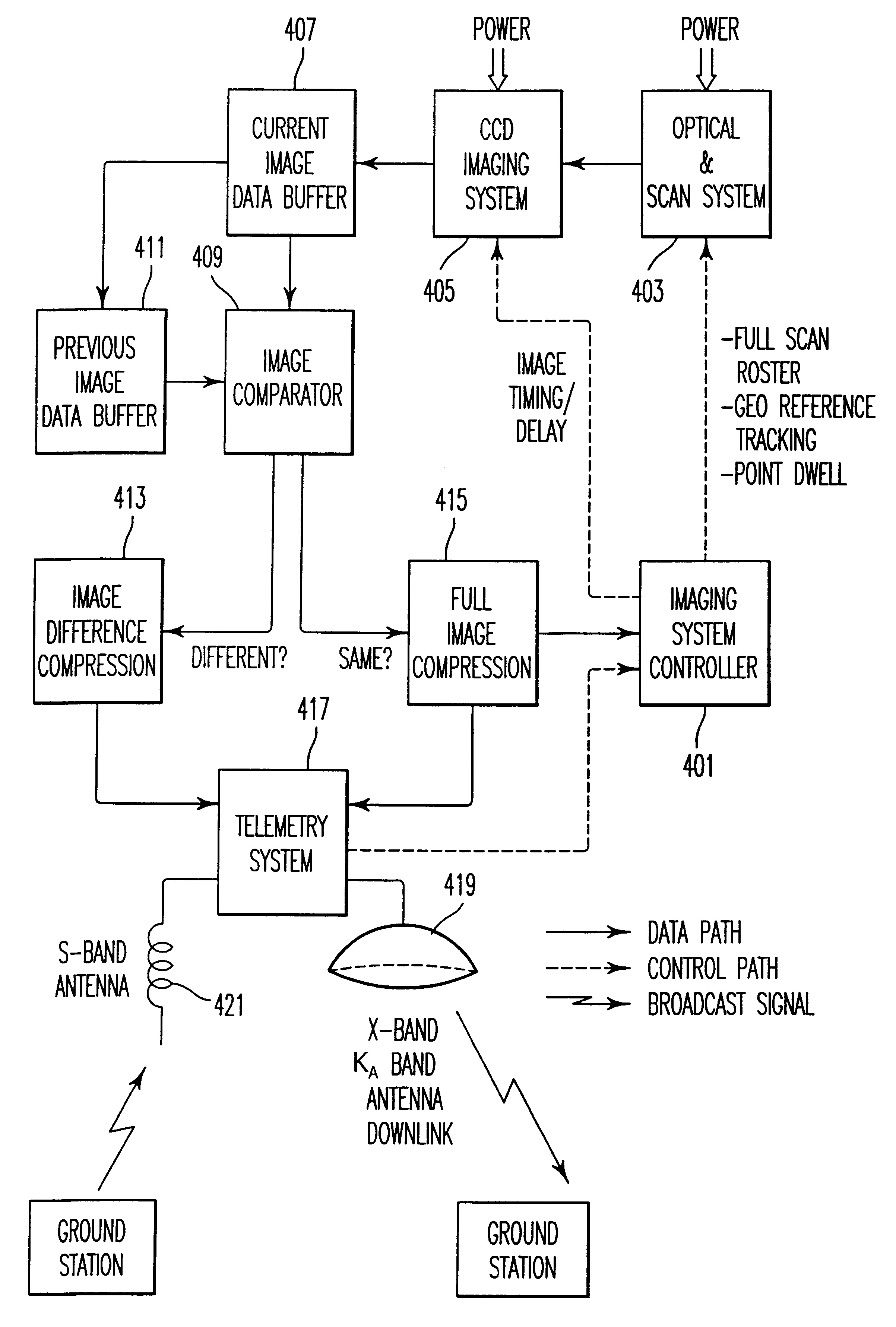
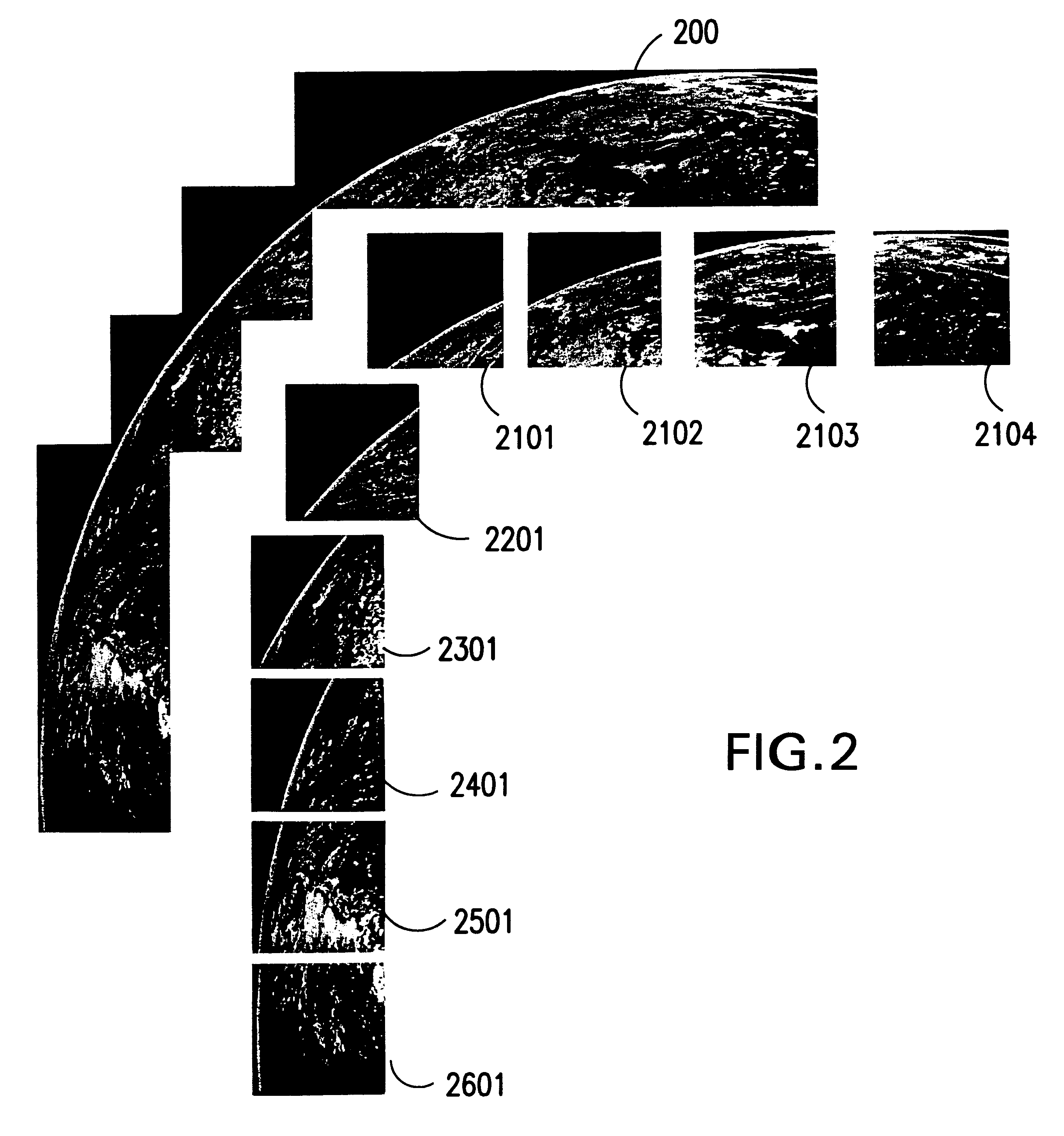
Over the past 40 years since the first Sputniks and 30 years after the first weather monitoring satellite was placed in GEO, exploration of the Earth from space remains incomplete and inadequate. As of yet, there exists insufficient mechanisms to observe and study all of the processes that occur day or night and on or near the Earth's surface that may influence life on our planet. Furthermore, there is presently no capability to monitor the entire surface in real-time as a global system and to distribute that data to all parts of the Earth in real-time. The present method, apparatus and system described herein is aimed to provide a comprehensive, simultaneous and real-time observation platform of the Earth's global environment and offer the information gathered from that perspective to a global audience. Accordingly, the coverage is made at temporal and spatial scales and resolutions configured to capture events on Earth that may possibly change over relatively short periods of time...


PUM


Abstract

A system, method and apparatus for collecting an distributing real-time, high resolution images of the Earth from GEO include an electro-optical sensor based on multi-megapixel two-dimensional charge coupled device (CCD) arrays mounted on a geostationary platform. At least four, three-axis stabilized satellites in Geostationary Earth orbit (GEO) provide worldwide coverage, excluding the poles. Image data that is collected at approximately 1 frame / sec, is broadcast over high-capacity communication links (roughly 15 MHZ bandwidth) providing real-time global coverage of the Earth at sub-kilometer resolutions directly to end users. This data may be distributed globally from each satellite through a system of space and ground telecommunication links. Each satellite carries at least two electro-optical imaging systems that operate at visible wavelengths so as to provide uninterrupted views of the Earth's full disk and coverage at sub-kilometer spatial resolutions of most or selected portions of the Earth's surface.

Description

BACKGROUND OF THE INVENTION1. Field of the InventionThe present invention relates to methods and systems for making global observations of the Earth at sub-kilometer spatial resolutions in real-time, where real-time refers to a delay of not more than two minutes total for creating, refreshing and distributing each image. More particularly, the present invention is directed towards methods, apparatuses and systems that provide real-time coverage of at least 70% of the observable Earth surface at a spatial resolution of less than 1 kilometer.2. Discussion of the BackgroundOver the last 30 years, since the first weather monitoring satellite was placed in geostationary earth orbit (GEO), various satellite systems have been used to monitor features of the Earth. The reason is that at GEO the relative motion of the Earth and the satellite is nulled, provided that the GEO orbit is in the Earth's equatorial plane. Accordingly, consistent images may be taken of the portion of the Earth's sur...

Claims


Application Information

Patent Timeline
Patent Type & Authority Patents(United States)
IPC IPC(8): G01C11/02G01C11/00
CPCG01C11/025
Inventor LECOMPTE, MALCOLM A.
Owner ASTROVISION INT
Why Eureka
Try Eureka