Satellite and ground system for detection and forecasting of earthquakes

a satellite and ground technology, applied in the field of satellite and ground system for detection and forecasting of earthquakes, can solve the problems of impracticality and/or cost, and achieve the effect of reducing cost and manpower needed

Inactive Publication Date: 2005-03-29
STELLAR SOLUTIONS
View PDF15 Cites 159 Cited by
  • Summary
  • Abstract
  • Description
  • Claims
  • Application Information

AI Technical Summary

Benefits of technology

One aspect of the present invention is the use of a space based ELF magnetic detector in conjunction with a ground based ELF magnetic detector. For example, a space based detection system can be used to perform a wide area search and find precursor earthquake signals in both known and unknown earthquake zones, and a ground based detection system can be used to verify that the signals are indeed earthquake generated signals. The use of this invention will minimize cost and manpower necessary to effectuate an accurate and reliable earthquake detection system.
The benefits of a combination ground and space system are substantial. The space part of the system provides early detection for a large region and the ground part of the system provides for reliable verification and constant monitoring of the ELF fluctuations.

Problems solved by technology

As discussed above, it is impractical and / or costly to have ground detectors covering expansive regions.

Method used


Image

  • Satellite and ground system for detection and forecasting of earthquakes
  • Satellite and ground system for detection and forecasting of earthquakes
  • Satellite and ground system for detection and forecasting of earthquakes

Examples


Embodiment Construction

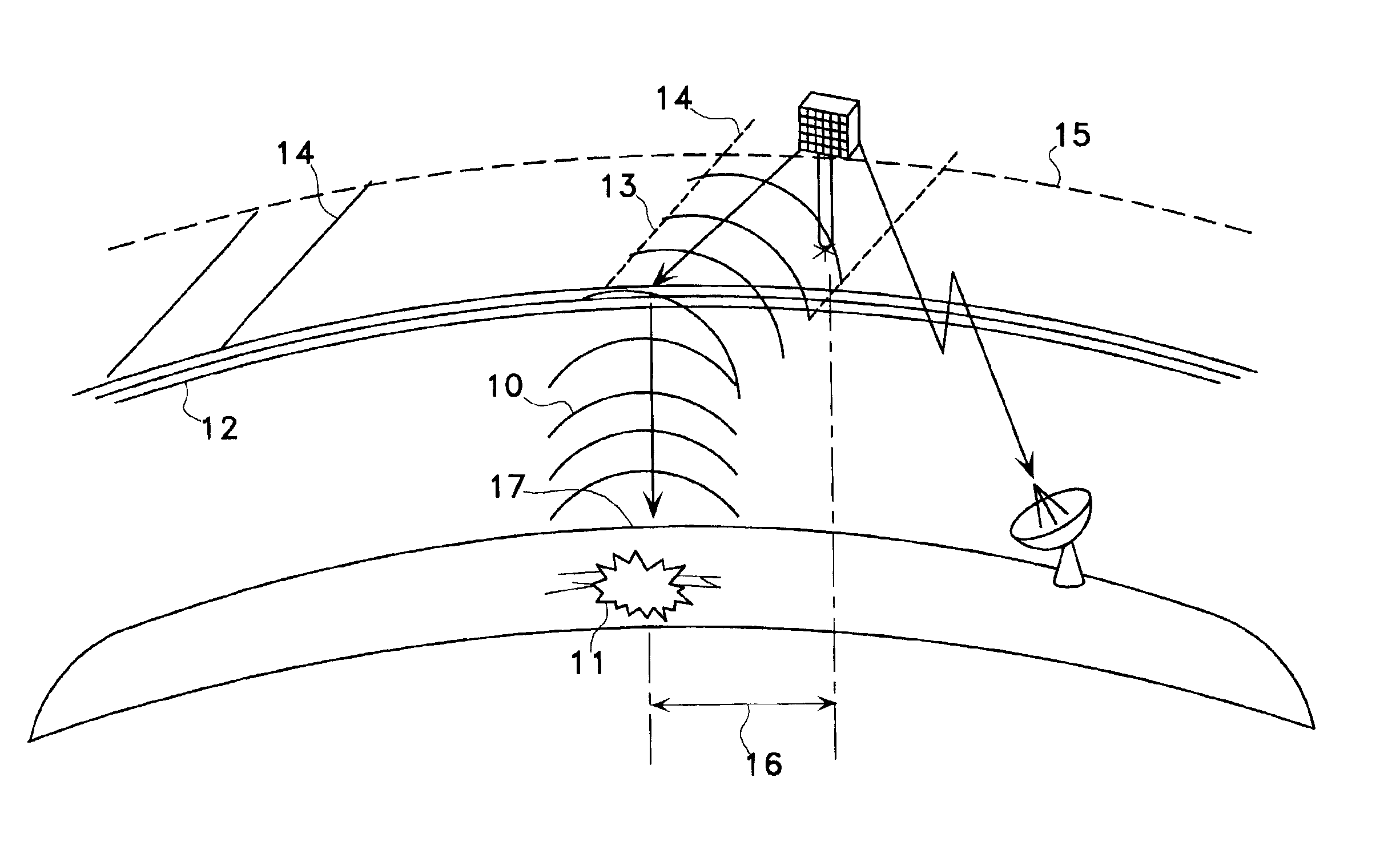
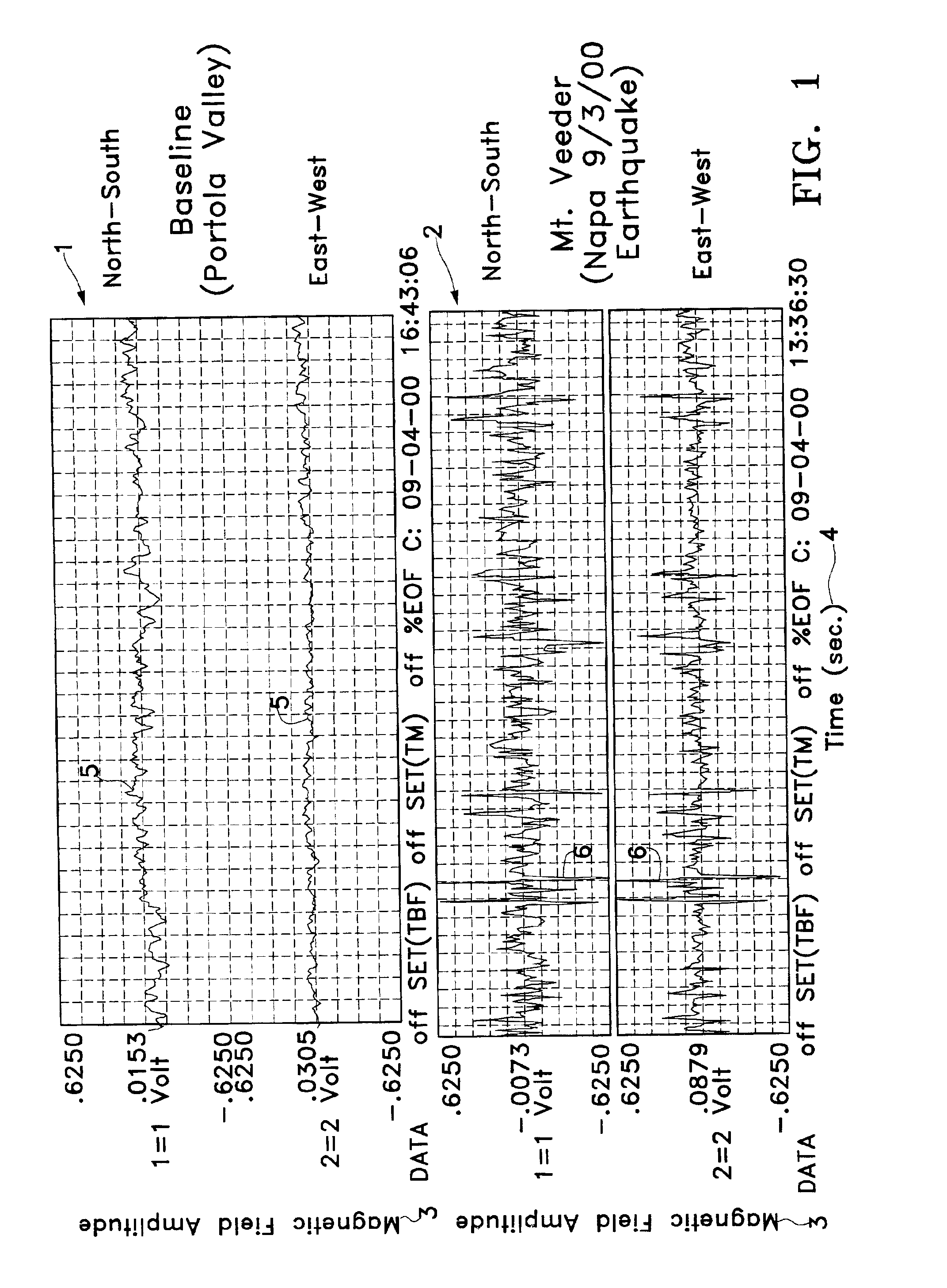
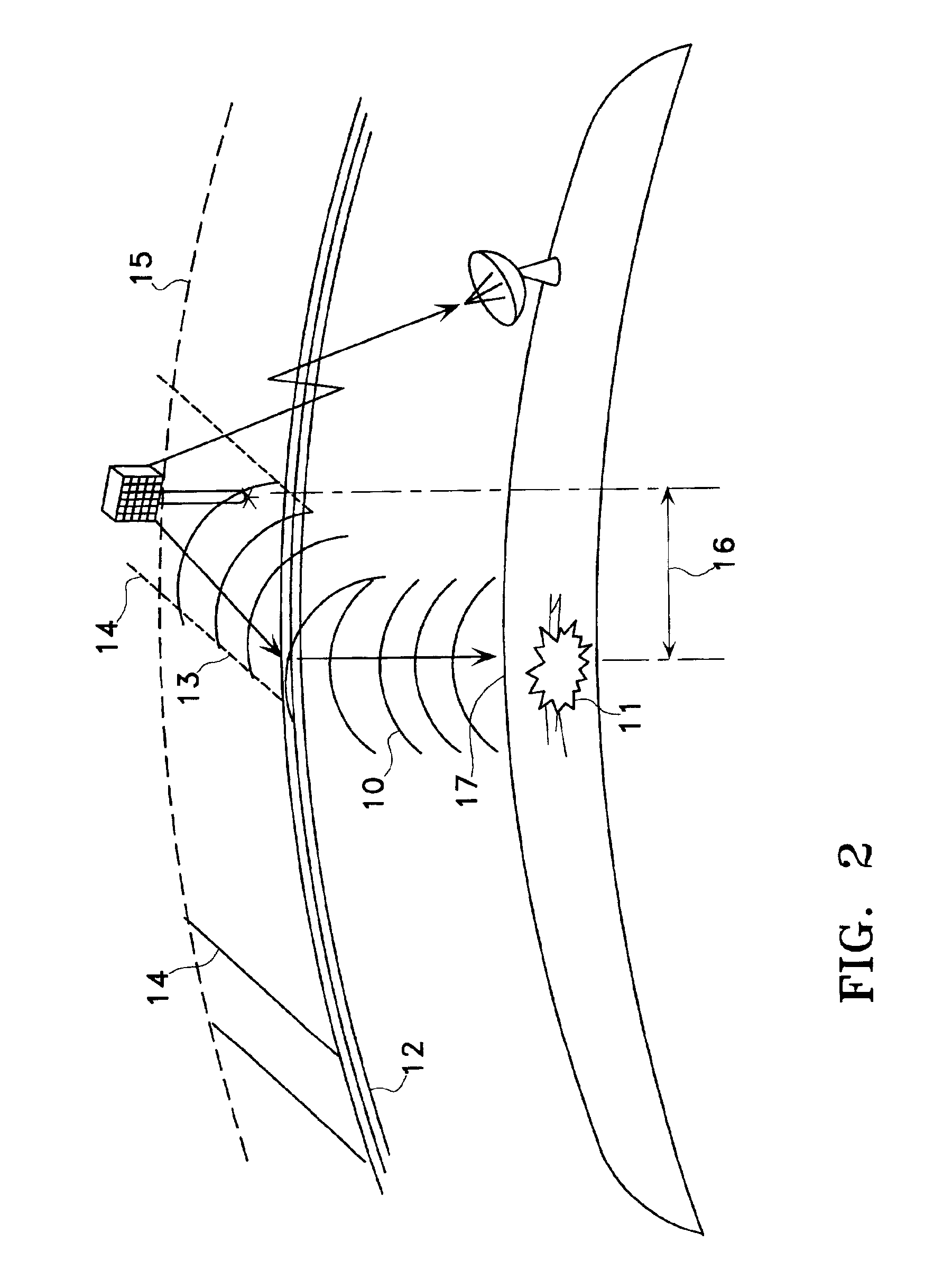
For purposes of this disclosure, ELF generally refers to the frequency range of the electromagnetic spectrum greater than 0 to about 500 Hz, and in this context, specifically refers to the frequency range of the magnetic field fluctuations detected by the ground-based and space-based signals emanating from an earthquake-ready site. The Graphs (1) and (2) in FIG. 1. illustrate ELF signals. The first graph (1) depicts baseline measurements taken in Portola Valley, Calif. The second graph (2) shows data taken with the same sensor, on the same day, at the epicenter of a Richter magnitude 5.2 earthquake in Napa, Calif. The top half of both graphs (1) and (2) show data taken from North-South antenna coils, and the bottom half show data taken from East-West antenna coils. The Y-axis (3) is the magnetic field amplitude, measured in volts at the output of the sensor. The X-axis (4) shows time, with each box representing 1 second of time (40 seconds total across the page). The baseline signat...


PUM


Abstract

The present invention describes the use of a space-based Extremely Low Frequency (ELF) magnetic field detector in conjunction with ground-based network of ELF magnetic field detectors. In particular, a space based ELF detection system can be used to perform a wide area search and find precursor earthquake signals in both known and unknown earthquake zones, and a ground-based network of ELF detectors can be used to verify that the signals are indeed earthquake generated signals. The use of this invention will minimize cost and manpower necessary to effectuate an accurate and reliable earthquake detection system.

Description

TECHNICAL FIELDThe present invention relates generally to earthquake monitoring and forecasting. More particularly, the invention relates to a satellite and ground-based system and method of using a satellite and ground based system to accurately and reliably forecast areas likely to be affected by an earthquake in the near future.BACKGROUND ARTEarthquake forecasting has the potential to save thousands of lives and billions of dollars in property damage. Accurate earthquake forecasting can give inhabitants of a pending earthquake area time to prepare and minimize the loss of life and property damage.Unfortunately, the reliable forecasting of earthquakes has so far eluded scientists, as no one has yet developed an accurate system or method for determining when an earthquake will occur and how devastating it will be. Currently, one method of forecasting earthquakes uses statistics of recent earthquakes in a known earthquake region. The more recent an earthquake has occurred, the less ...

Claims


Application Information

Patent Timeline
Patent Type & Authority Patents(United States)
IPC IPC(8): G01V1/00G01V3/12
CPCG01V3/12G01V1/008
Inventor BLEIER, THOMAS E.
Owner STELLAR SOLUTIONS
Why Eureka
Try Eureka