
Method and system for using real-time traffic broadcasts with navigation systems

a traffic broadcast and navigation system technology, applied in the field of system and method for using real-time broadcasts of traffic and road conditions in the navigation system, can solve the problems of system, data in traffic broadcast system reports, and lack of connection with navigation system data

Inactive Publication Date: 2006-04-18
HERE GLOBAL BV
View PDF19 Cites 114 Cited by
  • Summary
  • Abstract
  • Description
  • Claims
  • Application Information

AI Technical Summary

Benefits of technology

[0012]Another aspect of a present embodiment includes the formation, storage, and use of one or more indices that relate location refere

Problems solved by technology

Unfortunately, the data in the reports broadcast by traffic broadcast systems, su

Method used


Image

  • Method and system for using real-time traffic broadcasts with navigation systems
  • Method and system for using real-time traffic broadcasts with navigation systems
  • Method and system for using real-time traffic broadcasts with navigation systems

Examples


example 1

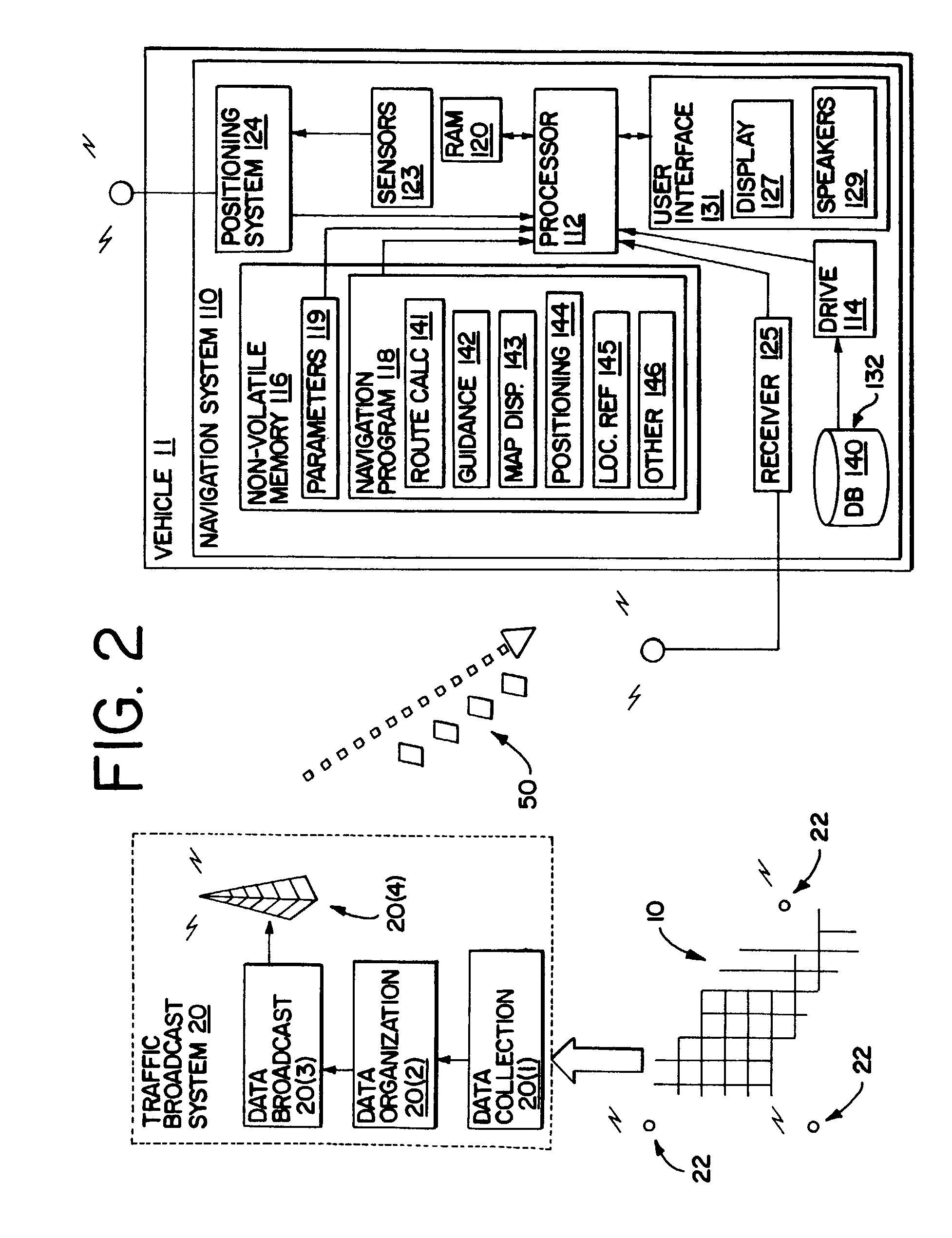
[0140]This example is described in connection with FIG. 15. In the example of FIG. 15, traffic data are obtained at initialization of the navigation system and then updated continuously or at regular intervals during use of the navigation system. In FIG. 15, at or after the navigation system is started or initialized (Step 807), a traffic data collection program 810 is executed. This traffic data collection program 810 may be part of the navigation application programming 118, the interface layer programming (mentioned above), or any other part of the navigation system. The traffic data collection program 810 may work in the background so that it does not interfere with other tasks that the end-user may call on the navigation system to perform.

[0141]The traffic data collection program 810 begins to receive traffic message broadcasts 50. These may be received from the receiver 125 in FIG. 2. For each traffic message 50 received, the traffic data collection program 810 calls the locat...

example 2

[0145]This example is described in connection with FIG. 16. In FIG. 16, traffic data 50 are not obtained until the route calculation program 141 is run. In FIG. 16, the route calculation program 141 receives input that includes a desired destination and an origin (Step 901). A traffic data collection program 903 is called. This traffic data collection program 903 obtains traffic messages 50 broadcast by the traffic broadcast system 20 (Step 905). Each of these traffic messages may be temporarily stored in a memory of the navigation system 110. The traffic messages 50 may be filtered so that messages that pertain to locations relatively far away from potential solution routes are not processed. Then, the traffic data collection program 903 executes a routine 907 for each pertinent traffic message.

[0146]For each traffic message 50, the routine 907 calls the location reference routine 145 (in FIG. 14) in order to obtain all the segment data entities (or at least the ID's for all the se...


PUM


Abstract

A system and method are disclosed that allow a navigation system that uses a geographic database to also use the data in traffic messages broadcast by a traffic broadcast system. One aspect of a present system and method includes the formation, storage, and use of location reference data records in a geographic database used by a navigation system. These location reference data records identify certain other kinds of data records that represent physical geographic features, such as data records that represent segments of roads, as being associated with certain location reference numbers. These location reference records may be included in a geographic database installed in the vehicle or may be provided to vehicles via a wireless communication link. Another aspect of a present system and method includes the formation, storage, and use of one or more indices that relate location reference numbers used by a traffic broadcast system to location reference records in a geographic database used by the navigation system. Another aspect of a present system and method is the formation, storage, and use of data that identify, for each location reference number, the immediately previous and the immediately next location reference number. Still another aspect of a present system and method includes the programming, and methods of use thereof, that query the geographic database and return the data entities associated with certain identified location reference numbers.

Description

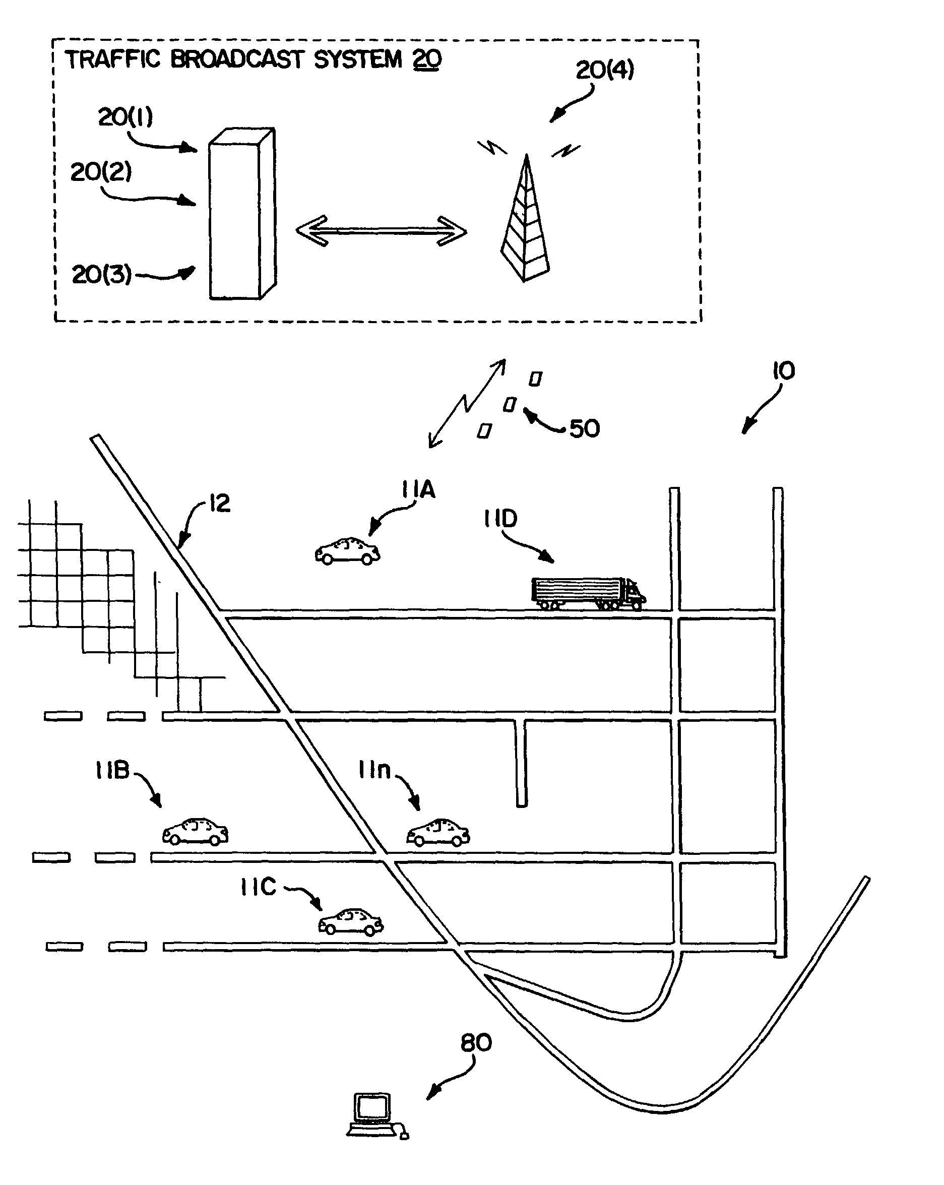
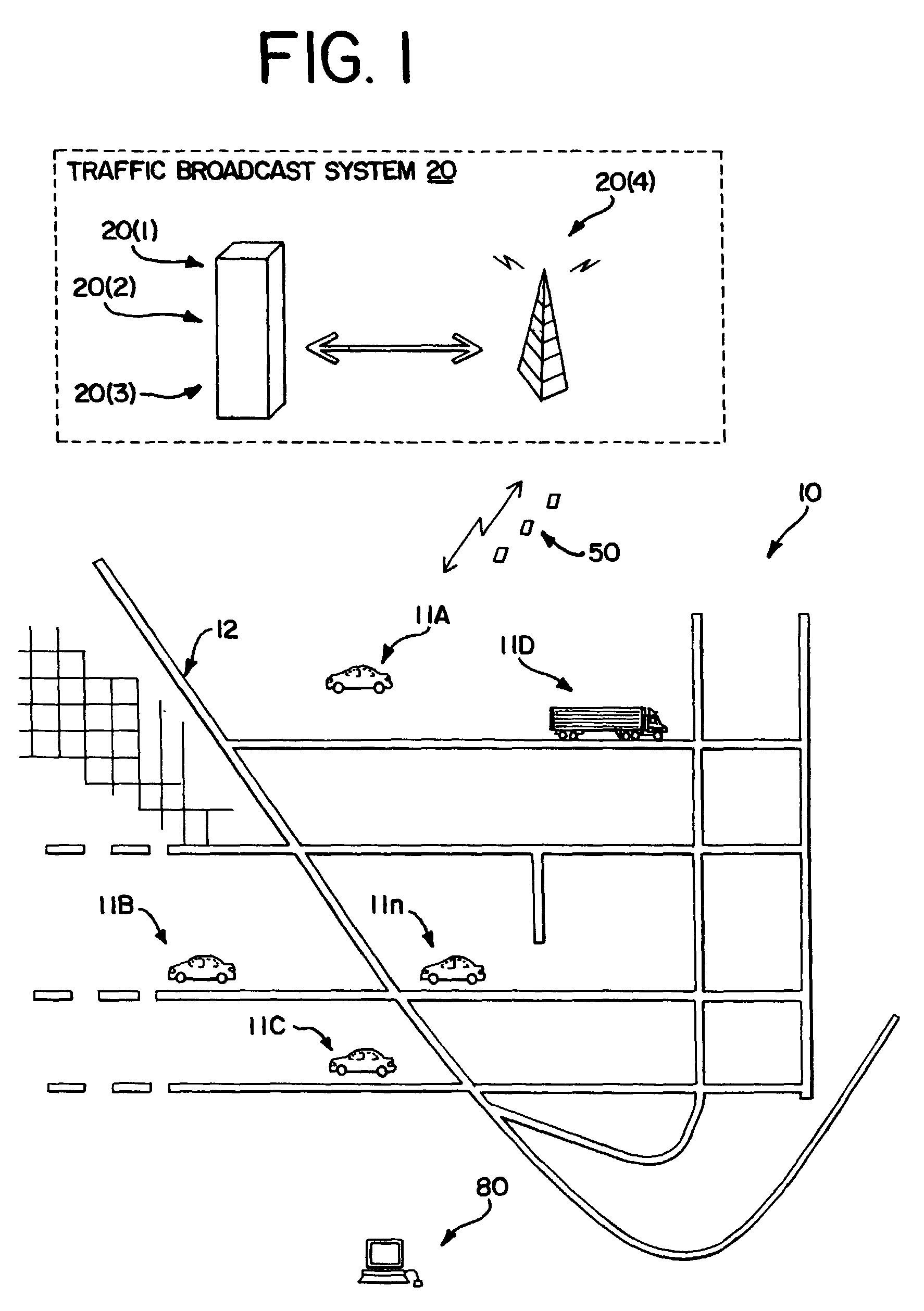
REFERENCE TO RELATED APPLICATIONS[0001]The present application is a continuation of Ser. No. 09 / 196,409, filed Nov. 19, 1998 now U.S. Pat. No. 6,438,561 the entire disclosures of the aforementioned documents are incorporated herein by reference.BACKGROUND OF THE INVENTION[0002]The present invention relates to a system and method for using real-time broadcasts of traffic and road conditions in a navigation system, and more particularly, the present invention relates to a system and method that facilitates and implements the use and coordination of traffic broadcast data in a navigation system that uses a geographic database.[0003]In some regional and metropolitan areas and countries, systems have been implemented that broadcast up-to-the-minute reports of traffic and road condition information. These systems broadcast traffic and road condition information on a continuous, periodic, or frequently occurring basis. These broadcasts can be received by receivers installed on-board vehicl...

Claims


Application Information

Patent Timeline
IPC IPC(8): G06F17/30G01C21/00G09B29/00G01C21/34G08G1/09G08G1/0968G08G1/0969G09B29/10
CPCG01C21/3492G08G1/096827G08G1/096866G08G1/096872Y10S707/92Y10S707/99933Y10S707/99945Y10S707/99948
Inventor ISRANI, VIJAYA S.FERNEKES, ROBERTASHBY, RICHARD A.LAMPERT, DAVIDJAUGILAS, JOHN M.
Owner HERE GLOBAL BV
Learn More