Using embedded steganographic identifiers in segmented areas of geographic images and characteristics corresponding to imagery data derived from aerial platforms

a technology of geographic images and steganographic identifiers, applied in the field of image management and processing, can solve the problems of managing and coordination of the resulting large data sets, and the problem of efficiently updating “stale” imagery

Inactive Publication Date: 2006-05-09
DIGIMARC CORP
View PDF121 Cites 91 Cited by
  • Summary
  • Abstract
  • Description
  • Claims
  • Application Information

AI Technical Summary

Benefits of technology

[0005]The quality of the imagery has also constantly improved. Some satellite systems are now capable of acquiring image and topological data having a resolution of less than a meter. Aircraft imagery, collected from lower altitudes, provides still greater resolution.
[0009]In accordance with one aspect of the present invention, digital watermarking technology is employed to help track such imagery, and can also provide audit trail, serialization, anti-copying, and other benefits.

Problems solved by technology

Management and coordination of the resulting large data sets is a growing problem.
Integrating the imagery with related, often adjacent, imagery, and efficiently updating “stale” imagery is also a problem.

Method used


Image

  • Using embedded steganographic identifiers in segmented areas of geographic images and characteristics corresponding to imagery data derived from aerial platforms
  • Using embedded steganographic identifiers in segmented areas of geographic images and characteristics corresponding to imagery data derived from aerial platforms
  • Using embedded steganographic identifiers in segmented areas of geographic images and characteristics corresponding to imagery data derived from aerial platforms

Examples


Embodiment Construction

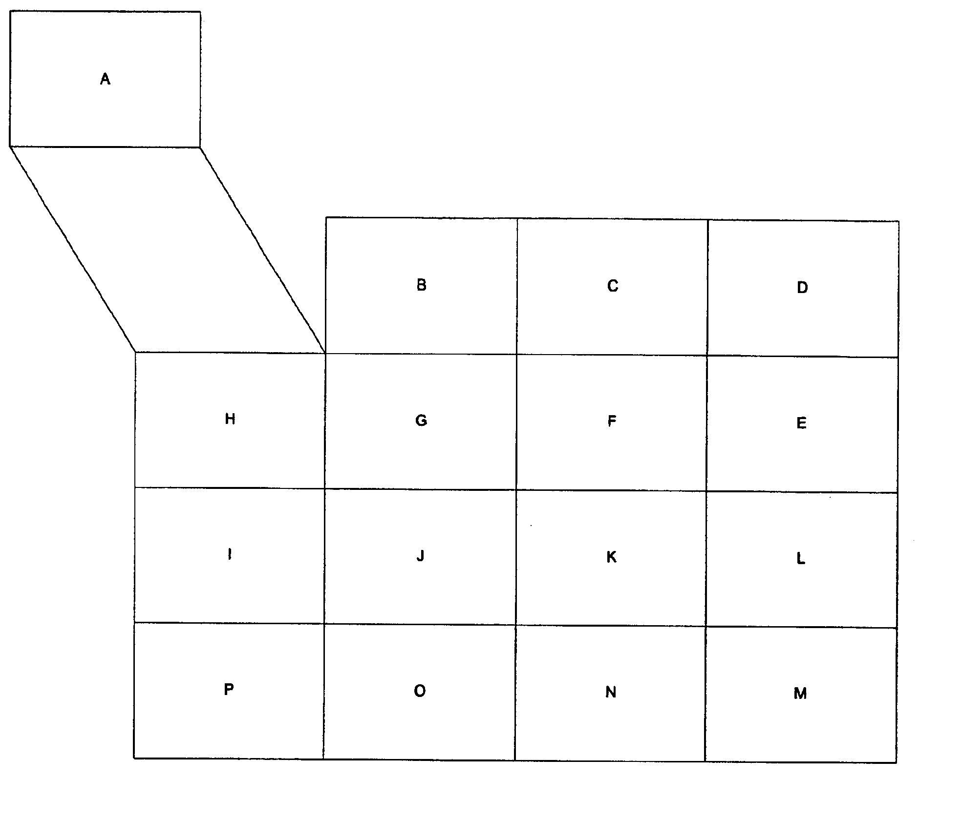
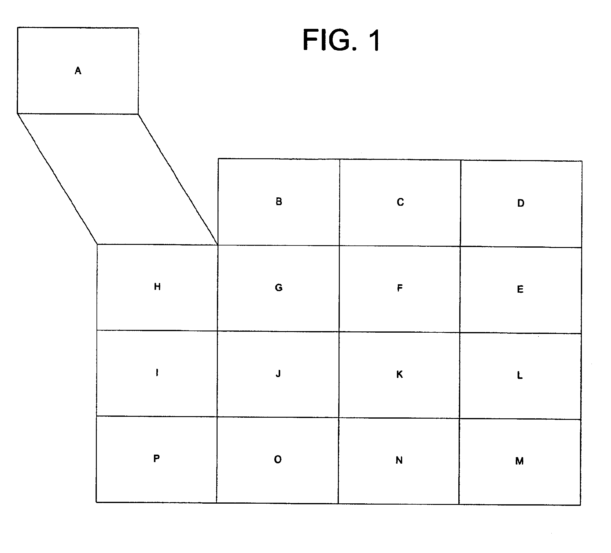
[0017]For expository convenience, the following section focuses on satellite and aerial “imagery” to illustrate the principles of the invention. The principles of the invention, however, are equally applicable to other forms of aerial surveillance data and other topographic / mapping information. Accordingly, the term “image” should be used to encompass all such other data sets, and the term “pixel” should be construed to encompass component data from such other data sets.

[0018]When new aerial imagery is received, it is generally necessary to identify the precise piece of earth to which it corresponds. This operation, termed “georeferencing” or “geocoding,” can be a convoluted art and science.

[0019]In many systems, the georeferencing begins with a master reference system (e.g., latitude and longitude) that takes into account the earth's known deformities from a sphere. Onto this reference system the position of the depicted region is inferred, e.g., by consideration of the satellite's...


PUM


Abstract

Digital watermarking technology is used in conjunction with map data, such as is acquired by satellite and other aerial sensors. The watermarks are used to track metadata, provide serialization and forensic tracking, help auto-correlate image data, and quilt together related imagery. One aspect of the present invention contemplates that incoming imagery is automatically geo-referenced and combined with previously collected data sets so as to facilitate generation of revised composite maps. Another aspect of the present invention associates geovector information with a photograph via a digital watermark.

Description

RELATED APPLICATION DATA[0001]This patent application is a continuation-in-part of U.S. patent application Ser. No. 09 / 800,093, titled “Geo-Referencing of Aerial Imagery Using Embedded Image Identifiers and Cross-Referenced Data Sets,” filed Mar. 5, 2001. This patent application also claims the benefit of U.S. Provisional Application Nos. 60 / 284,163, filed Apr. 16, 2001, titled “Watermark Systems and Methods,” and Ser. No. 60 / 284,776, filed Apr. 18, 2001, titled “Using Embedded Identifiers with Images.” Each of these patent applications is hereby incorporated by reference.FIELD OF THE INVENTION[0002]The present invention relates to image management and processing, and is particularly illustrated in the context of management of satellite and other aerial imagery.BACKGROUND AND SUMMARY OF THE INVENTION[0003]Acquisition of aerial imagery traces its history back to the Wright brothers, and is now commonly performed from satellite and space shuttle platforms, in addition to aircraft.[000...

Claims


Application Information

Patent Timeline
Patent Type & Authority Patents(United States)
IPC IPC(8): G09G5/00G06K9/00G01C11/00G01C13/00G06T1/00
CPCG01C11/00G06F17/30241G06T1/0021G06T2201/0061G06T2201/0051G06F16/29
Inventor RHOADS, GEOFFREY B.LOFGREN, NEIL E.
Owner DIGIMARC CORP
Why Eureka
Try Eureka