Al technical title is built by PatSnap Al team. It summarizes the technical point description of the patent document.
a navigation system and electronic technology, applied in the field of electronic navigation system and method, can solve the problems of cost, widespread use, maintenance and currency of the database, and still need a trade-off between cost and fast, efficient data access, maintenance and currency, so as to achieve the effect of increasing the amount of information available at a remote uni
Inactive Publication Date: 2006-05-23
HERE GLOBAL BV
View PDF53 Cites 29 Cited by
Summary
Abstract
Description
Claims
Application Information
AI Technical Summary
This helps you quickly interpret patents by identifying the three key elements:
Problems solved by technology
Method used
Benefits of technology
[0018]The tokenized forms are expanded at the remote unit into textual driving instructions for each of one or more languages. In addition, the amount of information availabl
Problems solved by technology
Autonomous route guidance systems have many drawbacks, however, which have prevented their widespread use.
Technologies such as CD-ROM have allowed storage of an entire database but require still a tradeoff between cost and fast, efficient data access.
Another problem with autonomous route guidance systems is maintenance and currency of the database.
As new streets are built, or as old streets are reconfigured, as businesses and other points of interest open and close, the database on CD-ROM or other media becomes out of date.
In addition, when a database is compiled, it may include errors which are then replicated in the many copies provided to users.
These errors may require correction in the user copies by replacing those database copies.
Moreover, incorrect or outdated information in the database can lead to errors when calculating routes.
When an out-of-date database does not include the information that a particular roadway is closed, the system may be unable to calculate an alternate rout
Method used
Image
Click on the blue label to locate the original text in one second.
Reading with bidirectional positioning of images and text.
Examples
Embodiment Construction
Overview
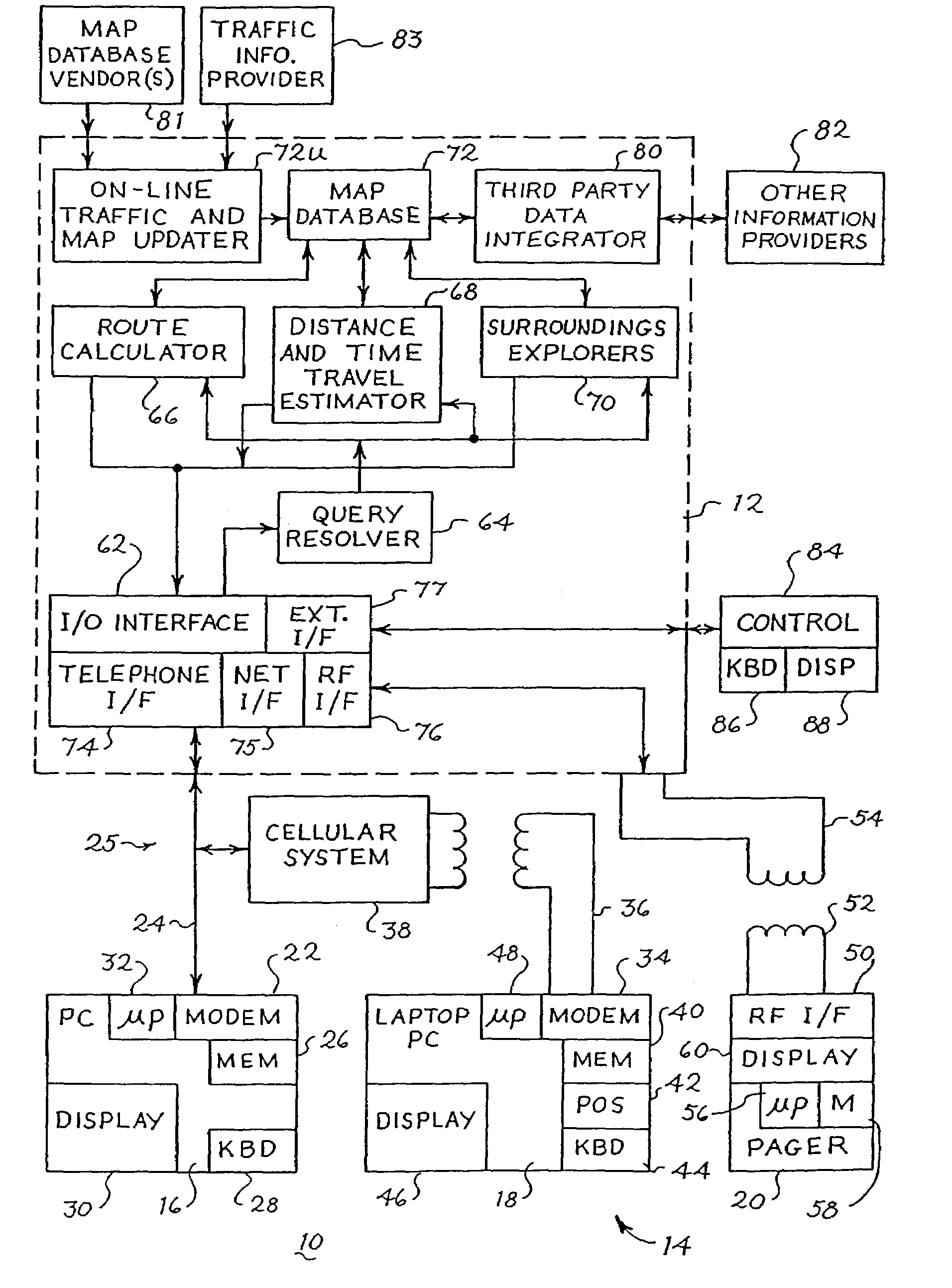
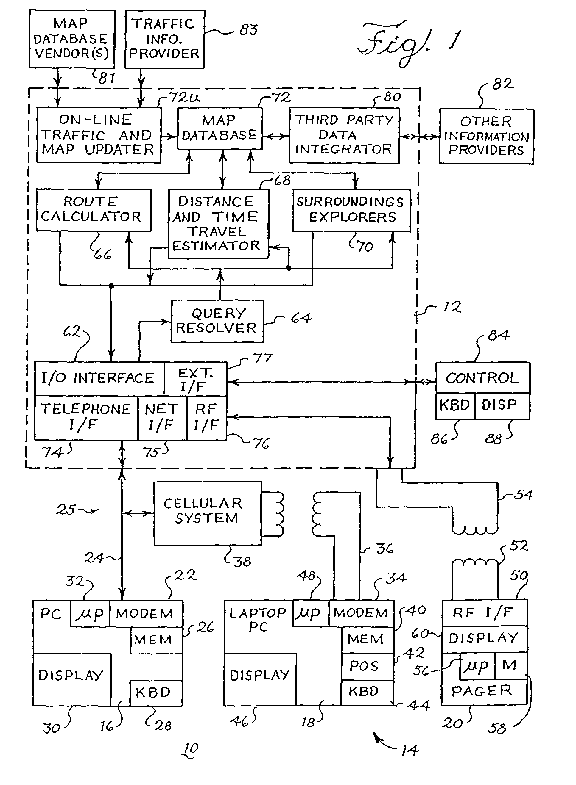
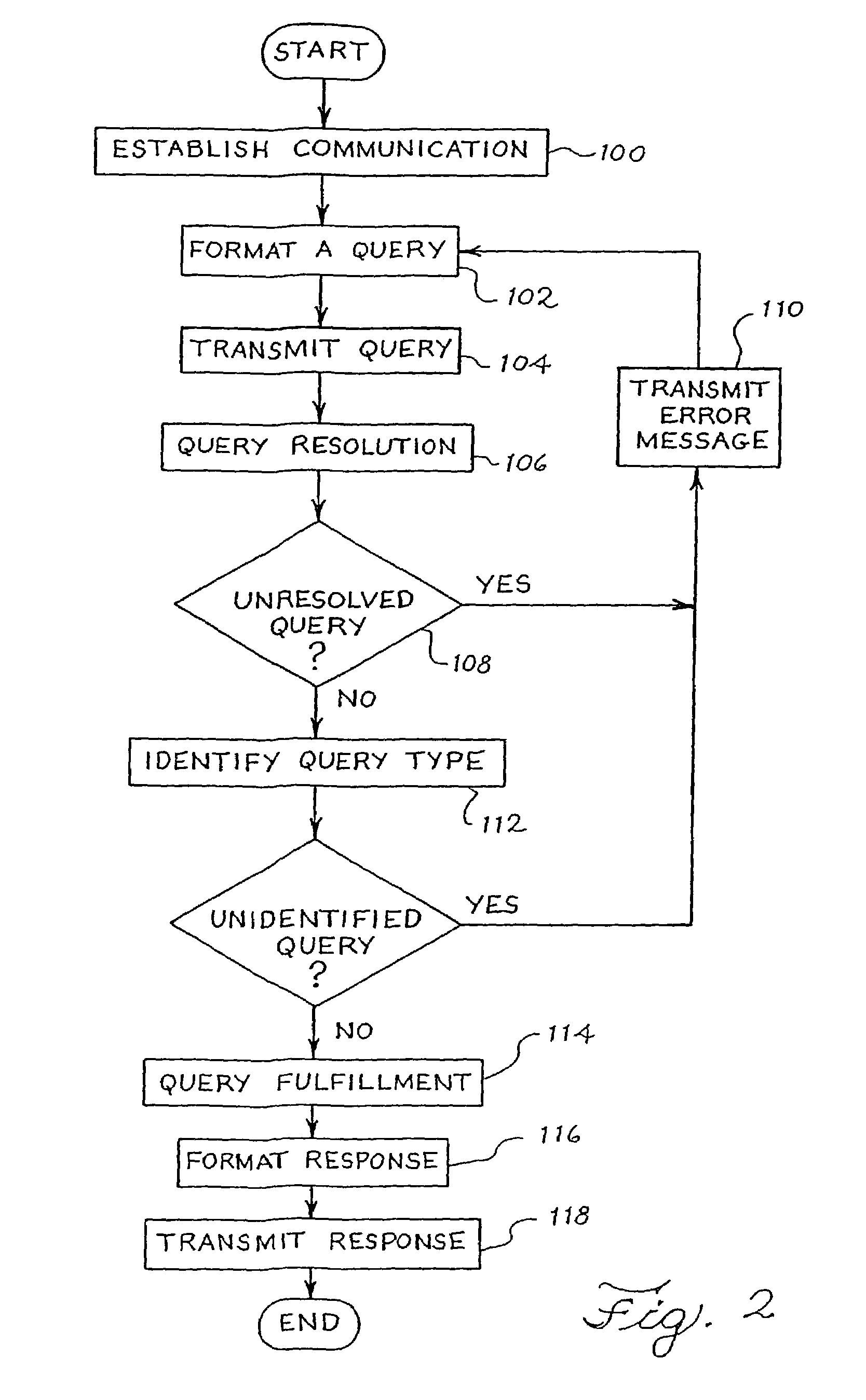
[0032]The invention provides a method of providing route guidance information and other information from a base unit to a mobile unit in response to a request from the mobile unit. The method comprises the steps of formatting a query at the mobile unit, the query including the request, communicating the query from the mobile unit to the base unit, and calculating route guidance information at the base unit in response to the query. The method further comprises the steps of formatting a response to the query at the base unit, the response including route guidance information, and communicating the response from the base unit to the mobile unit. The guidance information may include navigation instructions from an origin to a destination, information about one or more points of interest within a particular region, or other geographically referenced information.
[0033]The invention further provides a system for communicating routing information between a base unit and a mobile un...
PUM
Abstract
The invention provides a method and system for providing route guidance and other information from a base unit to a remote unit in response to a request from the remote unit. A query is formatted at the remote unit, the query including the request, and is transmitted from the remote unit to the base unit. Requested route guidance information is calculated at the base unit in response to the query, using a large up-to-date database located at the base unit. A response to the query is formatted at the base unit, the response including route guidance information. The response is then transmitted from the base unit to the remote unit for display. The transmission is made in a compact form through the use of maneuver arms and combined maneuver arms and through the use of tokenized forms. A maneuver arm represents a road at an intersection, for depiction on a display, by one or two endpoint coordinates. The tokenized forms are expanded at the remote unit into textual driving instructions for each of one or more languages. In addition, the amount of information available at a remote unit can be increased by providing the remote unit with information from the base unit which is not adequately covered by any databases on-board the remote unit.
Description
REFERENCE TO RELATED APPLICATIONS[0001]The present application is a divisional of Ser. No. 09 / 572,877 filed May 18, 2000; now U.S. Pat. No. 6,614,363, which was a continuation of Ser. No. 09 / 151,255 filed Sep. 10, 1998, now U.S. Pat. No. 6,107,944; which was a continuation of Ser. No. 08 / 494,198, filed Jun. 23, 1995, now U.S. Pat. No. 5,808,566, which was a continuation-in-part of Ser. No. 08 / 265,094, filed Jun. 24, 1994, now U.S. Pat. No. 5,543,789.[0002]A portion of the disclosure of this patent document contains material which is subject to copyright protection. The copyright owner has no objection to the facsimile reproduction by anyone of the patent document or the patent disclosure, as it appears in the Patent and Trademark Office patent file or records, but otherwise reserves all copyright rights whatsoever.BACKGROUND OF THE INVENTION[0003]The invention relates generally to a system and method for providing route guidance and tracking information and other information from a ...
Claims
Application Information
Patent Timeline
Application Date:The date an application was filed.
Publication Date:The date a patent or application was officially published.
First Publication Date:The earliest publication date of a patent with the same application number.
Issue Date:Publication date of the patent grant document.
PCT Entry Date:The Entry date of PCT National Phase.
Estimated Expiry Date:The statutory expiry date of a patent right according to the Patent Law, and it is the longest term of protection that the patent right can achieve without the termination of the patent right due to other reasons(Term extension factor has been taken into account ).
Invalid Date:Actual expiry date is based on effective date or publication date of legal transaction data of invalid patent.