Electromagnetic surveying for hydrocarbon reservoirs

a hydrocarbon reservoir and electromagnetic surveying technology, applied in the field of seafloor electromagnetic surveying, can solve the problems of inability to collect survey data highlighting only galvanic contributions in end-on geometry, and the previously proposed electromagnetic survey methods for finding hydrocarbon reservoirs are at best highly unreliabl

Inactive Publication Date: 2006-10-24
STATOIL ASA PETRO SA (NO)
View PDF11 Cites 113 Cited by
  • Summary
  • Abstract
  • Description
  • Claims
  • Application Information

AI Technical Summary

Benefits of technology

[0016]The method of the second aspect of the invention thus differs from that of the first aspect in that a single detector can be used to collect both the end-on and broadside survey data. This can be done by towing the source twice, once in a direction along the line connecting the source to the detector, and again in a direction transverse thereto. Namely, the first and second survey data sets can be obtained consecutively. The relative alignment between the source and detector when the end-on and broadside survey data are collected can be varied in the same way as discussed above in relation to the first aspect of the invention. In other words, it is best if the dipole is aligned along a line connecting the source and detector when the end-on survey data is collected, and aligned perpendicular to that line when the broadside survey data is collected. However, deviations from that condition will occur and can be tolerated.
[0028]The model should preferably include a body of air above the body of water, so that the simulation can take account of signal propagation paths including the body of air when calculating the first and second survey data sets. The propagation path through the air (the ‘air wave’) will in fact dominate for shallower water and longer distances between source and detector(s), as will be apparent from the examples described further below. For deep water and shorter detector-source distances the effect is less important and may be omitted from the model.

Problems solved by technology

Collecting survey data highlighting only the galvanic contribution in an end-on geometry is not reliable.
The previously proposed electromagnetic survey methods for finding hydrocarbon reservoirs are thus believed to be at best highly unreliable.

Method used


Image

  • Electromagnetic surveying for hydrocarbon reservoirs
  • Electromagnetic surveying for hydrocarbon reservoirs
  • Electromagnetic surveying for hydrocarbon reservoirs

Examples


Embodiment Construction

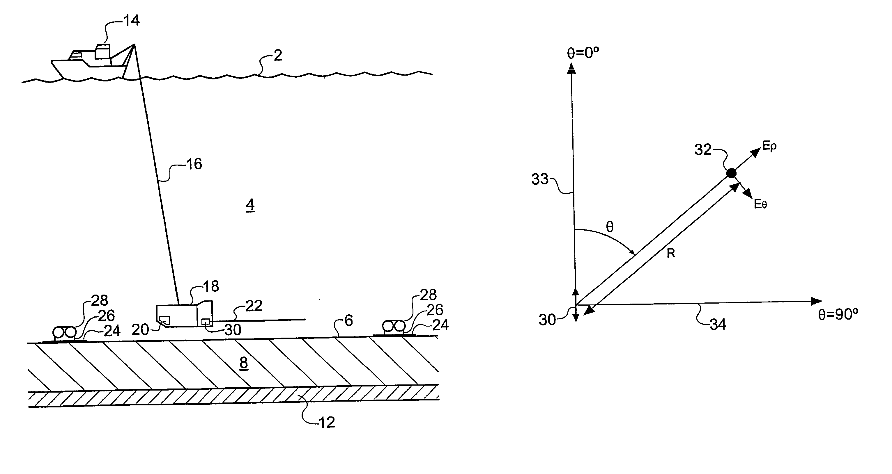
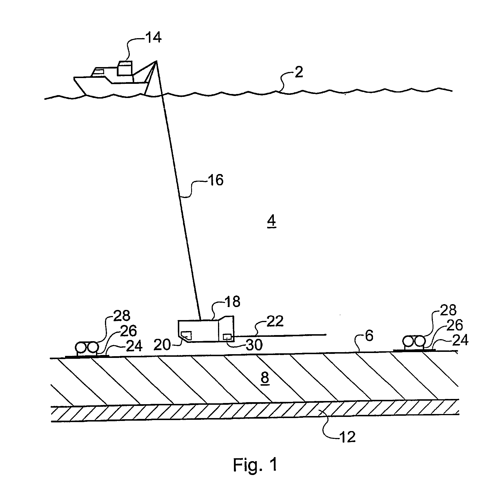
[0051]FIG. 1 of the accompanying drawing shows schematically a surface vessel 14 undertaking EM sounding of subterranean rock strata 8 within which a hydrocarbon reservoir 12 is located. The surface vessel 14 floats on the surface 2 of the sea 4. A deep-towed vehicle 18 is attached to the surface vessel 14 by an umbilical cable 16 which provides an electrical, optical and mechanical connection between the deep-towed vehicle 18 and the surface vessel 14. The deep-towed vehicle 18 is towed by the surface vessel 14 such that it remains consistently close to the seafloor 6. This is facilitated by an echo-location package 20 which relays information about the height of the deep-towed vehicle 18 above the seafloor 6 to the surface vessel 14. The deep-towed vehicle 18 receives electrical power from the ship's on-board power supply via the umbilical cable 16.

[0052]A cycloconverter unit 30 generates the chosen waveform to be supplied to an EM source in the form of a transmitting antenna 22 w...


PUM


Abstract

An electromagnetic survey method for surveying an area previously identified as potentially containing a subsea hydrocarbon reservoir, comprising obtaining first and second survey data sets with an electromagnetic source aligned end-on and broadside relative to the same or different receivers. The invention also relates to planning a survey using this method, and to analysis of survey data taken in combination allow the galvanic contribution to the signals collected at the receiver to be contrasted with the inductive effects, and the effects of signal attenuation, which are highly dependent on local properties of the rock formation, overlying water and air at the survey area. This is very important to the success of using electromagnetic surveying for identifying hydrocarbon reserves and distinguishing them from other classes of structure.

Description

[0001]This application is a national phase of International Application No. PCT / GB02 / 05355 filed Nov. 28, 2002 and published in the English language.BACKGROUND OF THE INVENTION[0002]The invention relates to seafloor electromagnetic surveying for oil and other hydrocarbon reserves.[0003]Determining the response of the sub-surface strata within the earth's crust to electromagnetic fields is a valuable tool in the field of geophysical research. The geological processes occurring in thermally, hydrothermally or magmatically active regions can be studied. In addition, electromagnetic sounding techniques can provide valuable insights into the nature, and particularly the likely hydrocarbon content, of subterranean reservoirs in the context of subterranean oil exploration and surveying.[0004]Seismic techniques are often used during oil-exploration expeditions to identify the existence, location and extent of reservoirs in subterranean rock strata. Whilst seismic surveying is able to identi...

Claims


Application Information

Patent Timeline
Patent Type & Authority Patents(United States)
IPC IPC(8): G01V3/08G01V3/12
CPCG01V3/083G01V3/12Y02A90/30
Inventor MACGREGOR, LUCY MSINHA, MARTIN C
Owner STATOIL ASA PETRO SA (NO)
Why Eureka
Try Eureka