Method and apparatus for enhancing a digital elevation model (DEM) for topographical modeling

a topographical modeling and digital elevation technology, applied in the field of topography, can solve the problems that the dems are generally not well suited to modeling man-made structures, and achieve the effect of reducing nois

Inactive Publication Date: 2006-11-28
HARRIS CORP
View PDF6 Cites 111 Cited by
  • Summary
  • Abstract
  • Description
  • Claims
  • Application Information

AI Technical Summary

Benefits of technology

[0007]This and other objects, features, and advantages in accordance with the present invention are provided by a computer implemented method for processing an original digital elevation model (DEM) including data for terrain and a plurality of objects thereon. The method may comprise generating a lower-resolution DEM from the original DEM, generating an objects-only DEM based upon a comparison of the lower-resolution DEM and the original DEM, and reducing noise in the objects-only DEM.
[0010]A noise-only DEM may be generated based upon a comparison between the first refined objects-only DEM and the second refined objects-only DEM. The noise-only DEM may be subtracted from the second refined objects-only DEM for generating a final refined objects-only. The final refined objects-only DEM may have significantly less noise than the initial objects-only DEM that is typically used in the prior art for topographical modeling. This advantageously results in a more realistic topographical modeling.
[0012]A lower-resolution DEM without the objects is generated from the original DEM without the objects, and nulls in the lower-resolution DEM without the objects are identified based upon the first window size, and the nulls are filled in for generating a terrain-only DEM. A refined objects-only DEM may then be generated based upon a comparison of the terrain-only DEM with the original DEM. The refined objects-only DEM may have significantly less noise than the initial objects-only DEM that is typically used in the prior art for topographical modeling. Again, this advantageously results in a more realistic topographical modeling.
[0014]Another aspect in accordance with the present invention is directed to a computer-readable medium having stored thereon a data structure for processing a digital elevation model (DEM) including data for terrain and a plurality of objects thereon. A first embodiment of the computer-readable medium may comprise a first data field containing data for generating a lower-resolution DEM from the original DEM, a second data field containing data for generating an objects-only DEM based upon a comparison of the lower-resolution DEM and the original DEM, and a third data field containing data for reducing noise in the objects-only DEM.

Problems solved by technology

For this reason, DEMs generally are not well suited for modeling man-made structures, such as skyscrapers in a downtown area, with sufficient accuracy for many of the above applications.
In addition, the quality of the DEMs affect modeling of the terrain, and modeling of the buildings and foliage on the terrain.

Method used


Image

  • Method and apparatus for enhancing a digital elevation model (DEM) for topographical modeling
  • Method and apparatus for enhancing a digital elevation model (DEM) for topographical modeling
  • Method and apparatus for enhancing a digital elevation model (DEM) for topographical modeling

Examples


Embodiment Construction

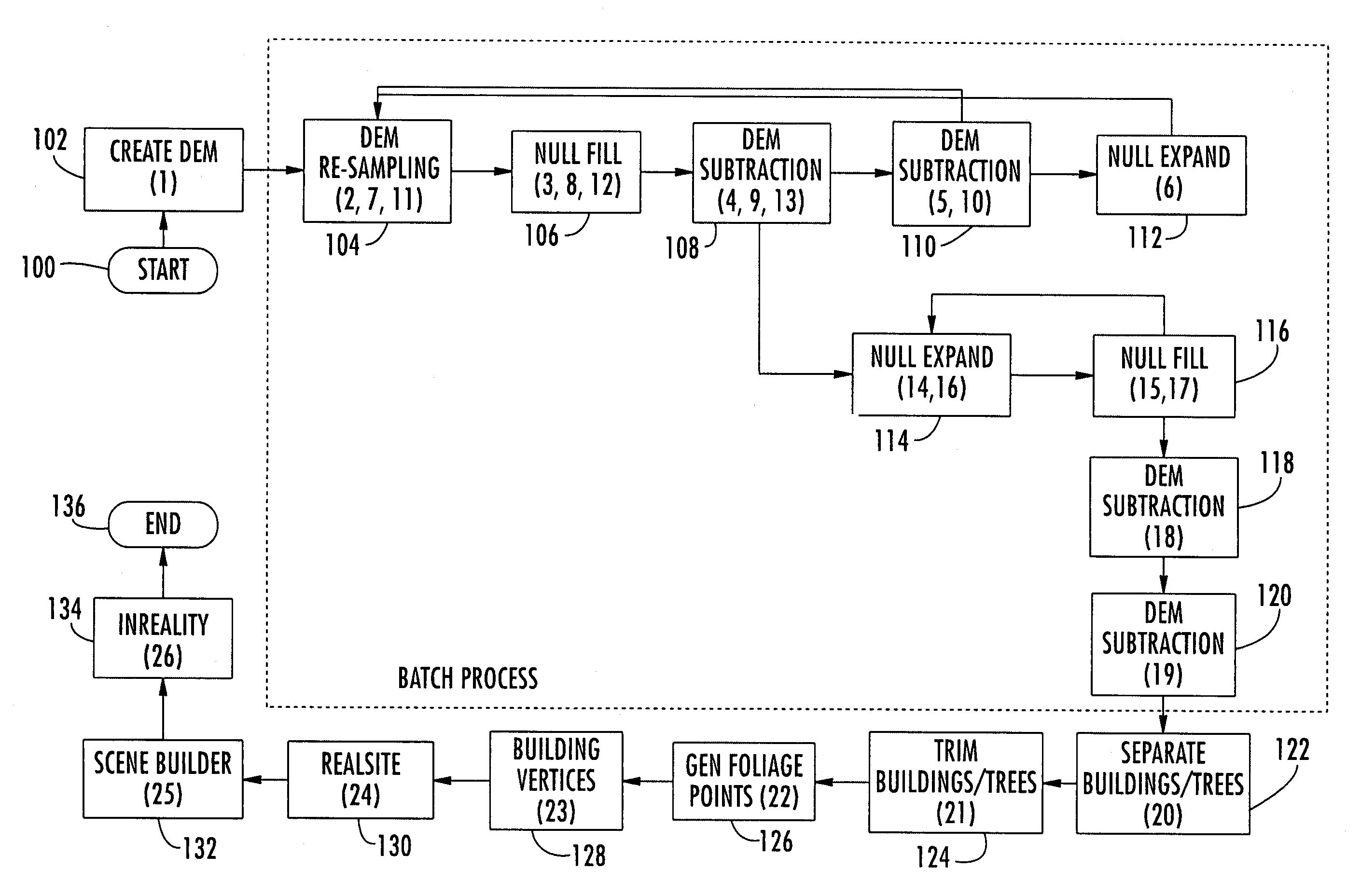
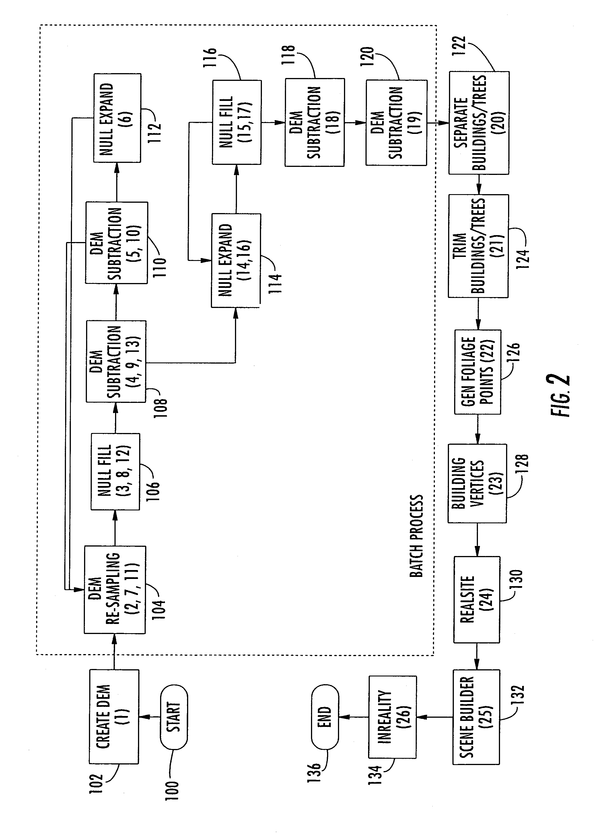
[0034]The present invention will now be described more fully hereinafter with reference to the accompanying drawings, in which preferred embodiments of the invention are shown. This invention may, however, be embodied in many different forms and should not be construed as limited to the embodiments set forth herein. Rather, these embodiments are provided so that this disclosure will be thorough and complete, and will fully convey the scope of the invention to those skilled in the art. Like numbers refer to like elements throughout.

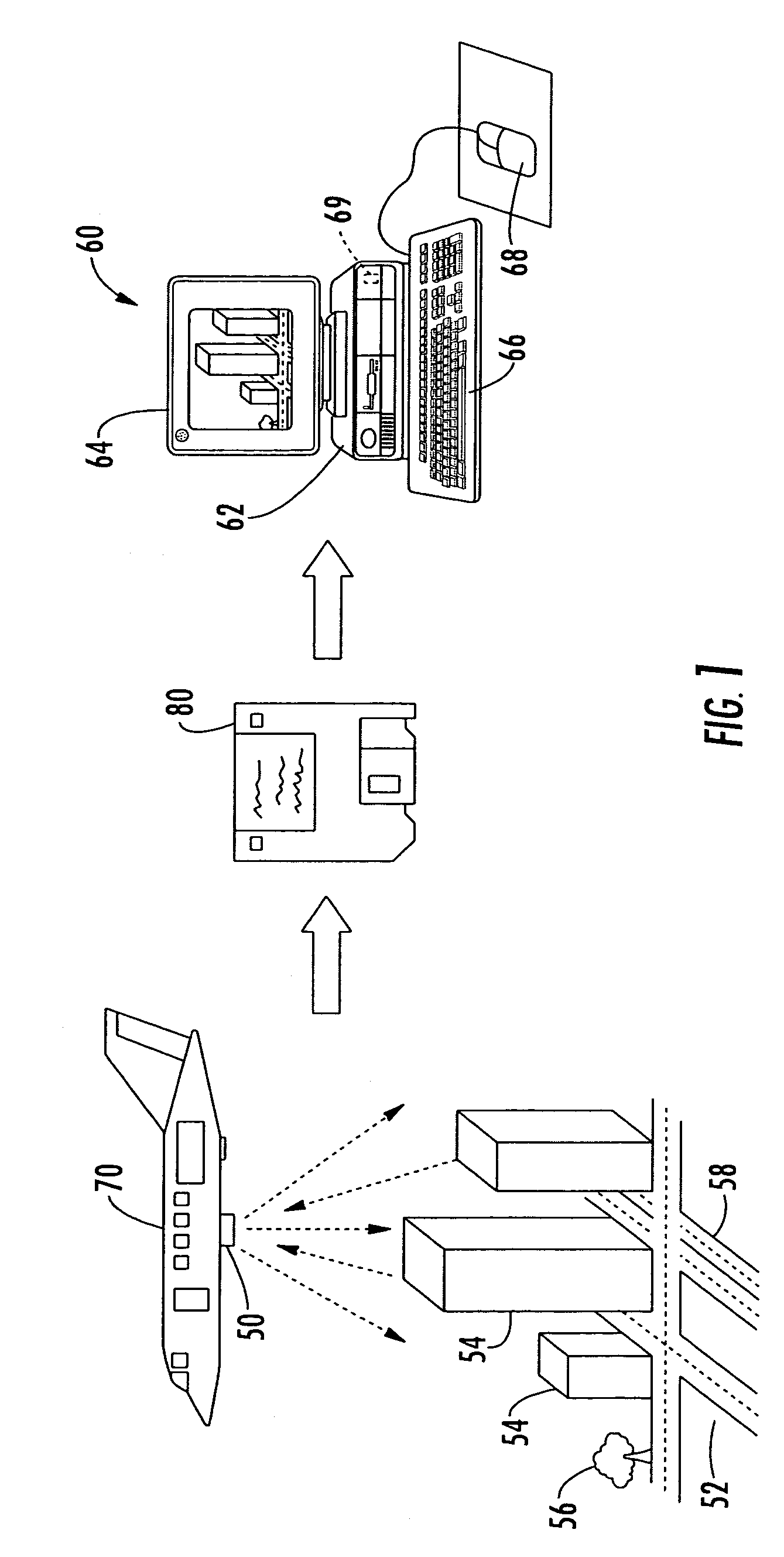
[0035]A collector 50 for collecting topographical data and a system 60 for generating a digital elevation model (DEM) from the collected topographical data will now be explained with reference to FIG. 1. The DEM is of an area that includes terrain 52 and objects on the terrain, wherein the objects may be buildings 54 and foliage 56. The foliage 56 primarily includes trees, and consequently, foliage and trees will be interchangeable. Modeling of the terrain...


PUM


Abstract

A computer implemented method is for processing an original digital elevation model (DEM) including data for terrain and a plurality of objects thereon. The method includes generating a lower-resolution DEM from the original DEM, and generating an objects-only DEM based upon a comparison of the lower-resolution DEM and the original DEM. The method further includes reducing noise in the objects-only DEM.

Description

FIELD OF THE INVENTION [0001]The present invention relates to the field of topography, and more particularly, to a method for enhancing a digital elevation model (DEM) before modeling the buildings, foliage and terrain within the DEM.BACKGROUND OF THE INVENTION [0002]Topographical models of geographical areas may be used for many applications, including flight simulators and flood plain analysis. Furthermore, topographical models of man-made structures (e.g., cities) may be extremely helpful in applications such as cellular antenna placement, urban planning, disaster preparedness and analysis, and mapping, for example.[0003]Various types and methods for making topographical models are presently being used. One common topographical model is the digital elevation model (DEM). A DEM is a sampled matrix representation of a geographical area which may be generated in an automated fashion by a computer. In a DEM, coordinate points are made to correspond with a height value. DEMs are typic...

Claims


Application Information

Patent Timeline
Patent Type & Authority Patents(United States)
IPC IPC(8): G06F19/00G06T17/05G06V10/30
CPCG01C11/00G01S17/89G06K9/40G06T17/05G06V10/30
Inventor RAHMES, MARKKARP, JOHNSMITH, ANTHONYCONNETTI, JR., STEPHEN
Owner HARRIS CORP
Why Eureka
Try Eureka