Barometric floor level indicator

a barometer and floor technology, applied in the direction of navigation instruments, process and machine control, instruments, etc., can solve the problems of inability to use a conventional navigation device to determine, and the navigation device may not be able to determine its position

Inactive Publication Date: 2007-01-09
HONEYWELL INT INC
View PDF11 Cites 168 Cited by
  • Summary
  • Abstract
  • Description
  • Claims
  • Application Information

AI Technical Summary

Problems solved by technology

In such operating conditions, the navigation device may not be able to determine its position.
For example, a fireman entering a burning building may need to know what floor he / she is on but because of interference, may be unable to use a conventional navigation device to determine the current floor.

Method used


Image

  • Barometric floor level indicator
  • Barometric floor level indicator
  • Barometric floor level indicator

Examples


Embodiment Construction

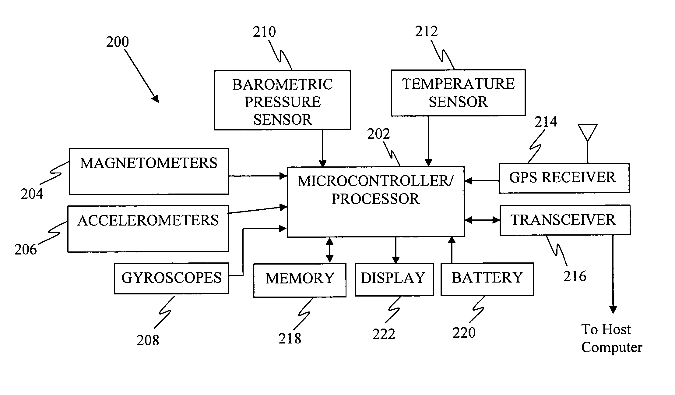
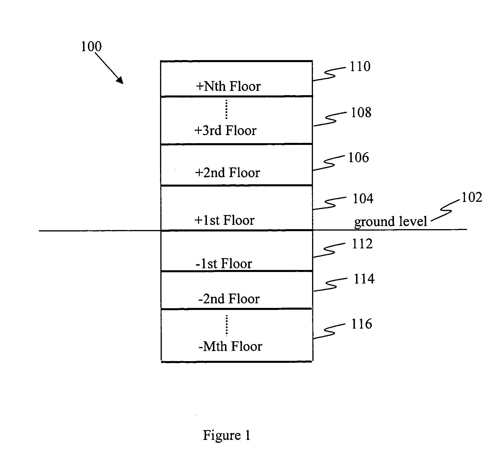
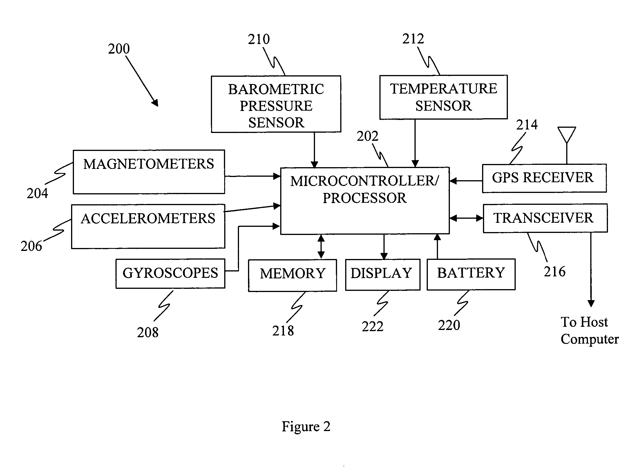
[0012]Methods and systems that implement the embodiments of the various features of the invention will now be described with reference to the drawings. The drawings and the associated descriptions are provided to illustrate embodiments of the invention and not to limit the scope of the invention. Reference in the specification to “one embodiment” or “an embodiment” is intended to indicate that a particular feature, structure, or characteristic described in connection with the embodiment is included in at least an embodiment of the invention. The appearances of the phrase “in one embodiment” or “an embodiment” in various places in the specification are not necessarily all referring to the same embodiment. Throughout the drawings, reference numbers are re-used to indicate correspondence between referenced elements. In addition, the first digit of each reference number indicates the figure in which the element first appears.

[0013]In the following description, certain terminology is use...


PUM


Abstract

The invention relates to a device, system, and method for providing a multi-mode navigation device. In a first mode of operation, the navigation device provides position information based on a radio frequency navigation signals. If radio signals become unavailable, the navigation device enters a second mode of operation. In the second mode of operation the navigation device stores the most recent elevation and associates it with a reference elevation, the reference elevation is associated with an entry floor. The difference between a current elevation and the reference elevation is determined and this difference is divided by a floor height to obtain a floor number. The navigation device provides the floor number while reliable global position information is unavailable.

Description

FIELD OF THE INVENTION[0001]Various embodiments of the invention pertain to navigation devices. At least one embodiment of the invention pertains to a mobile navigation device that indicates to a user the current floor of a building as the user navigates the building.DESCRIPTION OF RELATED ART[0002]Radio frequency-based navigation devices have been used to track the position of a person or vehicle and / or inform a person or vehicle of their current location. In many instances, such navigation devices include global positioning systems (GPS), global navigation satellite systems (GNSS), compasses, inertial and other radio frequency (RF) navigation technologies.[0003]In various applications, it may be desirable to employ a navigation device in an urban area or inside buildings where GPS is sometimes unreliable. In such operating conditions, the navigation device may not be able to determine its position.[0004]In some implementations, it is helpful to obtain the relative and / or absolute ...

Claims


Application Information

Patent Timeline
Patent Type & Authority Patents(United States)
IPC IPC(8): G01C21/28
CPCG01C21/28G01C5/06
Inventor LEVI, ROBERT W.VU, TOAN X.
Owner HONEYWELL INT INC
Why Eureka
Try Eureka