

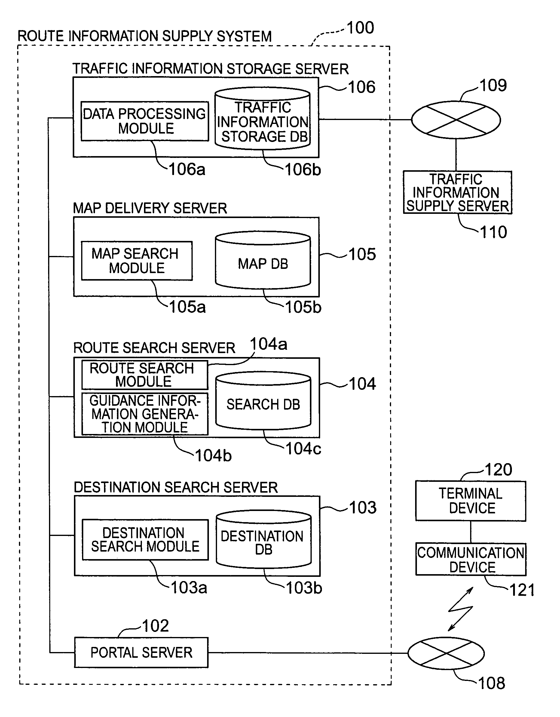
Method and apparatus for communicating map and route guidance information for vehicle navigation
a technology for vehicle navigation and route guidance, applied in the field of route information supply system, can solve the problems of information not being used, the display scale after adjustment might not suit the user's intention, and the efficiency of memory usage, so as to achieve efficient reduction of map data and maintain the effect of map visibility
- Summary
- Abstract
- Description
- Claims
- Application Information
AI Technical Summary
Benefits of technology
Problems solved by technology
Method used
Image

Examples
first embodiment
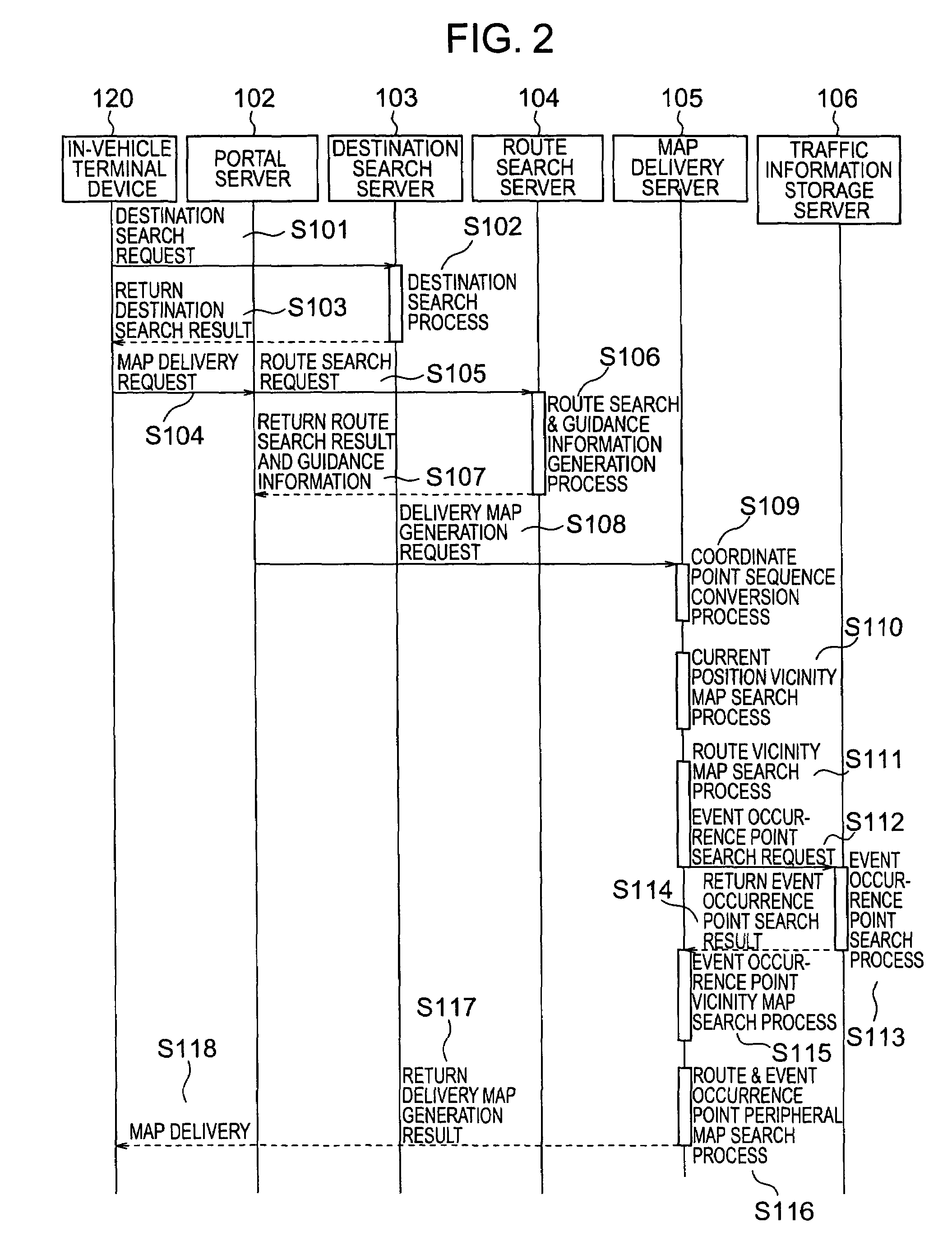
[0064]In the following, the operation of the communicating navigation system of the present invention will be described referring to a sequence chart of FIG. 2. In this embodiment, the display mode of the map information supplied from the route information supply system 100 in the route search is changed based on the traffic information obtained from the traffic information supply server 110.
[0065]First, the terminal device 120 transmits a destination search request to the destination search server 103 via the portal server 102 (S101). The destination search request contains search conditions such as an address and a type of facility which have been inputted by the user.
[0066]The destination search module 103a of the destination search server 103 searches the destination DB 103b and thereby extracts a record satisfying the search conditions (S102). After the search, the destination search module 103a transmits the name, address, positional information (latitude, longitude, etc.), et...
second embodiment
[0098]In the following, the operation of a communicating navigation system in accordance with the present invention will be described referring to a sequence chart of FIG. 6. In this embodiment, the traffic information is taken into consideration in the route search and detailed maps are displayed also for areas around a detour route.
[0099]In FIG. 6, steps S201-S207 are identical with the steps S101-S107 of the first embodiment. Incidentally, the route obtained in the step S206 will be referred to as a “main route” so that it can be distinguished from a detour which will be explained later.
[0100]The portal server 102 which received the route search result and the guidance information transmits an event occurrence point search request to the traffic information storage server 106 (S208). The event occurrence point search request is identical with that in the first embodiment (S112).
[0101]An event occurrence point search process (S209) and an event occurrence point search result retur...
fourth embodiment
[0127]In the following, the operation of a communicating navigation system in accordance with the present invention will be described referring to a sequence chart of FIG. 10.
[0128]In FIG. 10, steps S401-S410 are the same as the steps S201-S210 of the second embodiment. Steps S411-S414 are the same as the steps S214-S217 of the second embodiment.
[0129]Subsequently, peripheral maps for the main route considering no traffic information are searched for (S415) and map information obtained by the above steps is delivered to the terminal device 120 (S416, S417).
[0130]Thereafter, when a detour search request is transmitted by the terminal device 120 to the portal server 102 (S418), the portal server 102 sends the detour search request to the route search server 104 (S419).
[0131]The route search server 104 carries out a detour search & guidance information generation process (S420) and returns detour information and a guidance information result to the portal server 102 (S421).
[0132]The po...
PUM
 Abstract
Description
Claims
Application Information