Method of recognizing an object in an image using multi-sensor integration through conditionally optimal geoscene generation and registration

a multi-sensor image and object technology, applied in scene recognition, instruments, computing, etc., can solve the problems of image users not considering the reality of the shape of the pixels of the ikonos imagery, information extraction from multi-sensor images is usually a more difficult procedure, and the world over remote sensing researchers have assumed these satellite images have square pixels

Active Publication Date: 2008-03-11
HSU SHIN YI
View PDF6 Cites 21 Cited by
  • Summary
  • Abstract
  • Description
  • Claims
  • Application Information

AI Technical Summary

Benefits of technology

[0044]A virtual transverse Mercator (VTM) projection is defined to help process image

Problems solved by technology

Information extraction from multi-sensor images is usually a more difficult procedure than is information extraction from a single sensor image simply because multi-sensor images are almost never spatially registered.
Since IKONOS, SPOT and LANDSAT images are much more popular than are DOQ and CIB-5 images, it is unthinkable that most remote sensing researchers the world over have assumed these satellite images have square pixels.
For the most part, image users have not considered the reality of the shape of the pixels of the IKONOS imagery.
The existence of non-square pixels among dissimilar imagery types, however, is one of the critical reasons why mismatching exists among multi-sensor images.
Spatial mismatch among multispectral images may result from dissimilarities in their resolution levels, their location or translation, their depression angles, their orientations, and combinations of these factors.
The problem of using ortho-rectification as a means of image registration stems from the fact that ortho-rectification by itself is a very complex process.
Consequently, in many cases, it cannot be assumed that ortho-rectified imagery is a natural product of any particular sensing system.
While computational procedures for image registration are computerized, the steps that the image analyst must follow are usually both time-consuming and tedious.
Another drawback

Method used


Image

  • Method of recognizing an object in an image using multi-sensor integration through conditionally optimal geoscene generation and registration
  • Method of recognizing an object in an image using multi-sensor integration through conditionally optimal geoscene generation and registration
  • Method of recognizing an object in an image using multi-sensor integration through conditionally optimal geoscene generation and registration

Examples


Embodiment Construction

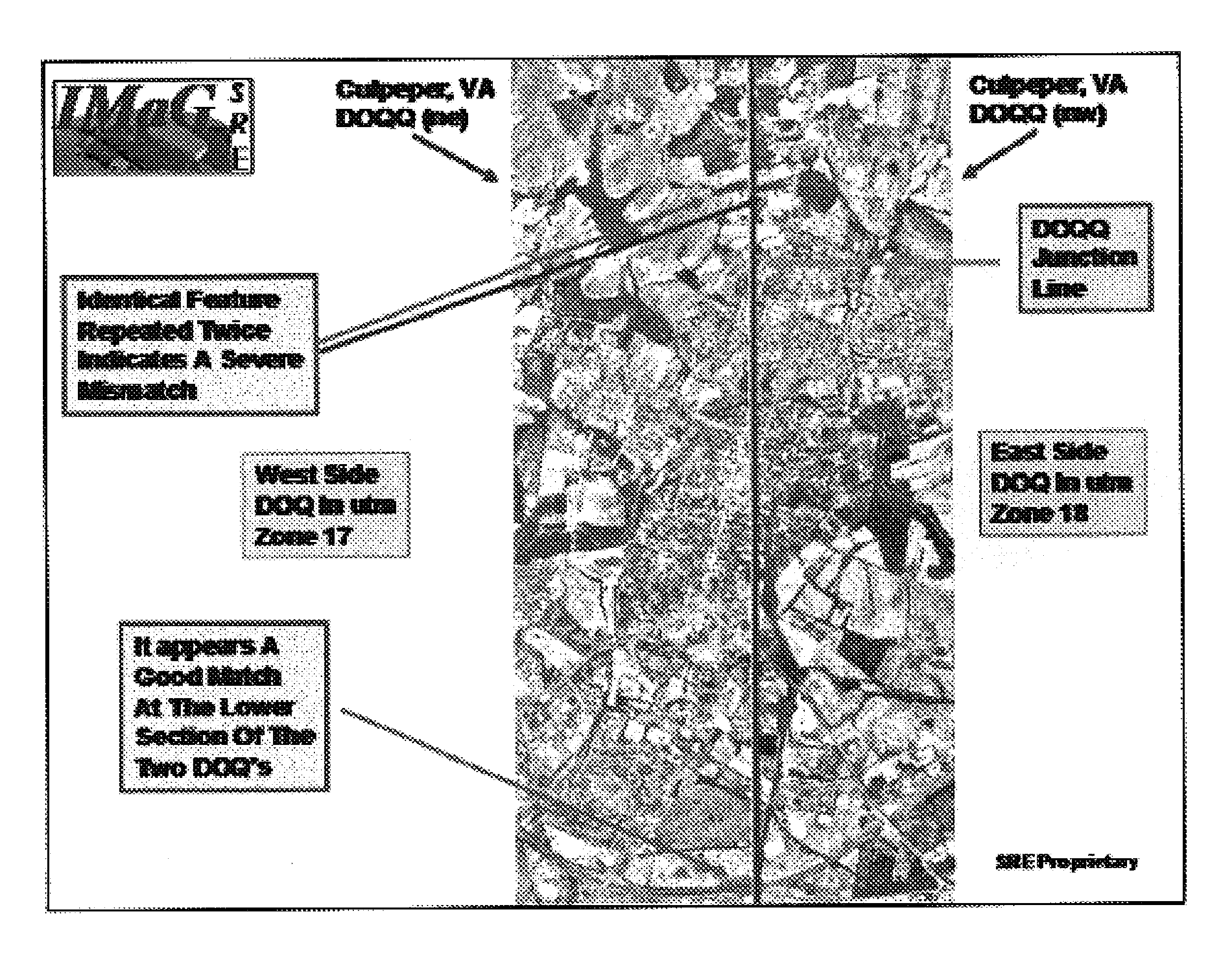
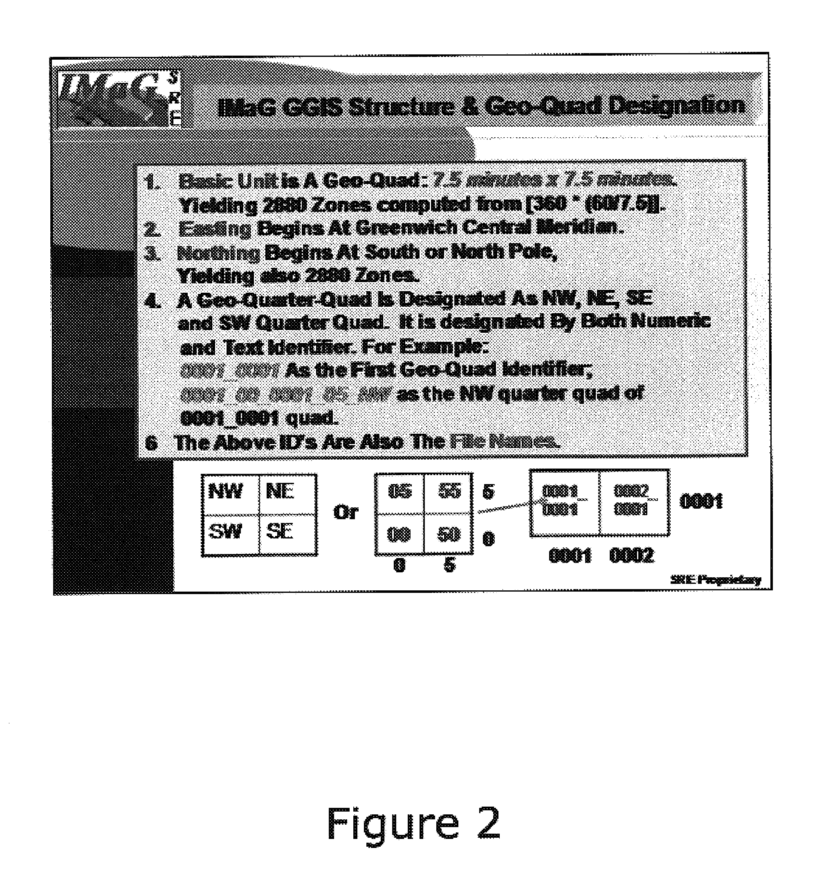
[0060]The method of the present invention begins with generating geoscenes using four different models. A geoscene is defined in terms of an image in which every pixel is denoted by four locational identification systems:[0061]a) (x,y) coordinates in the image domain;[0062]b) UTM or VTM coordinates in the map projection domain;[0063]c) decimal degree in the geospatial domain; and[0064]d) degrees, minutes and seconds in the geospatial domain.

[0065]Several tools exist to perform conversions between or among various coordinate systems. First, a bi-directional method for conversion between lat-long and UTM is required. Basic methods for two-way lat-long to UTM conversions are provided in Wolf and Ghilani in Elementary Surveying: An Introduction to Geomatics (New York: Prentice Hall, 2002). However, a superior method of performing such conversions is provided by the present invention.

[0066]In the UTM system, the geographic location of each zone is fixed. Consequently, the central meridia...


PUM


Abstract

A method of recognizing an object in an image using multi-sensor integration through conditionally optimal geoscene generation and registration is provided. At least two images, one of which is a conditionally optimum, ortho-rectified base image, are input and used to generate a geoscene using at least two ground control points in a latitude-longitude geospatial domain. Georegistration of the geoscene produces a registered geoimage which may be output. A virtual geospatial information system database may be compiled from the georegistered images. A virtual transverse Mercator (VTM) projection is defined which allows processing images falling on both sides of the equator or across traditional UTM boundaries. An Affine transform is used for coordinate transformation in generating geoscenes. The georegistration process utilizes the union and the intersection of image pixels, and geolayering with interacting layers including geogrids and text layers, to define main body and background pixels to facilitate object recognition.

Description

RELATED APPLICATIONS[0001]The present invention is related to copending U.S. patent application Ser. Nos. 10 / 412,954 filed Apr. 15, 2003, and Ser. No. 10 / 623,089 filed Jul. 18, 2003, and to U.S. patent application Ser. No. 08 / 066,691, filed May 21, 1993, now issued as U.S. Pat. No. 5,631,970, all of which are included herein in their entirety by reference.FIELD OF THE INVENTION[0002]The present invention relates to object recognition in an image and, more particularly to recognition of an object in an image by generating, registering, and measuring geoscenes to integrate multi-sensor images.BACKGROUND OF THE INVENTION[0003]In pattern recognition and remote sensing, object recognition is typically performed by gradually accumulating evidences from various sensors and components within individual sensors. The first approach is usually referred to as intra-sensor integration, whereas the latter is referred to as inter-sensor integration. Information extraction from multi-sensor images ...

Claims


Application Information

Patent Timeline
IPC IPC(8): G06K9/32G06K9/36G06V20/13
CPCG06K9/0063G06V20/13
Inventor HSU, SHIN-YI
Owner HSU SHIN YI
Why Eureka
Try Eureka