
Methods and apparatus for a navigation system with reduced susceptibility to interference and jamming

a navigation system and susceptibility technology, applied in the field of navigation systems, can solve the problems of sensitivity tending to work against the practicality of satellite navigation, full reliance, and risk of large-scale disruption of air traffic, and achieve the effects of improving jamming, cost, weight, and power

Active Publication Date: 2008-05-13
THE BOEING CO
View PDF15 Cites 105 Cited by
  • Summary
  • Abstract
  • Description
  • Claims
  • Application Information

AI Technical Summary

Benefits of technology

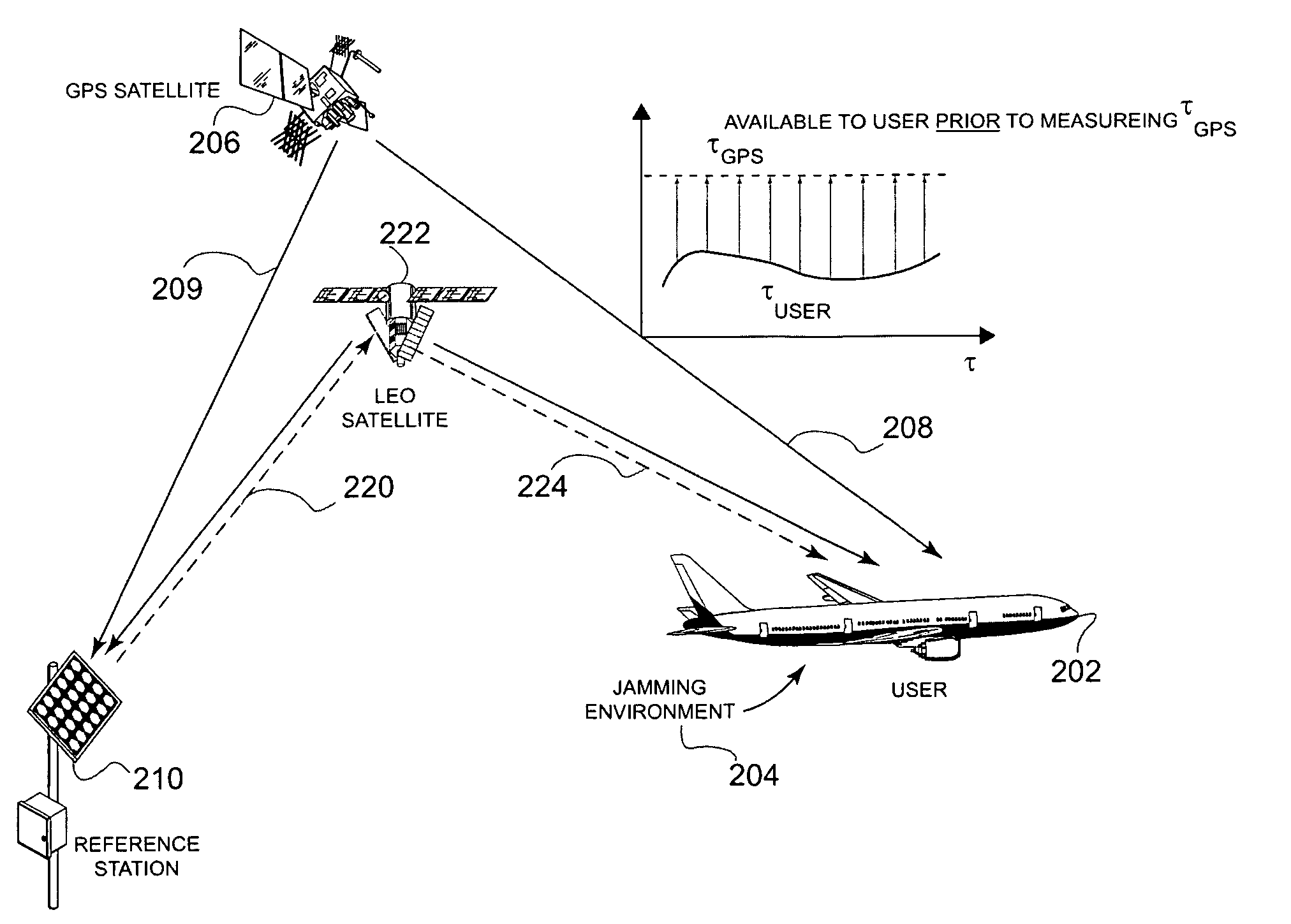
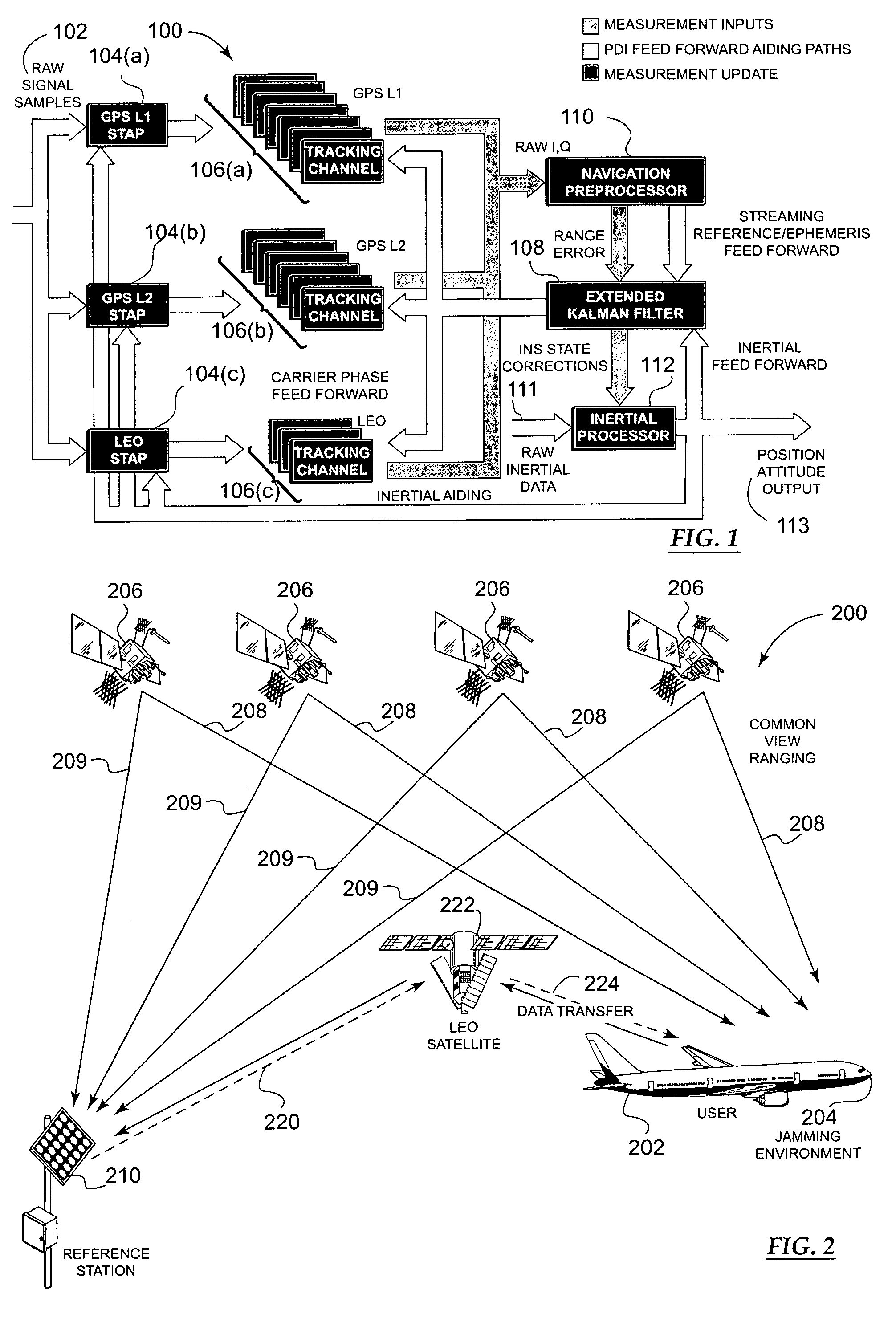
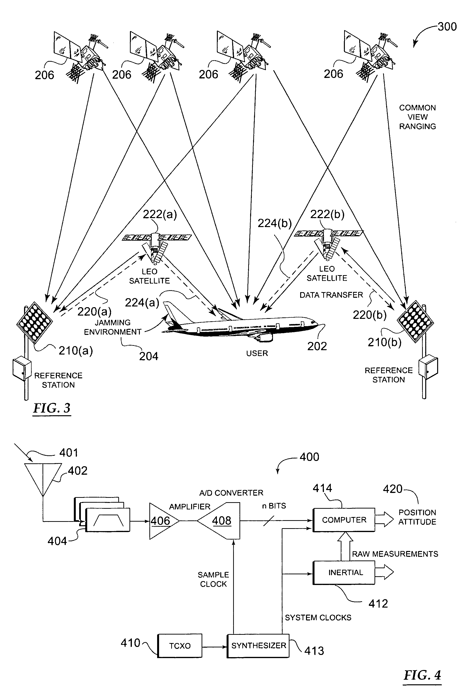
[0021]Systems and methods in accordance with the present invention generally employ a network of ground reference stations and Low Earth Orbiting (LEO) satellites in conjunction with one or more GPS satellites. A first common-view ranging geometry to a GPS satellite is established to link a reference station and a user. A second common-view geometry to a LEO satellite between the same reference station and user is also established. The ground stations synthesize real-time aiding signals by making carrier phase measurements of the GPS and LEO satellite signals. This aiding information is transmitted via the LEO satellites to the user receiver at high power to penetrate ambient jamming. The user receiver locks onto the carrier phase of the LEO satellite, demodulates the aiding information, then applies the carrier phase measurements and the aiding information to enable extended coherent measurements of the GPS signals. The system thereby recovers the GPS signals that would otherwise be lost to the jamming. In this way, the present invention provides significant improvements in jam-immunity at a cost, size, weight, and power comparable to that of an ordinary GPS receiver.

Problems solved by technology

Unfortunately, the presence of jamming and / or interference has prevented full reliance on GPS as means of navigation, especially in certain military or safety-of-life applications.
However, a dependence on GPS as currently structured could result in a risk of large-scale disruption to air traffic and, therefore, commerce in general.
Furthermore, the increasing extent to which GPS is embedded in day-to-day infrastructure, such as ground and marine transportation, and the timing of electrical power distribution, the Internet, cellular telephones, and financial transactions, serves to increase potential societal vulnerabilities due to intentional disruption of the GPS signal from jamming.
Such sensitivity tends to work against the practicality of satellite navigation and, conversely, in favor of traditional higher-power navigation aids used for aviation, some of which predate GPS, including VOR, DME, ILS, TACAN, and LORAN-C.
Currently, aircraft can only use GPS for supplemental-means navigation.
Therefore, because of the signal vulnerability of GPS, there is little incentive to take advantage of the significant performance and cost advantages of satellite navigation.
However, there is a price for raw power: each Watt of extra power scales up the satellite payload and launch costs accordingly, such that significant increases in broadcast power quickly become expensive.
Here, too, there is a price to pay: efficient use of finite spectrum for multiple purposes requires significant global coordination.
CRPAs can be quite effective in most circumstances, although they are generally expensive and bulky.
They also have a drawback of becoming less effective when a jammer line-of-sight happens to be nearly coincident with a satellite or, worse yet, when several distributed jammers are used.
However, it is insufficient in and of itself to eliminate all the effects of interference or jamming.
For example, if a jammer is broadband noise, the receiver would detect the presence of jamming, but would be unable to apply excision to selectively remove any part of it without a priori knowledge of its character.
Attempts to improve upon this level of protection have traditionally encountered several barriers to practical implementation.
Unfortunately, for military or safety-of-life applications, the method cannot always be counted on because the pre-recorded data message does not always track the actual broadcast message.
Consistency between the two data streams can be thrown off by any number of factors, including new ephemeris uploads, operational errors, and system failures.
Unfortunately, regardless of whether data is removed from the GPS carrier, significant obstacles remain in attempting to narrow the pre-detection bandwidth or making use of low signal level measurements.
Unfortunately, ultra-tightly-coupled inertials have only been effective to a certain level of protection.
The physics of such systems quickly limits their ability to withstand significant jamming.
First, due to squaring losses stemming from the discriminator, long integration times are required.
Second, inertial instruments exhibit errors that grow with time.
Although some inertial instruments can provide better performance at increased cost, there are practical physical limits as to how long an inertial can remove the platform dynamics without an update from GPS.
This limit is usually set by the time the inertial noise takes to reach a large fraction of a code chip—usually about 5 m. For a given quality of inertial, the dependence on GPS code modulation yields a certain jamming level at which the ranging error exceeds a threshold during integration and the system is no longer useful.
Such an approach has traditionally been seen as impractical because the receiver must integrate the carrier over a sustained interval to a stability of less than 30 picoseconds (the amount of time it takes light to traverse 1 cm).
The challenge is to maintain this required stability over an interval that is much longer than 20 ms.
Beyond this, a TCXO is not sufficiently stable.
Other more stable exotic clocks such as ovenized quartz or atomic clocks based on rubidium or cesium frequency standards are candidates, but even these highly stable clocks have practical issues that do not render them practical.
At this level, even many atomic clocks are not capable of providing the needed stability.
Vibration, bulk, and cost can become prohibitive.
A promising new Chip Scale Atomic Clock (CSOC) approach offers potential to reduce cost, size, weight, and power some years from now, but even the most optimistic projections of performance do not achieve sufficient frequency stability to yield the required phase stability over the needed interval.
However, an OCXO is typically bulky, expensive, and power consuming.
A solution depending on such highly stable clocks is not readily accessible without the cost, size, weight, and power consumption associated with precise temperature control.
Such a solution with high premium on component performance sensitivity is a significant technical challenge.
Power, vibration, and cost become major obstacles.
Unfortunately, even relatively low-power jammers are capable of bringing down user equipment within line of sight of the jammer.
However, even if the cost of deploying such a high-power system were not an object, it will still be many years before such a system will be available for use.
However, these solutions may also fall short under future jamming scenarios—especially as mentioned previously with respect to large numbers of low-power, distributed jammers.
Perhaps most important, the set of current solutions described above all tend to be expensive.
Civil vulnerability is a significant challenge.
Because only one frequency is required for many operations, if one frequency is down due to unintentional interference, the other stands a high probability of being operational.
The problem of intentional jamming is much worse.
Installing expensive user equipment adapted from the Military, such as CRPA antennas, to the civil aircraft fleet has been viewed negatively.
Because satellite solutions such as the WAAS do not provide any additional value to aviation users because the existing ground aids are also in operation, there is little incentive for the airlines to transition onto satellite navigation.
In addition to the growing dependence on GPS for a variety of commercial functions in society, including timing of the Internet, the power grid, cellular telephone networks, and financial transaction timing, there is also a potential regulatory threat to GPS signal strength that could originate from Ultra-Wide Band (UWB) technology.
While UWB has significant promise, there is a distinct possibility of interference if the GPS band is not carefully protected from a regulatory standpoint.
In summary, existing systems and methods for providing jam-immunity are unsatisfactory.

Method used


Image

  • Methods and apparatus for a navigation system with reduced susceptibility to interference and jamming
  • Methods and apparatus for a navigation system with reduced susceptibility to interference and jamming
  • Methods and apparatus for a navigation system with reduced susceptibility to interference and jamming

Examples


Embodiment Construction

[0042]The following detailed description is merely illustrative in nature and is not intended to limit the invention or the application and uses of the invention. Furthermore, there is no intention to be bound by any expressed or implied theory presented in the preceding technical field, background, brief summary or the following detailed description.

[0043]The invention may be described herein in terms of functional and / or logical block components and various processing steps. It should be appreciated that such block components may be realized by any number of hardware, software, and / or firmware components configured to perform the specified functions. For example, an embodiment of the invention may employ various integrated circuit components, e.g., memory elements, antennas, digital signal processing elements, logic elements, look-up tables, or the like, which may carry out a variety of functions under the control of one or more microprocessors or other control devices. In additio...


PUM


Abstract

A navigation system provides a significant level of protection against all forms of interference or jamming to GPS in a cost-effective way. The system employs a network of ground reference stations and Low Earth Orbiting (LEO) satellites in conjunction with GPS. A common-view ranging geometry to a GPS satellite is established that links a reference station and a user. A second common-view geometry to a LEO satellite between the same reference station and user pair is also established. The ground stations synthesize real-time aiding signals by making carrier phase measurements of GPS the LEO satellite signals. This aiding information is transmitted via the LEO satellites to the user receiver at high power to penetrate ambient jamming. The user receiver locks onto the carrier phase of the LEO satellite, demodulates the aiding information, then applies the carrier phase measurements and the aiding information to enable extended coherent measurements of the GPS signals. The system thereby recovers the GPS signals that would otherwise be lost to the jamming.

Description

TECHNICAL FIELD[0001]The present invention generally relates to navigation systems and, more particularly, to satellite navigation systems operating in environments prone to jamming and interference.BACKGROUND[0002]In recent years, users of global positioning systems (GPS) have enjoyed real-time three-dimensional navigation capabilities at previously-unavailable performance levels. Except for their susceptibility to interference and jamming, such GPS systems have largely fulfilled the promise of accurate, worldwide satellite navigation. Nevertheless, users continue to demand increasingly high navigation performance, particularly with respect to accuracy and integrity—i.e., the ability of a navigation system to detect false navigation information.[0003]Unfortunately, the presence of jamming and / or interference has prevented full reliance on GPS as means of navigation, especially in certain military or safety-of-life applications. In civil aviation, safety risk due to jamming is gener...

Claims


Application Information

Patent Timeline
Patent Type & Authority Patents(United States)
IPC IPC(8): G01S1/00G01S19/05G01S5/14G01S19/11G01S19/21G01S19/29G01S19/43G01S19/46
CPCG01S19/05G01S19/11G01S19/21H04K3/90G01S19/43G01S19/46H04K3/255G01S19/29
Inventor COHEN, CLARK E.BRUMLEY, ROBERT W.PSIAKI, MARK L.GUTT, GREGORY M.BENCZE, WILLIAM J.LEDVINA, BRENT M.FERRELL, BARTON G.WHELAN, DAVID A.
Owner THE BOEING CO
Learn More