

Method and device for personal location based on motion measurement information
A positioning method and motion technology, applied in the field of navigation and positioning, can solve the problems of low accuracy, poor reliability and environmental adaptability, and achieve the effects of high reliability and accuracy, high positioning accuracy, and strong anti-interference.
- Summary
- Abstract
- Description
- Claims
- Application Information
AI Technical Summary
Problems solved by technology
Method used
Image


Examples
Embodiment 1
[0095] A personal positioning method based on motion measurement information, comprising the following steps:
[0096] 1) Calibrate motion model parameters
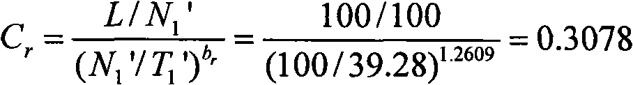
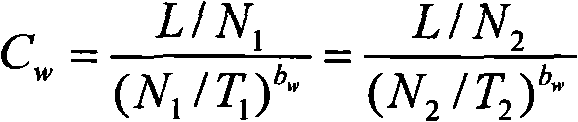
[0097] In this example, L=100m, N 1 =196,T 1 =158.05s,N 2 =138,T 2 =60.98s, so:
[0098] b w = lg ( N 2 / N 1 ) lg ( N 1 T 2 / N 2 T 1 ) = lg ( 138 / 196 ) ...
Embodiment 2
[0125] A personal positioning device for motion measurement information, comprising:
[0126] 1) Motion sensing device, including: three-axis accelerometer to provide motion acceleration; three-axis gyroscope to provide motion angular velocity; three-axis electronic compass to provide heading and attitude angle; barometric altimeter to provide current altitude information. Not all of these sensors are necessary, and in some implementations, there may be no gyroscope, or a single-axis electronic compass and gyroscope, etc., or an altimeter. The motion sensor device collects various motion states and posture information of the user, and provides information processing and data storage devices.
[0127] 2) Manual and GPS positioning information input device. The GPS positioning information input device can be fixedly designed on the system processing board, or can be connected to the system through a communication interface through a cable. The GPS information can be ordinary ci...
PUM
 Abstract
Description
Claims
Application Information