Augmented reality navigation system

a navigation system and augmented reality technology, applied in the field of computer model reality, can solve the problems of requiring fast resolution, relying on complex, heavy, expensive location and orientation sensors, and changing ypr much faster, and achieve the effect of enhancing the capabilities of such sensors and affording and accurate ypr sensing

Inactive Publication Date: 2009-03-31
CBIP
View PDF18 Cites 33 Cited by
  • Summary
  • Abstract
  • Description
  • Claims
  • Application Information

AI Technical Summary

Benefits of technology

[0014]In U.S. patent application Ser. No. 10/385,119 from which the present application claims priority, the present owner and inventor described an affordable and accurate YPR sensing by combining

Problems solved by technology

However a common disadvantage of these systems is the reliance on complex, heavy, and expensive location and orientation sensors.
However changes in YPR are far faster, and thus require fast resolution.
This is especially the case when the system is used to provide visual information such as in a marine or aerial navigation system, where the user perception is severely hampered by registration errors with the environment.
The existing YPR sensors suffer from compromises: Fast and accurate sensors (e.g. ring laser gyro based sensors) are prohibitively expensive for many applications.
While inexpensive sensors generally provide orientation solution with sufficient accuracy, they require a long time to stabilize and thus are unsuitable for many applications that involve rapid motion in one or more axis.
Marine and aviation navigation applications are especially vulnerable to the slow resolution time of those inexpensive sensors.
Known solutions suffer the disadvantage of requiring training or placing objects in the environment, are slow, or are prohibitively expensive.
If for example one of the uses of the system is entering into an environment for the first time, such as by a ship entering a new port, or an airplane flying over new terrain, or a combat team entering a hostile environment, the solutions provided are impractical.

Method used


Image

  • Augmented reality navigation system
  • Augmented reality navigation system
  • Augmented reality navigation system

Examples


Embodiment Construction

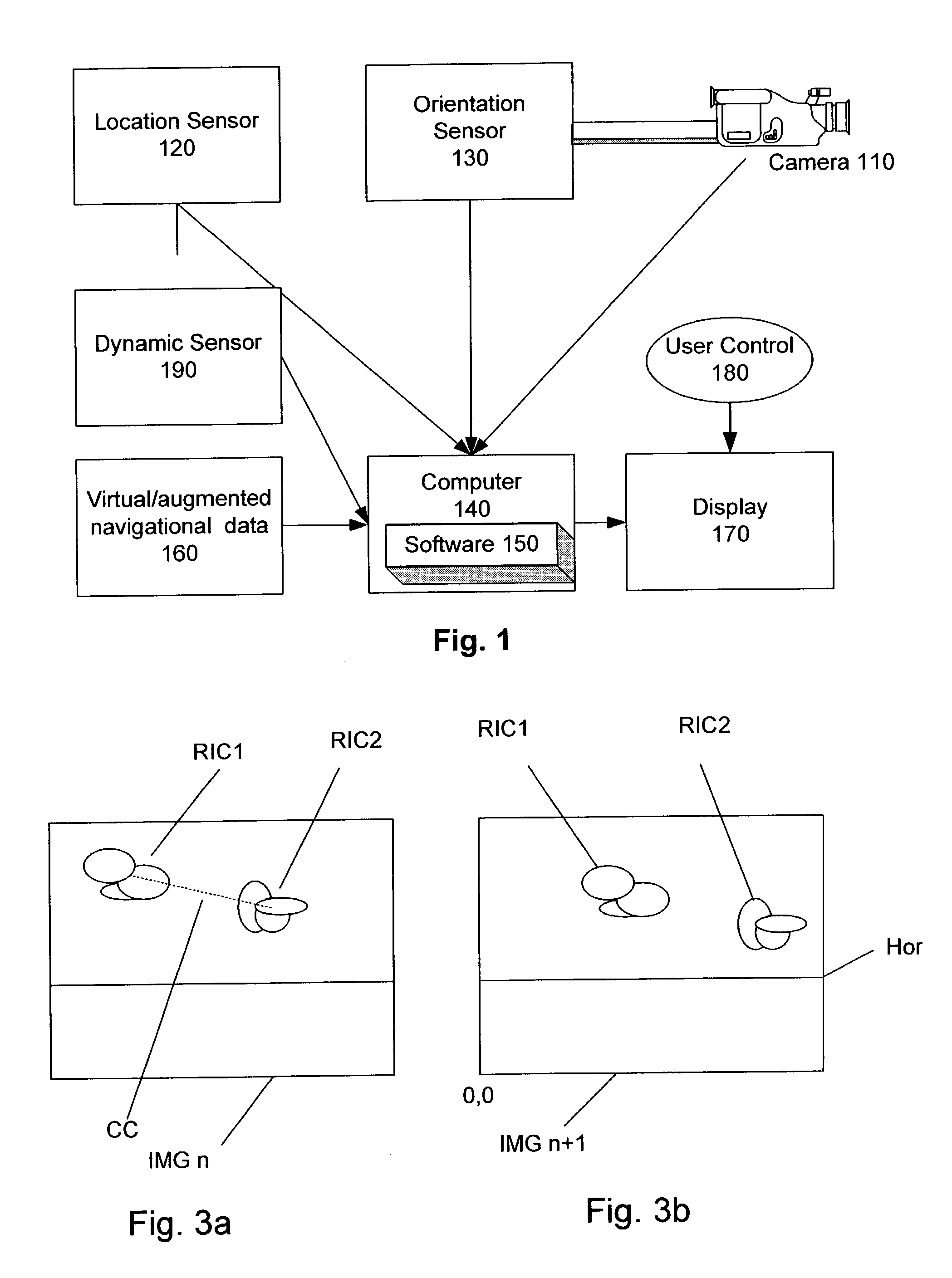
[0023]FIG. 1 depicts a general outline of a virtual or augmented reality system utilizing the preferred embodiment of the invention. A location sensor 120 is coupled to a computer 140, to provide periodic location information. A camera 110 is mounted on the ship, and thus directly or indirectly is coupled to an orientation sensor 130. The computer 140 is adapted to execute software 150 that amongst other things can perform the general block diagram of FIG. 2. In addition, in the preferred embodiment, the computer is coupled to a virtual reality and / or augmented reality data 160. Utilizing the LOR information, the computer can present the virtual / augmented reality on the display 170.

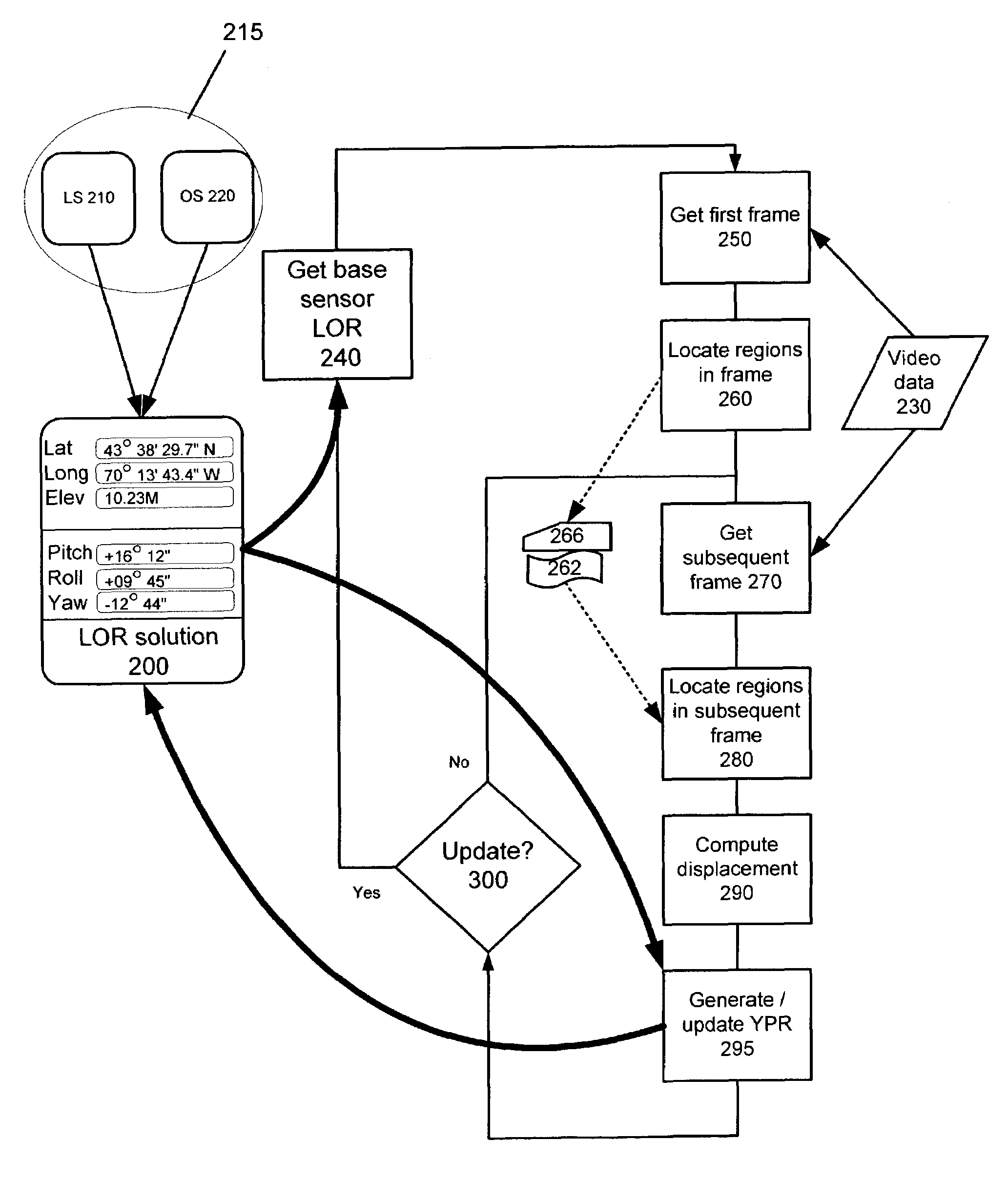
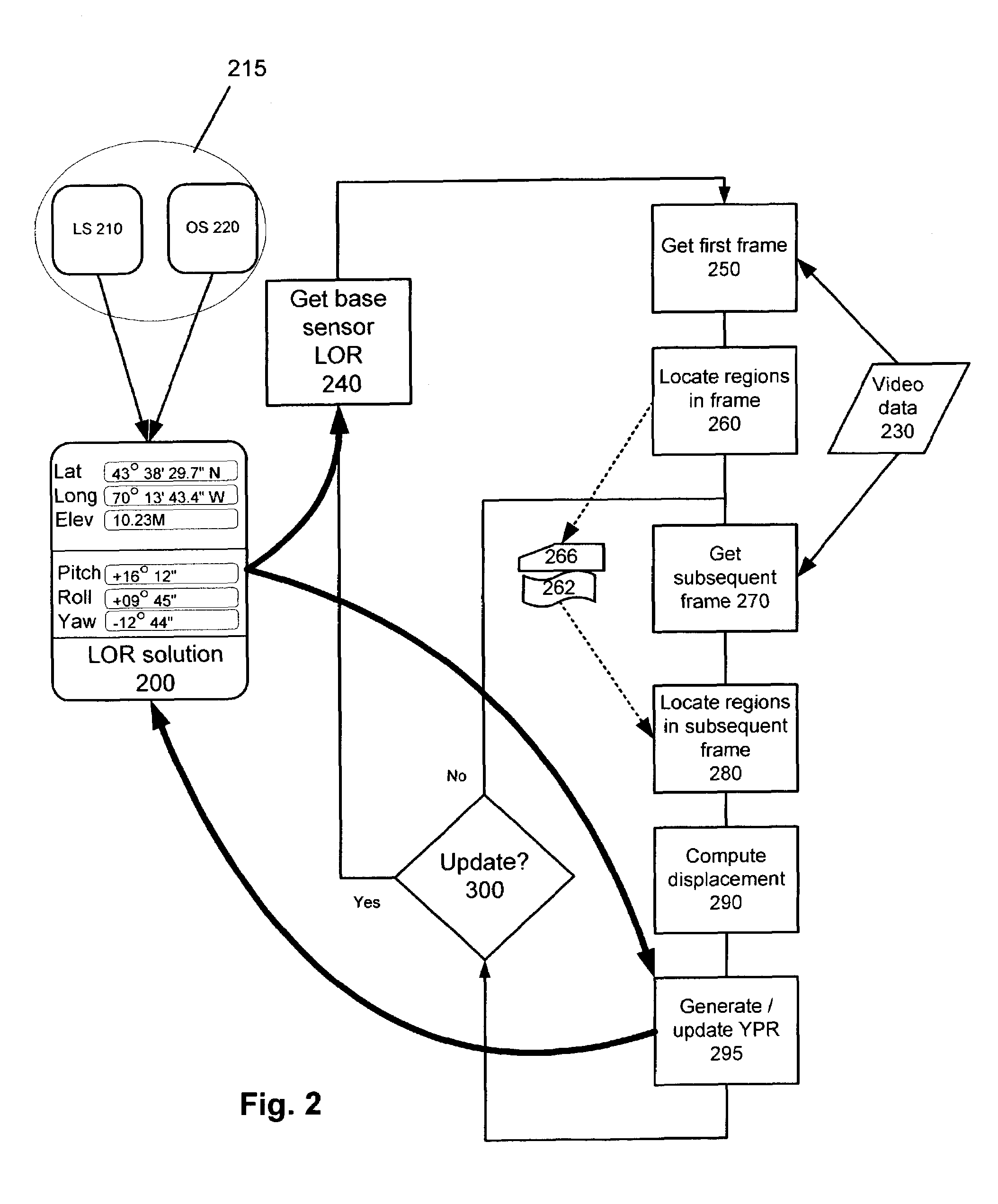
[0024]FIG. 2 shows an example of process flow of the preferred embodiment of the invention. Initial LOR data is collected from location sensor 210 and orientation sensor 220 in 240. The collected data becomes the current LOR solution 200. At the same time, or at sufficiently close temporal proximity, a ‘f...


PUM


Abstract

A navigation system utilizing augmented reality is provided which utilizes captured images to generate orientation information, wherein the pitch, yaw and roll are periodically derived from an inexpensive sensor, and in-between the periodical update, the pitch, roll, and yaw information are derived by capturing and image of the observed scene, identifying reference image components (RIC's) in a images and comparing those RIC's with subsequently captured images, to derive orientation information.

Description

RELATED APPLICATIONS[0001]This application is a continuation in parts of U.S. patent application Ser. No. 10 / 385,119, filed Mar. 10, 2003 now U.S. Pat. No. 7,071,970, which is hereby incorporated by reference in its entirety.FIELD OF THE INVENTION[0002]The invention relates generally to computer modeled reality and more particularly to a system and method for augmented reality based navigation system.BACKGROUND OF THE INVENTION[0003]Augmented Reality (commonly referred to by the acronym AR) combines the “real world” reality view with a virtual view. The “real world” reality is the actual observable scene, one captured by a camera, or another optical or electronic sensor. The observable scene is determined by the camera location, direction of view and limitations of the actual environment (such as darkness, fog, smoke, and the like). In AR, computer generated images are combined with an actual or a representation of the observable scene. A computer renders additions to the environmen...

Claims


Application Information

Patent Timeline
IPC IPC(8): H04N5/228H04N7/00H04N5/225G03B39/00G01C22/00G01C21/20
CPCG01C21/20
Inventor BENTON, CHARLES
Owner CBIP
Why Eureka
Try Eureka