Automobile navigation system and road map update system

a technology of automobile navigation and update system, which is applied in the direction of navigation, instruments, surveying and navigation, etc., can solve the problems of technique problems, vehicle position contains position-fix errors, etc., and achieve the effect of reducing the amount of data to be stored and high-accuracy running trails

Active Publication Date: 2009-07-21
DENSO CORP
View PDF28 Cites 48 Cited by
  • Summary
  • Abstract
  • Description
  • Claims
  • Application Information

AI Technical Summary

Benefits of technology

[0007]The present invention has been made with the foregoing taken into account. It is a first object of the present invention to provide an automobile navigation system in which, when a vehicle runs on a road not contained in road map data, its trail of running can be obtained with accuracy.
[0010]Under the above structure, a history storage unit stores history information related to the detection position and history information related to the map matching position. For this reason, comparison of these information makes it possible to easily and accurately determine, especially, a point at which a vehicle departs from a stored road and a point at which the vehicle comes back to a stored road. As a result, the trail of running of the vehicle from its departure from a stored road to its comeback to a stored road can be obtained with accuracy.
[0012]As mentioned above, when high-accuracy positioning is being carried out by the position detector, the history storage unit stores only position information related to the detection position from the high-accuracy positioning. Examples of high-accuracy positioning include RTK-GPS and VRS-GPS. Position-fix errors in the RTK-GPS and the VRS-GPS are between several centimeters and several tens of centimeters. Therefore, a highly accurate trail of running can be determined based on the history of position information of the detection position from high-accuracy positioning. When high-accuracy positioning is being carried out, only position information of the detection position from that high-accuracy positioning is stored. Thus, the amount of data to be stored can be reduced.

Problems solved by technology

However, whichever technique is adopted, the obtained relevant vehicle position contains a position-fix error.
However, this technique has a problem.

Method used


Image

  • Automobile navigation system and road map update system
  • Automobile navigation system and road map update system
  • Automobile navigation system and road map update system

Examples


first embodiment

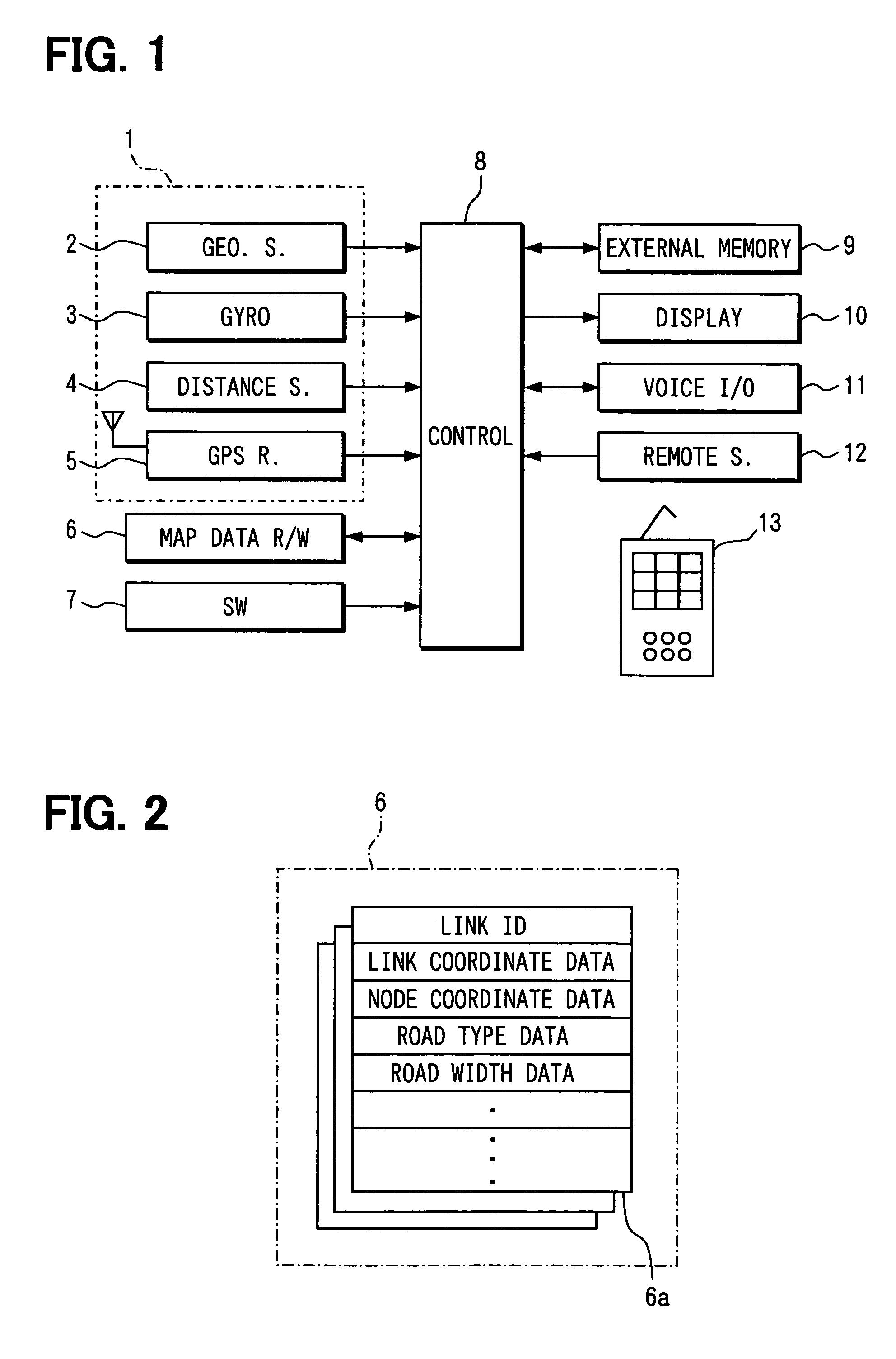
[0025]Hereafter, description will be given to an automobile navigation system provided in a vehicle in an embodiment of the present invention with reference to the drawings. FIG. 1 is a block diagram illustrating the general configuration of an automobile navigation system in this embodiment.

[0026]As illustrated in the figure, the automobile navigation system in this embodiment comprises: a position detector 1; a map data R / W device 6; an operation switch group 7; a control circuit 8 connected with these components; and an external memory 9, a display device 10, a voice input / output device 11, and a remote sensor 12 connected with the control circuit 8.

[0027]The control circuit 8 is constructed as an ordinary computer, and is provided therein with publicly known CPU, ROM, RAM, and I / O and bus lines that connect these components. In the ROM, programs executed by the control circuit 8 are written, and the CPU and the like perform computation according to these programs.
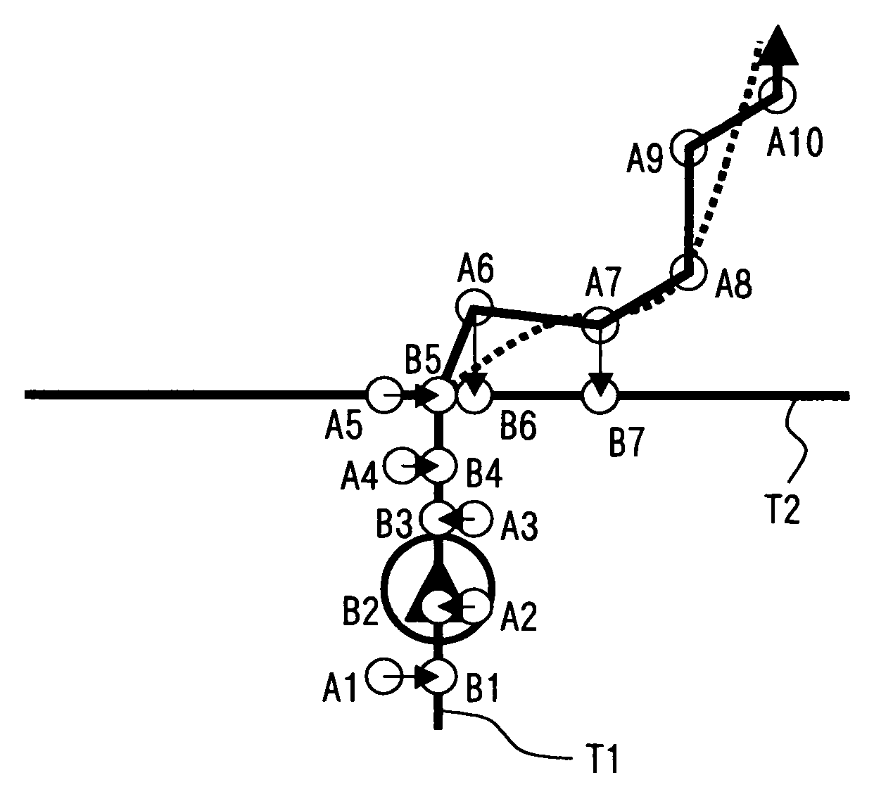
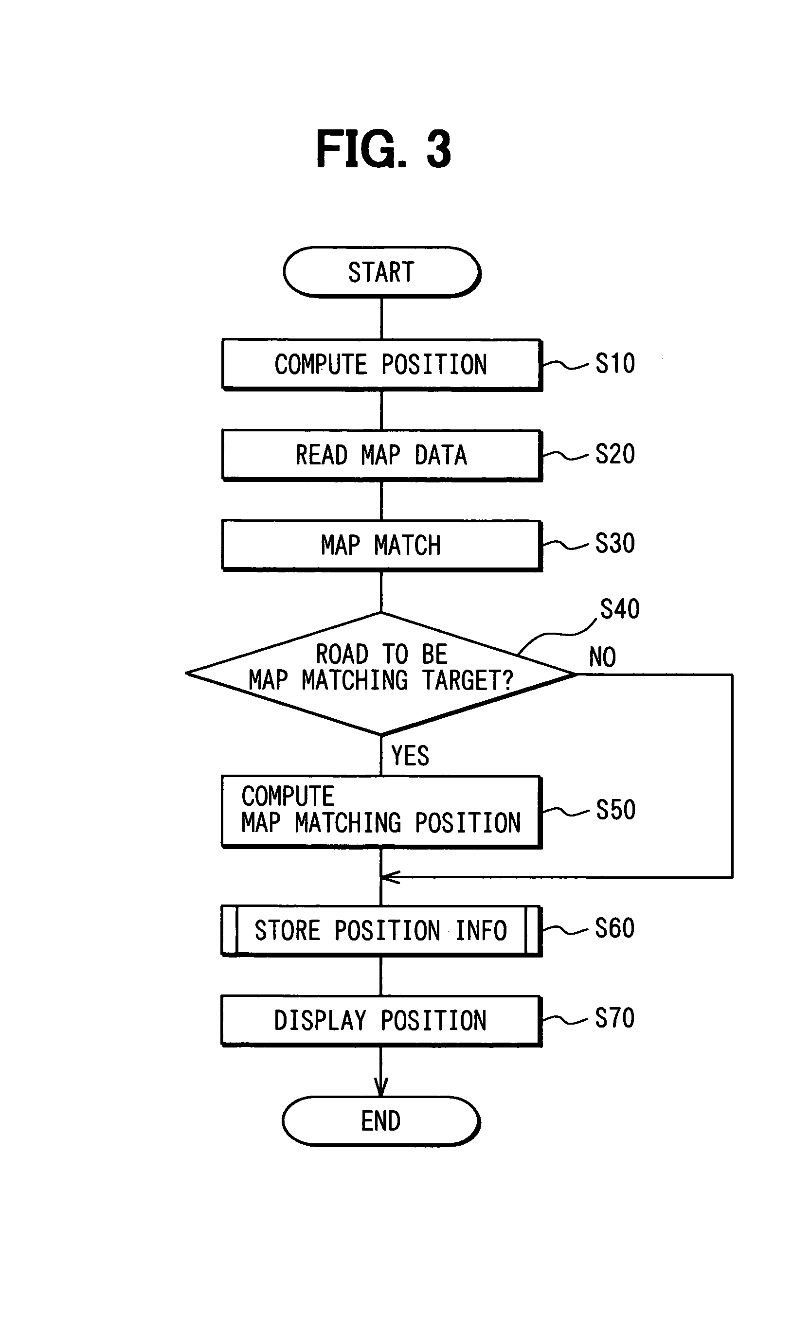
[0028]The posit...

second embodiment

[0087]Description will be given to an automobile navigation system in a second embodiment of the present invention. In the above-mentioned first embodiment, road data is generated in an automobile navigation system based on position information related to the relevant vehicle position and position information related to the map matching position. In this embodiment, this road data is acquired from an external management center that manages road map information.

[0088]FIG. 10 is a block diagram illustrating the configuration of an automobile navigation system in this embodiment. The same components as in the automobile navigation system in the first embodiment are marked with the same reference numbers.

[0089]As illustrated in FIG. 10, the automobile navigation system in this embodiment is additionally provided with a vehicle I / F 20 and a communication device 21 that are connected with an in-vehicle LAN for data communication with a management center, not shown. The other components ar...


PUM


Abstract

A navigation system in a vehicle stores position history information including position information related to a detection position detected by a position detector and position information related to a map matching position. The map matching position is obtained by matching the detection position with a point of a road in road map data. When the vehicle runs on a not-stored road that is not stored in the road map data, the navigation system determines a trail of running of the vehicle from departure from a stored road that is stored in the road map data to comeback into a stored road that is stored in the road map data, based on the stored position history information.

Description

CROSS REFERENCE TO RELATED APPLICATIONS[0001]This application is based on and incorporates herein by reference Japanese Patent Applications No. 2004-338003 filed on Nov. 22, 2004 and No. 2005-227062 filed on Aug. 4, 2005.FIELD OF THE INVENTION[0002]The present invention relates to an automobile navigation system and a road map delivery system wherein, when a vehicle runs on a road not contained in road map data, its trail of running can be obtained with accuracy and the new road can be added to the road map data utilizing the trail of running.BACKGROUND OF THE INVENTION[0003]For example, Patent Document 1 discloses a driving position display device in which, once a vehicle runs on a newly constructed road, data on the road can be stored. This driving position display device determines whether road data corresponding to a trail of running of the relevant vehicle is included in map data or not. When it is not included, the trail of running of the relevant vehicle is stored as configur...

Claims


Application Information

Patent Timeline
Patent Type & Authority Patents(United States)
IPC IPC(8): G01C21/32
CPCG01C21/32G01C21/3844G01C21/3815G01C21/3837
Inventor TAUCHI, NOBUTAKA
Owner DENSO CORP
Why Eureka
Try Eureka