Method for determining a track of a geographical trajectory

a geographical trajectory and track technology, applied in the field of geographical trajectory track determination, can solve the problems of unfavorable surveying methods, inaccurate measurements, and inability to apply error correction to measurement data without the aid of external information, so as to improve the accuracy of measurement data

Active Publication Date: 2009-11-24
REDUCT +1
View PDF11 Cites 8 Cited by
  • Summary
  • Abstract
  • Description
  • Claims
  • Application Information

AI Technical Summary

Benefits of technology

[0009]There is thus a need for a method for determining geographical data of a trajectory, by means of which the accuracy of the measurement data can be improved irrespective of the shape of the trajectory.

Problems solved by technology

A known problem of sensors such as accelerometers and gyroscopes is that for measurements over a long period of time, the measurements become inaccurate due to a drift of the sensors, i.e. a build-up of errors.
Some error correction is applied by referring to coordinates of a known survey endpoint and referencing to the velocity of the wireline on which the probe is suspended, but there is no teaching to apply error correction to the measurement data without the aid of this external information.
This error compensation is derived from comparing two measurements of the same physical quantity and is as such limited to a single measurement instrument.
Furthermore, this method requires a standstill of the sonde for rotating the gyro, which undesirably slows down the surveying method.
Such a proportional correction of measurements is however only possible without adversely affecting the accuracy of the data if the trajectory or borehole is substantially straight or has a substantially continuous bend.
In case of an arbitrary trajectory, such proportional correction is insufficient for obtaining data of sufficient accuracy.

Method used


Image

  • Method for determining a track of a geographical trajectory
  • Method for determining a track of a geographical trajectory
  • Method for determining a track of a geographical trajectory

Examples


Embodiment Construction

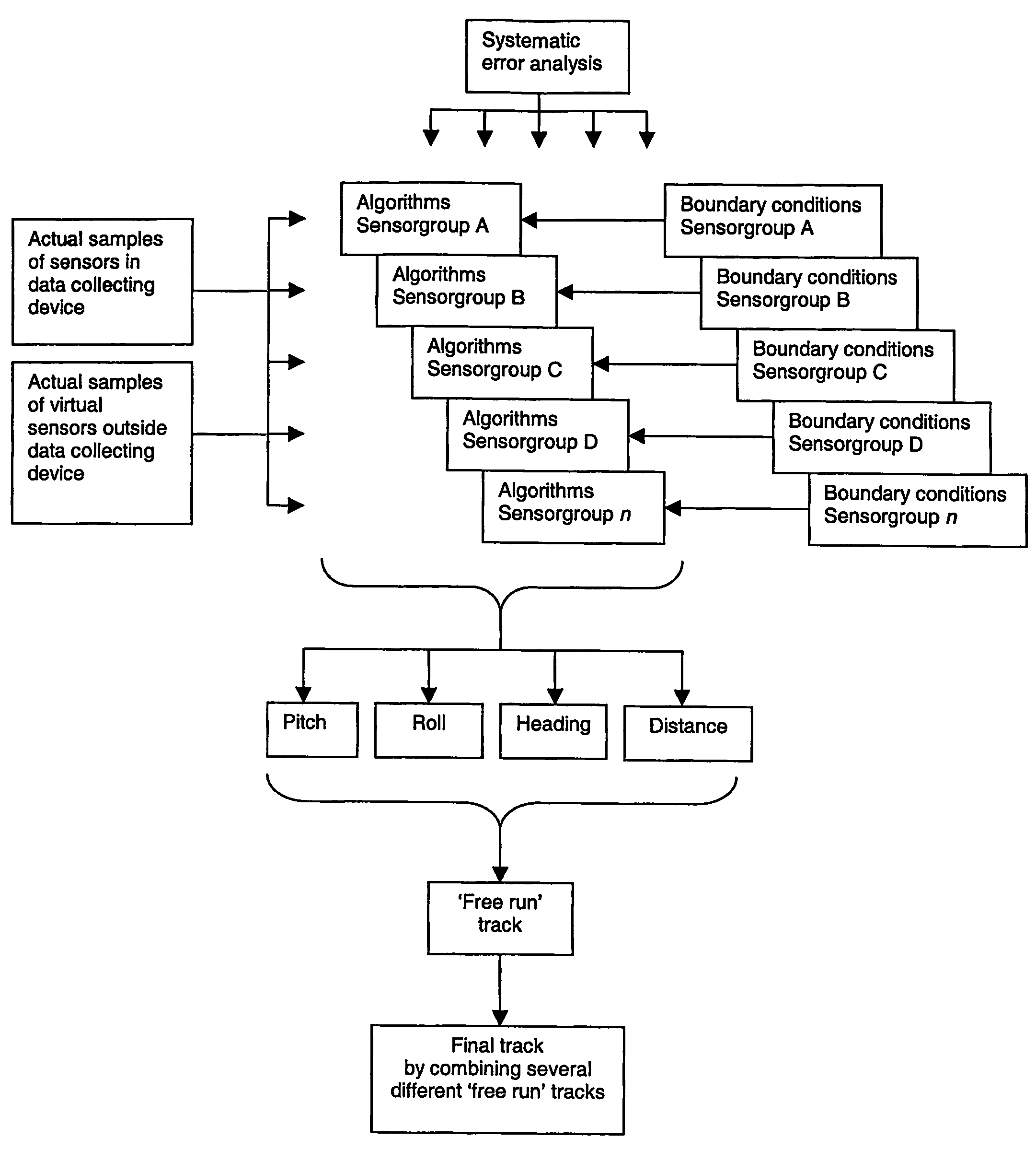
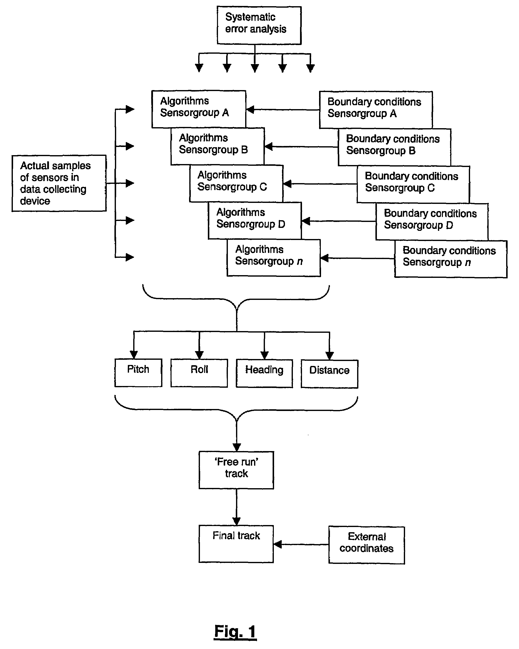
[0055]In the scheme shown in FIG. 1, it is shown how the measurement data, i.e. the actual samples of the sensors included in the data collecting device, are evaluated for obtaining the final track with the method of the invention. More particularly, the scheme shown in FIG. 1 shows that the method of the invention involves compensation on three levels, namely on the level of measurement data, on the level of profiles determined from the measurement data and on the level of the track determined from the profiles. Due to this compensation on three different levels, an accuracy of for example 0.05% of distance can be obtained.

[0056]The compensation on the level of measurement data comprises error compensation which is determined from a systematic error analysis. More particularly, this error compensation comprises a correction on the basis of mapping trajectory parameters, a correction for systematic error build-up and a correction for temperature variations.

[0057]The compensation on ...


PUM


Abstract

A method for determining a track of a geographical trajectory which has predetermined start and locations. A data collection device, which has onboard synchronized sensors, is moved between the start and end locations, and physical measurement data such as pitch, heading, roll and distance, is obtained and stored. Thereafter, the stored data is retrieved and mapped to determine error compensation. The physical measurement data, after error compensation, is used to determine the pitch profile, heading profile, distance profile and roll profile to ascertain the geographical trajectory track.

Description

CROSS-REFERENCE TO RELATED APPLICATIONS[0001]This application is the entry into the U.S. National Stage of PCT Application No. PCT / BE2003 / 000203 filed Nov. 24, 2003, and claims priority from U.S. Application No. 60 / 428,258 filed Nov. 22, 2002, and PCT Application No. PCT / BE02 / 00203, filed Dec. 30, 2002, the disclosures of both of which are hereby incorporated by reference.BACKGROUND OF THE INVENTION[0002]The present invention relates to a method for determining a track of a geographical trajectory.[0003]The track which is obtainable by the method of the invention can for example be used for including the location or path of a whole trajectory in a global coordinate system, for determining the length of a trajectory, for obtaining information about specified sections of a trajectory, for determining the geographical location of a specified event or other purposes.[0004]A method for determining a track is for example known from FR-A-2610100, which relates to a method and device for de...

Claims


Application Information

Patent Timeline
Patent Type & Authority Patents(United States)
IPC IPC(8): G01C21/00E21B47/022G01C21/16G01C23/00
CPCE21B47/022G01C23/00G01C21/183
Inventor VAN DEN BROECK, WIM
Owner REDUCT
Why Eureka
Try Eureka