Method of positioning perspective terrain on SVS primary flight displays using terrain database and radio altitude

Active Publication Date: 2010-05-11
ROCKWELL COLLINS INC
View PDF5 Cites 11 Cited by
  • Summary
  • Abstract
  • Description
  • Claims
  • Application Information

AI Technical Summary

Benefits of technology

[0008]The present invention is particularly advantageous for close to ground operations, where traditio

Problems solved by technology

The greatest contributing factor to most fatal worldwide airline and general aviation crashes is limited visibility.
However, the computed navigation solution often does not have enough vertical accuracy, especially while the aircraft is close (less than 100 meters) to the ground.
GNSS gives very good lateral position or latitude and longitude, but is much less accurate for altitude.
This inaccu

Method used


Image

  • Method of positioning perspective terrain on SVS primary flight displays using terrain database and radio altitude
  • Method of positioning perspective terrain on SVS primary flight displays using terrain database and radio altitude
  • Method of positioning perspective terrain on SVS primary flight displays using terrain database and radio altitude

Examples


Embodiment Construction

[0016]Reference will now be made in detail to exemplary embodiments of the invention, examples of which are illustrated in the accompanying drawings.

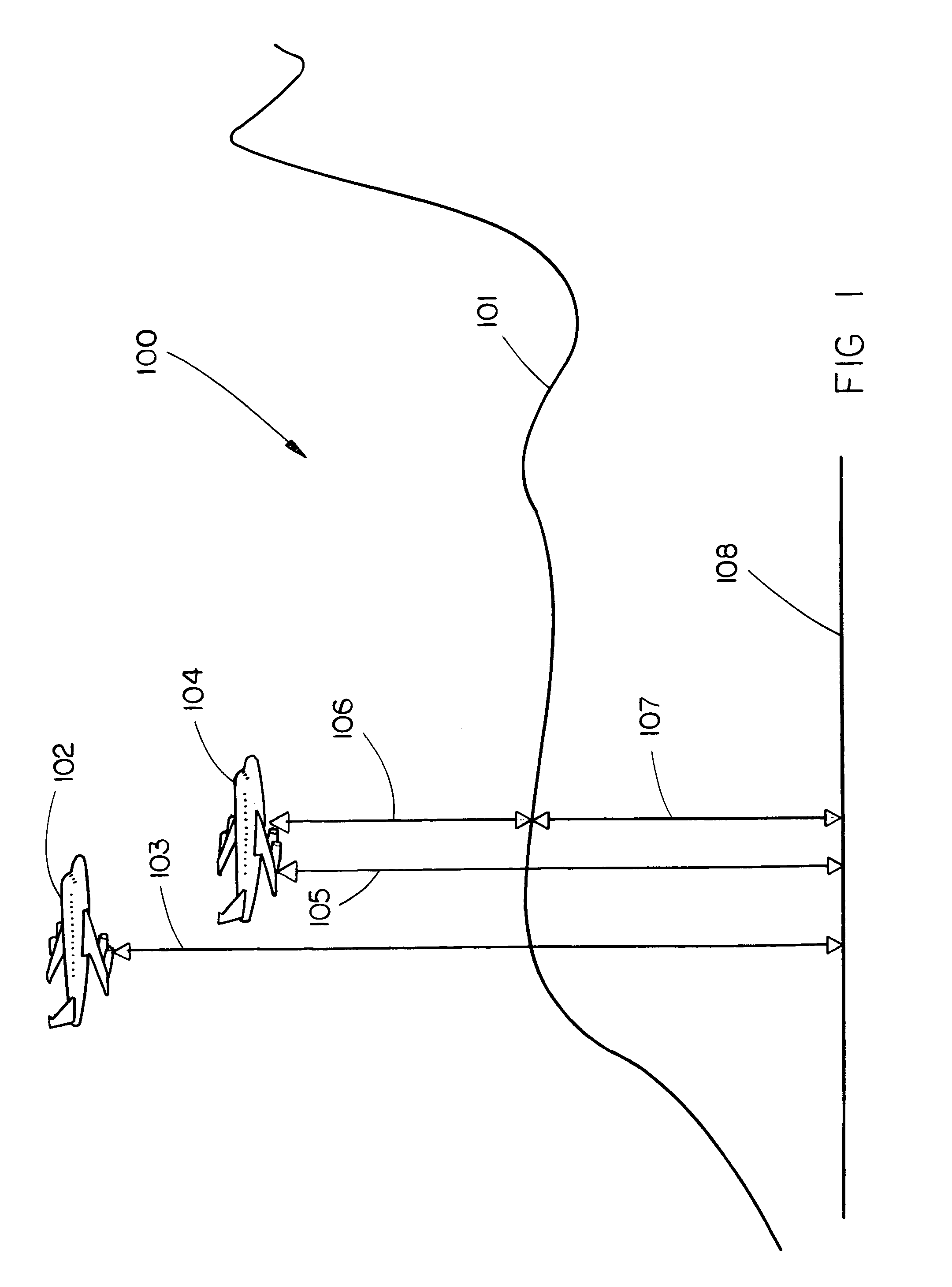
[0017]Referring generally to FIG. 1; a synthetic view 100 is illustrated showing terrain 101, mean sea level (MSL) 108, and two representations of an aircraft 102 and 104. Double arrow-headed line 105 illustrates the actual altitude of the aircraft. Double arrow-headed line 103 illustrates an estimated altitude of the aircraft derived from a barometric altimeter or GNSS (Global Navigation Satellite System). Double arrow-headed line 106 illustrates the height of the aircraft above terrain 101 derived from, but not limited to, a radio altimeter or laser rangefinder. Double arrow-headed line 107 illustrates the elevation of terrain 101 above MSL 108 derived from a terrain database. Aircraft representation 102 illustrates the presentation of the relation between the aircraft and terrain when the terrain has been positioned based upon a navi...


PUM


Abstract

The present invention is directed to a method of positioning perspective terrain on a SVS (Synthetic Vision System) based on a navigation solution, the vertical component of which is calculated utilizing a terrain database and sensing unit (which provides height above terrain). The terrain database provides elevation of terrain above MSL. A sensor, such as a GNSS sensor, may be utilized to calculate the navigation solution. In alternative embodiments, the navigation solution is calculated differently based upon the phase of flight. In one, the vertical component calculation utilizes the sensing unit at or below the sensing unit's rated altitude. In another, vertical component calculation blends the sensing unit with the sensor. The blending may be based upon percentages based upon altitude or utilize filtering such as Kalman filtering. The present invention is particularly advantageous for close to ground operations, insuring perspective terrain will stay consistent with the real world.

Description

FIELD OF THE INVENTION[0001]The present invention relates generally to guidance instruments and more particularly to a method of positioning perspective terrain on SVS (synthetic vision systems) primary flight displays using terrain database and radio altitude.BACKGROUND OF THE INVENTION[0002]The greatest contributing factor to most fatal worldwide airline and general aviation crashes is limited visibility. Synthetic vision systems (SVS) have been developed to offer pilots a clear, electronic picture of what is ahead, regardless of time and weather conditions. SVS also presents data (such as terrain, obstacles, air traffic, landing and approach patterns, and other relevant information) as part of the picture in a way that allows pilots to easily synthesize and deal with all information relevant to flight (referred to as situational awareness). SVS typically include a primary flight display (PFD) which displays all information critical to flight, a multi-function display (MFD) which ...

Claims


Application Information

Patent Timeline
IPC IPC(8): G01C21/00
CPCG01C23/00G08G5/0086G08G5/0052
Inventor WENGER, JASON C.BARBER, SARAHPOSTNIKOV, ALEXPELZER, ANDREW M.
Owner ROCKWELL COLLINS INC
Why Eureka
Try Eureka