Supercharge Your Innovation With Domain-Expert AI Agents!

Positioning device, control method of positioning device, control program for positioning device, and computer-readable recording medium having positioning device controlling program recorded therein

a positioning device and control method technology, applied in surveying and navigation, navigation instruments, instruments, etc., can solve the problems of large positioning calculation error, inability to position itself, and deviating from the pseudo-range to be longer, so as to reduce the load of storage capacity, simple construction, and high precision

Active Publication Date: 2011-03-15
SEIKO EPSON CORP
View PDF24 Cites 11 Cited by
  • Summary
  • Abstract
  • Description
  • Claims
  • Application Information

AI Technical Summary

Benefits of technology

The device achieves high-precision positioning in multipath recurrent districts with a simple construction by using elevation information to reduce positioning errors and minimize storage load, and also maintains precision outside such districts.

Problems solved by technology

As a result, there is a problem that the pseudo range is deviated to be longer, and a large error occurs in the positioning calculation.
However, in an urban area where tall buildings stand side by side, there are some cases where it is impossible to receive direct waves from GPS satellites whose number is needed for the positioning, and there is a problem that if the multipath is excluded, the positioning itself would be impossible.
Here, when a multipath is excluded, there is a case where satellite signals from three or more GPS satellites cannot be used and thus it is impossible to carry out the positioning.
On the other hand, when a multipath is used for the positioning, there is a case where the error of the positioning result is extremely increased.
Therefore, the positioning device can generate the elevation information using present position information having a small positioning error even in the multipath recurrent district.
In addition, the elevation information owned by the positioning device is limited to the elevation information of the multipath recurrent district and thus the load of the storage capacity of the positioning device is extremely small.

Method used


Image

  • Positioning device, control method of positioning device, control program for positioning device, and computer-readable recording medium having positioning device controlling program recorded therein
  • Positioning device, control method of positioning device, control program for positioning device, and computer-readable recording medium having positioning device controlling program recorded therein
  • Positioning device, control method of positioning device, control program for positioning device, and computer-readable recording medium having positioning device controlling program recorded therein

Examples


Embodiment Construction

[0046]Embodiments according to the invention will be described hereunder with reference to the accompanying drawings. The embodiments described hereunder are preferable embodiments of the invention, and thus various technically preferable limitations are provided thereto. However, the scope of the invention is not limited to these embodiments except when there is particularly some description limiting the invention.

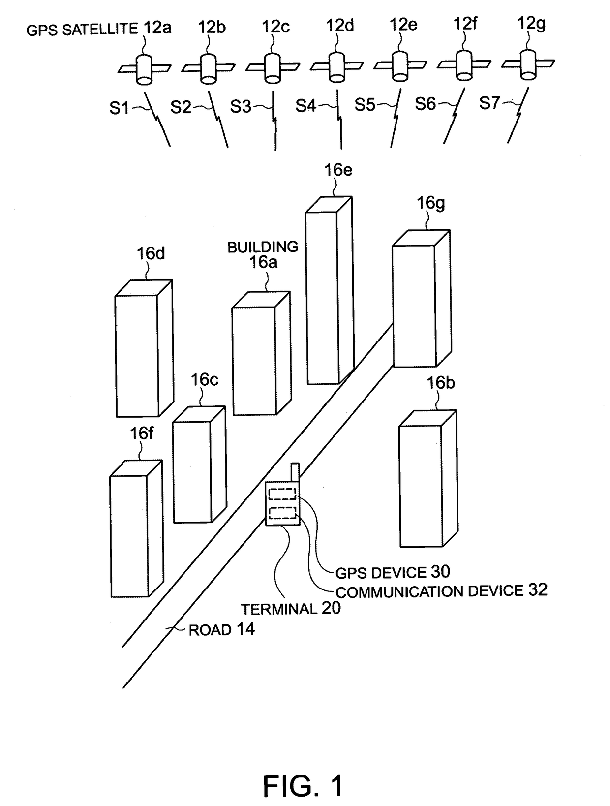
[0047]FIG. 1 is a schematic diagram showing a terminal 20, etc. according to an embodiment of the invention.

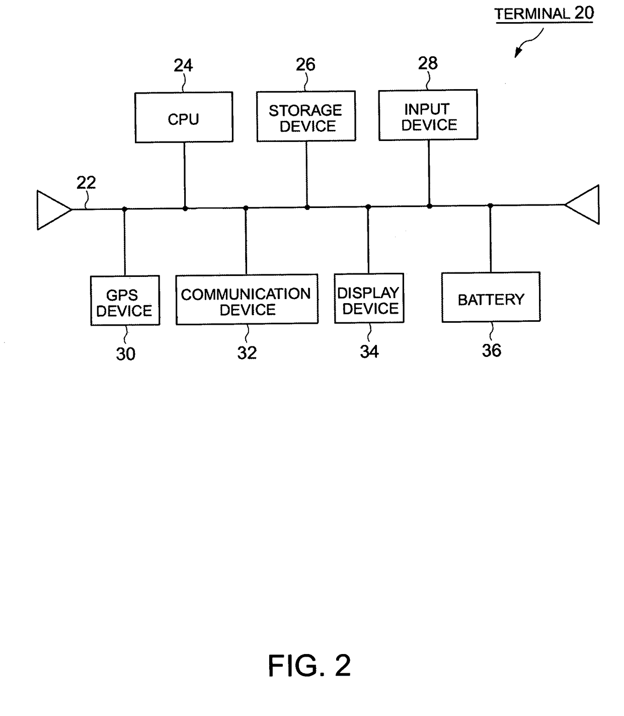
[0048]The terminal 20 is an example of a positioning device. As shown in FIG. 1, the terminal 20 has a GPS device 30. The terminal 20 can receive through the GPS device 30 satellite signals, for example, signals S1, S2, S3, S4, S5, S6 and S7 from plural positioning satellites, for example, GPS satellites 12a, 12b, 12c, 12d, 12e, 12f and 12g, respectively.

[0049]For example, the terminal 20 is located in the neighborhood of a road 14 located in an urban city of Tokyo,...


PUM


Abstract

A positioning device for receiving a satellite signal corresponding to a signal from a positioning satellite including a multipath recurrent district elevation information storing unit for storing multipath recurrent district elevation information indicating the elevation of a multipath recurrent district as elevation information of plural divisional areas, an elevation information obtaining position information generating unit for receiving the satellite signals and generating elevation information obtaining position information to obtain the elevation information, an elevation information obtaining unit for obtaining the elevation information of the divisional area corresponding to the elevation information obtaining position information and an elevation information using present position information generating unit for generating elevation information using present position information indicating the present position on the basis of the satellite signals and the elevation information.

Description

BACKGROUND[0001]1. Technical Field[0002]The present invention relates to a positioning device for carrying out positioning on the basis of signals from positioning satellites, a control method for the positioning device, a control program for the positioning device, and a computer-readable recording medium in which the control program for the positioning device is recorded.[0003]2. Related Art[0004]There has been practically used a positioning system for detecting the present position of a GPS receiver by using a satellite navigation system such as GPS (Global Positioning System) or the like.[0005]The GPS receiver receives signal electric waves from three or more GPS satellites (hereinafter referred to satellite signals), for example, and calculates the distance between each GPS satellite and the GPS receiver (hereinafter referred to as pseudo range) on the basis of the difference between the transmission time of the satellite signal from each GPS satellite and the reception time of...

Claims


Application Information

Patent Timeline
Patent Type & Authority Patents(United States)
IPC IPC(8): G01S19/22G01C21/00G01S19/42
CPCG01S19/22G01S19/13
Inventor TERASHIMA, MAHOKURATA, TOMOYU
Owner SEIKO EPSON CORP
Features
  • R&D
  • Intellectual Property
  • Life Sciences
  • Materials
  • Tech Scout
  • Unparalleled Data Quality
  • Higher Quality Content
  • 60% Fewer Hallucinations
Learn More