Methods, apparatuses, and computer program products for traffic data aggregation using virtual trip lines and a combination of location and time based measurement triggers in GPS-enabled mobile handsets

a technology of traffic data and triggers, which is applied in the field of methods, apparatuses and computer program products for traffic data aggregation using virtual trip lines and a combination of location and time based measurement triggers in gps-enabled mobile handsets. it can solve the problems of compromising the privacy of the driver, requiring a sophisticated fixed infrastructure, and expensive loop detectors used to detect traffic conditions. , to achieve the effect of preserving user/subscriber privacy, enhancing

Active Publication Date: 2011-03-22
NOKIA TECH OY
View PDF6 Cites 32 Cited by
  • Summary
  • Abstract
  • Description
  • Claims
  • Application Information

AI Technical Summary

Benefits of technology

[0010]The exemplary embodiments of the invention are capable of utilizing virtual trip lines which can be dynamically defined to correspond to any geographic area such as for example roads and may be used to monitor traffic in a traffic monitoring system. The traffic monitoring system of the exemplary embodiments of the invention fosters efficiency and seeks to preserve a user / subscriber's privacy by defining virtual trip lines in privacy-insensitive areas. By randomly delaying a time period in which an electronic device reports data associated with crossing or traversing the virtual trip line privacy-sensitive data may be made more secure making it harder for an untrusted server to retrieve one or more reports with the hopes of correlating the reports to track and monitor a user of the electronic device. The virtual trip lines may contain data requiring that the electronic device only report anonymous information, when the device traverses a virtual trip line which provides enhanced security of the user's privacy.
[0015]In yet another exemplary embodiment, a method for facilitating traffic monitoring is provided. The method includes generating one or more geometrical boundaries defined with data. Each geometrical boundary comprises a plurality of location descriptors and each of the location descriptors and the geometrical boundaries correspond to a geometrical area of the world. The method further includes sending the one or more geometrical boundaries to a terminal which uses the data to trigger generation of information that is associated with the terminal and the geographic area. For example, the geometrical area may correspond to a segment of a road and upon expiration of the predetermined time period the terminal may generate information identifying its location, the location it is traveling, the speed or velocity that it is traveling and any other suitable information.

Problems solved by technology

However, usage of loop detectors, consisting of physical inductive coils that are located on roadways and cameras to detect traffic conditions are expensive and may require a sophisticated fixed infrastructure.
While probe vehicles may enhance a driver's travel experience, they are vulnerable to compromising the privacy of the driver.
In this regard, compromising the integrity of the driver's privacy may limit the number of individuals willing to subscribe to a real-time traffic monitoring service.
Anonymous collection of data samples in updates (e.g., where the driver's identity is not provided) sent from the driver's vehicle does not solve the privacy problem since these samples are still vulnerable to place identification (e.g., driver's home) and target tracking of the vehicle due to the spatial and temporal correlation between successive updates.
Another problem with existing traffic monitoring services which typically use installed sensors such as loop detectors and cameras to detect the location of a vehicle arises in situations where there is a significant traffic slowdown between two measurement locations which may utilize installed sensors to determine the location of the vehicle.
Due to the traffic slowdown between the two measurement locations, there may be a long time interval in which the vehicle sends an update to the traffic monitoring service provider.
For instance, if the traffic in which the vehicle is driving slows down or comes to a complete stop, there may not be any additional update(s) reported to the traffic monitoring service by the vehicle for a long time.
In this regard, the traffic monitoring service provider may be unable to detect a slowdown in traffic flow which the traffic monitoring service provider typically would like to detect.
Another problem that arises from this inability to detect the traffic slowdown relates to the freshness of data along the roadway where there is a long distance between update measurement locations.
While time based measurements continue to report data even if traffic comes to a complete stop or moves very slow, traffic monitoring services utilizing time based measurements suffer from other drawbacks.
For instance, in a traffic monitoring service that utilizes time based measurements, as opposed to location based measurements, a vehicle may generate random updates relating to traffic data, which oftentimes creates unnecessary network usage because an update may not be needed by the traffic monitoring service provider during the particular time interval in which the update is generated.
As such, a drawback of time based measurements in a traffic monitoring service is that traffic data which may be useless is often generated which wastes network resources.
Additionally, usage of time based measurements in a traffic monitoring service often results in invasion of one's privacy given that the vehicle may generate an update identifying sensitive information such as the vehicle's location, speed, etc. during a random time period in which the update is generated.
In this regard, utilizing time based measurements in traffic monitoring services suffer from the drawback of releasing potential sensitive or private information relating to the user of the vehicle.

Method used


Image

  • Methods, apparatuses, and computer program products for traffic data aggregation using virtual trip lines and a combination of location and time based measurement triggers in GPS-enabled mobile handsets
  • Methods, apparatuses, and computer program products for traffic data aggregation using virtual trip lines and a combination of location and time based measurement triggers in GPS-enabled mobile handsets
  • Methods, apparatuses, and computer program products for traffic data aggregation using virtual trip lines and a combination of location and time based measurement triggers in GPS-enabled mobile handsets

Examples


Embodiment Construction

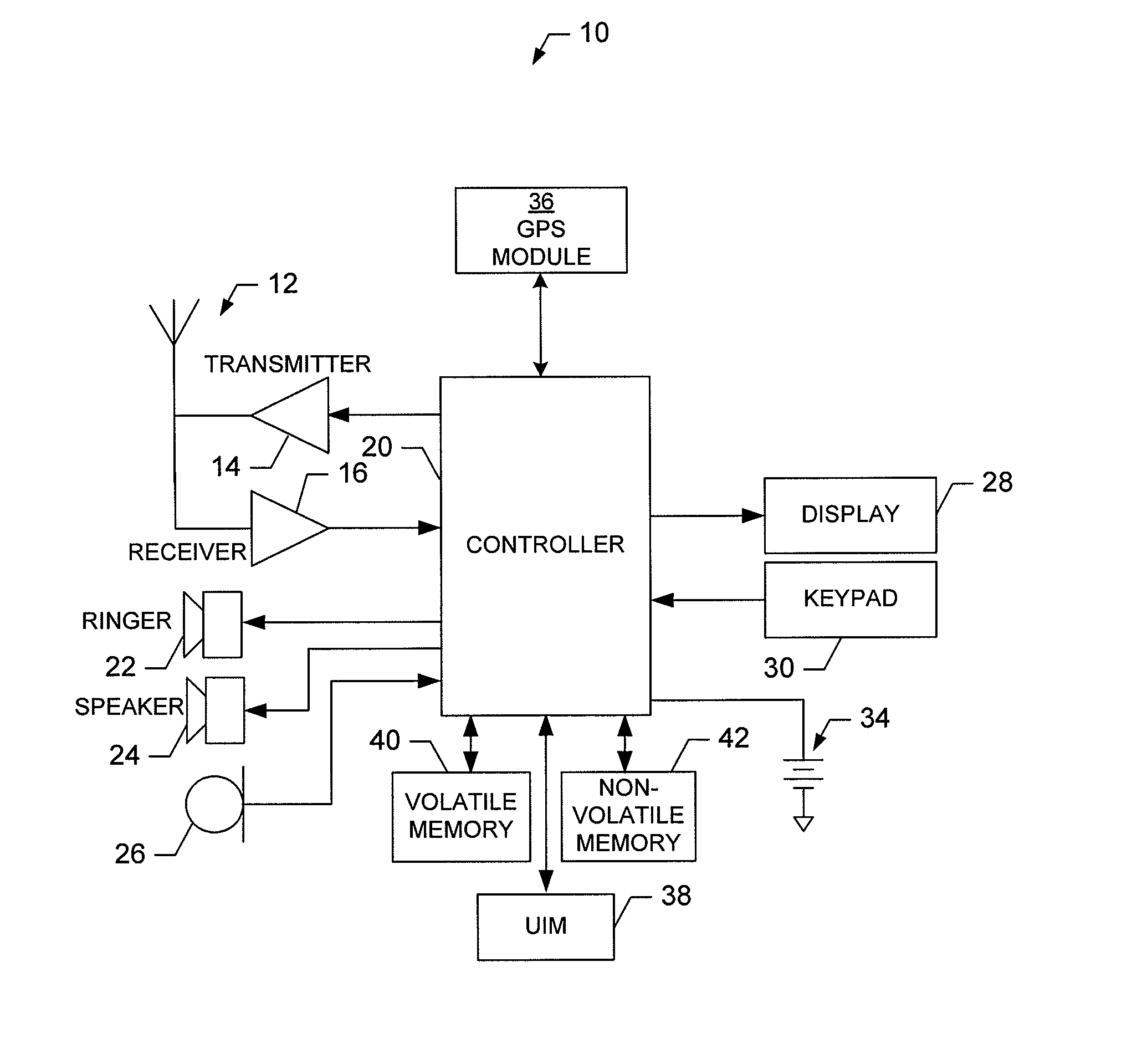
[0025]The present invention now will be described more fully hereinafter with reference to the accompanying drawings, in which some, but not all embodiments of the inventions are shown. Indeed, these inventions may be embodied in many different forms and should not be construed as limited to the embodiments set forth herein; rather, these embodiments are provided so that this disclosure will satisfy applicable legal requirements. Like numbers refer to like elements throughout.

[0026]FIG. 1 illustrates a block diagram of a mobile terminal 10 that would benefit from the present invention. It should be understood, however, that a mobile telephone as illustrated and hereinafter described is merely illustrative of one type of mobile terminal that would benefit from the present invention and, therefore, should not be taken to limit the scope of the present invention. While several embodiments of the mobile terminal 10 are illustrated and will be hereinafter described for purposes of exampl...


PUM


Abstract

A device for determining the traffic conditions between measurement locations associated with a roadway is provided. The device includes a processor that is capable of determining when a specified measurement location is passed or traversed and measure data as well as start a time period. If a device is traveling towards another specified measurement location but does not reach the location before the time period expires, a new measurement update may be sent by the device to a server. The information in this update may be utilized by the server to determine that there is a slowdown or blockage in traffic and / or that there is a traffic jam between the measurement locations. The device is capable of receiving a traffic update(s) from the server which may specify traffic conditions between the measurement locations. The traffic conditions may indicate that there is a traffic slowdown / blockage between the measurement locations.

Description

CROSS-REFERENCE TO RELATED APPLICATIONS[0001]This application is a continuation-in-part of U.S. patent application Ser. No. 11 / 948,779, filed on Nov. 30, 2007, the contents of which are incorporated herein by reference.FIELD OF THE INVENTION[0002]Embodiments of the present invention relate generally to utilizing virtual trip lines (VTLs) and global positioning system (GPS) enabled mobile devices of vehicle drivers to infer real-time traffic information on roadways and more particularly, relate to a method, device, and computer program product for preserving the privacy of the vehicle drivers using the GPS enabled mobile devices in a real-time traffic monitoring system.BACKGROUND OF THE INVENTION[0003]The modern communications era has brought about a tremendous expansion of wireline and wireless networks. Computer networks, television networks, and telephony networks are experiencing an unprecedented technological expansion, fueled by consumer demand. Wireless and mobile networking t...

Claims


Application Information

Patent Timeline
Patent Type & Authority Patents(United States)
IPC IPC(8): G06F19/00
CPCG08G1/0104G08G1/207
Inventor SUTTER, DAVID WILLIAMJACOBSON, QUINNHOH, BAIKANNAVARAM, MURALI
Owner NOKIA TECH OY
Why Eureka
Try Eureka