Auto-referenced system and apparatus for three-dimensional scanning

a three-dimensional scanning and reference system technology, applied in the field of three-dimensional scanning, can solve the problems of limiting the quality of integrated data, subject to speckle noise, and using positioning devices that significantly increase the complexity and cost of the apparatus,

Active Publication Date: 2011-03-22
CREAFORM INC
View PDF21 Cites 233 Cited by
  • Summary
  • Abstract
  • Description
  • Claims
  • Application Information

AI Technical Summary

Benefits of technology

[0013]It would thus be of great interest to simultaneously scan and model the object's surface while accumulating a second model of the positioning features in real-time using a single hand-held sensor. Furthermore, by fixing additional physical targets as positioning features on an object, it would be possible to hold the object in one hand while holding the scanner in the second hand without depending on the object's surface geometry for the quality of the calculated sensor positions.
[0014]It is therefore an aim of the present invention to provide a 3D laser scanning system that can simultaneously measure the 3D surface geometry and measure a model of a set of positioning features for positioning.
[0020]Further, in accordance with the present invention, there is provided a method for obtaining 3D surface points of an object in an object coordinate system using an hand-held device, said method comprising providing a projection pattern on said object; securing a set of positioning features on said object such that said object and, accordingly, said object coordinate system can be moved in space while said positioning features stay still on said object; acquiring a pair of 2D images of said projection pattern on said object and of at least part of said set of positioning features, an acquiring position of said pair of 2D images being defined in a sensing device coordinate system; extracting, from said pair of 2D images, a pair of sets of 2D surface points originating from said projection pattern and a pair of sets of 2D positioning features originating from said at least part of said set of positioning features; calculating a set of 3D surface points in said sensing device coordinate system using said pair of sets of 2D surface points; calculating a set of 3D positioning features in said sensing device coordinate system using said pair of sets of 2D positioning features; computing transformation parameters for characterizing a current spatial relationship between said sensing device coordinate system and said object coordinate system, by matching corresponding features between said set of calculated 3D positioning features in said sensing device coordinate system and a set of reference 3D positioning features in said object coordinate system, said reference 3D positioning features being cumulated from previous observations; transforming said set of calculated 3D surface points in said sensing device coordinate system into a set of transformed 3D surface points in said object coordinate system using said transformation parameters; transforming said set of calculated 3D positioning features in said sensing device coordinate system into a set of transformed 3D positioning features in said object coordinate system using said transformation parameters; and cumulating said set of transformed 3D positioning features to provide and augment said set of reference 3D positioning features.
[0023]A system, apparatus and method for three-dimensional scanning and digitization of the surface geometry of objects are claimed. The system comprises a hand-held apparatus that is auto-referenced. The system is auto-referenced since it does not need any positioning device to provide the 6 degree of freedom transformations that are necessary to integrate 3D measurements in a global coordinate system while the apparatus is manipulated to scan the surface. The system continuously calculates its own position and orientation from observation while scanning the surface geometry of an object. To do so, the system exploits a triangulation principle and integrates an apparatus that captures both surface points originating from the reflection of a projected laser pattern on an object's surface and 2D positioning features originating from the observation of target positioning features. A significant advantage of the described system is its capability to implement a method that makes it possible to simultaneously build and match a 3D representation of the positioning features while accumulating the 3D surface points describing the surface geometry.

Problems solved by technology

This type of projector with coherent light offers good depth of field characteristics but is subject to speckle noise.
Using a hand-held system, the main challenge is to continuously estimate the position and orientation (6 degrees of freedom) of the apparatus in a global coordinate system fixed relative to the object.
Using a positioning device significantly increases the complexity and cost of the apparatus.
It is also cumbersome in some cases or noisy enough to limit the quality of the integrated data.
This idea of integrating the computation of the position directly into the system while exploiting measurement is interesting but these systems depend completely on the geometry of the object and it is not possible to ensure that an accurate estimate of the pose be maintained.
For instance, objects whose geometry variation is weak or objects with local symmetries with spherical, cylindrical or planar shapes, lead to non constant quality in positioning.
These positioning features can be natural points in the scene but in many cases their density or quality is not sufficient and target positioning features are set in the scene.
Nevertheless, although the system is freely hand-held, it is limited since it does not build a model of the positioning feature points dynamically; there must exist a single viewpoint where all—three—positioning feature points are visible.

Method used


Image

  • Auto-referenced system and apparatus for three-dimensional scanning
  • Auto-referenced system and apparatus for three-dimensional scanning
  • Auto-referenced system and apparatus for three-dimensional scanning

Examples


Embodiment Construction

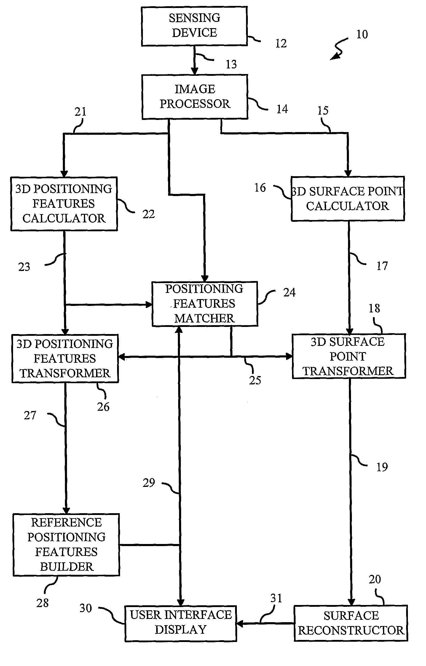
[0028]Referring to FIG. 1, the 3D surface scanning system is generally shown at 10.

Sensing Device

[0029]The system comprises a sensing device 12 described in more details thereafter in this description. The sensing device 12 collects and transmits a set of images 13, namely a frame, of the observed scene to an image processor 14. These images are collected from at least two viewpoints where each of these viewpoints has its own center of projection. The relevant information encompassed in the images results from the laser projection pattern reflected on the object's surface as well as positioning features that are used to calculate the relative position of the sensing device with respect to other frame captures. Since all images in a given frame, are captured simultaneously and contain both positioning and surface measurements, synchronisation of positioning and surface measurement is implicit.

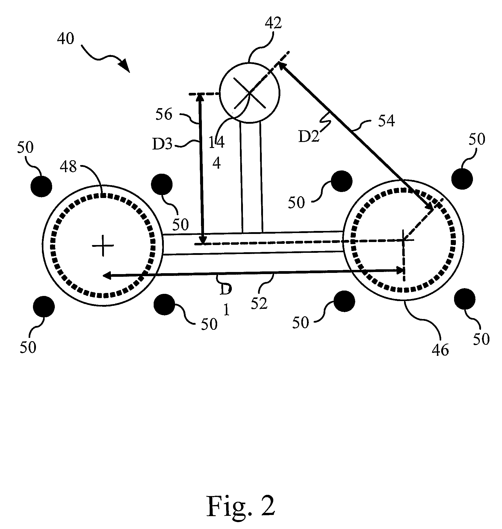
[0030]The positioning features are secured on the object such that the object can be moved i...


PUM


Abstract

A system, apparatus and method for three-dimensional scanning and digitization of the surface geometry of objects are claimed. The system includes a hand-held apparatus that is auto-referenced. The system is auto-referenced since it does not need any positioning device to provide the 6 degree of freedom transformations that are necessary to integrate 3D measurements in a global coordinate system while the apparatus is manipulated to scan the surface. The system continuously calculates its own position and orientation from observation while scanning the surface geometry of an object. To do so, the system exploits a triangulation principle and integrates an apparatus that captures both surface points originating from the reflection of a projected laser pattern on an object's surface and 2D positioning features originating from the observation of target positioning features.

Description

CROSS-REFERENCE TO RELATED APPLICATIONS[0001]The present application is a 35 U.S.C. 371 national phase entry of International Patent Application number PCT / CA2006 / 000370 filed Mar. 13, 2006 and amended under Article 19 during the International Phase, which claims priority of U.S. provisional patent application No. 60 / 660,471 filed Mar. 11, 2005, all of which are hereby incorporated by reference.TECHNICAL FIELD[0002]The present invention generally relates to the field of three-dimensional scanning of an object's surface geometry, and, more particularly, to a portable three-dimensional scanning apparatus for hand-held operations.BACKGROUND OF THE INVENTION[0003]Three-dimensional scanning and digitization of the surface geometry of objects is now commonly used in many industries and services and their applications are numerous. A few examples of such applications are: inspection and measurement of shape conformity in industrial production systems, digitization of clay models for indust...

Claims


Application Information

Patent Timeline
Patent Type & Authority Patents(United States)
IPC IPC(8): G01C9/00G01B11/30G06K9/36
CPCG01B11/245G01B11/2513G06T7/0057G06T7/521
Inventor HEBERT, PATRICKSAINT-PIERRE, ERICTUBIC, DRAGAN
Owner CREAFORM INC
Why Eureka
Try Eureka