
Method for passive seismic emission tomography using adaptive velocity filter

a technology of seismic emission tomography and filter, applied in the field of seismic imaging of subsurface rock formations, can solve the problems of limited seismic events, unavoidable aspects of passive seismic surveying, extended recording time,

Active Publication Date: 2011-11-22
MICROSEISMIC
View PDF5 Cites 11 Cited by
  • Summary
  • Abstract
  • Description
  • Claims
  • Application Information

AI Technical Summary

Benefits of technology

"The invention is a method for mapping seismic events by analyzing signals recorded at different locations. The signals are filtered to remove velocity distortion and transformed into a space-time domain. The origin of the seismic event can be determined based on the distribution of certain attributes in the transformed data. This method allows for more accurate and reliable mapping of seismic events, which can be useful in various applications such as oil and gas exploration."

Problems solved by technology

An unavoidable aspect of passive seismic surveying is extended recording time in order to obtain sufficient signal to noise ratio.
In the case of hydraulic fracturing, the seismic events are limited in number and may not provide sufficient signal to noise ratio to be able to reliably identify hypocenters of the seismic events.

Method used


Image

  • Method for passive seismic emission tomography using adaptive velocity filter
  • Method for passive seismic emission tomography using adaptive velocity filter
  • Method for passive seismic emission tomography using adaptive velocity filter

Examples


Embodiment Construction

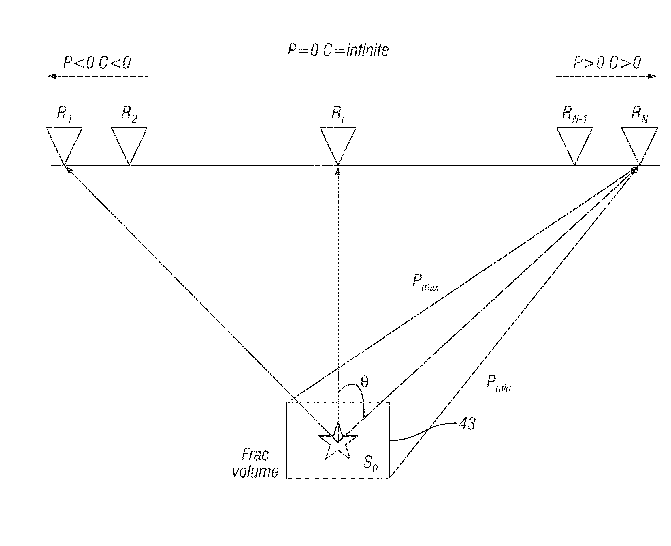
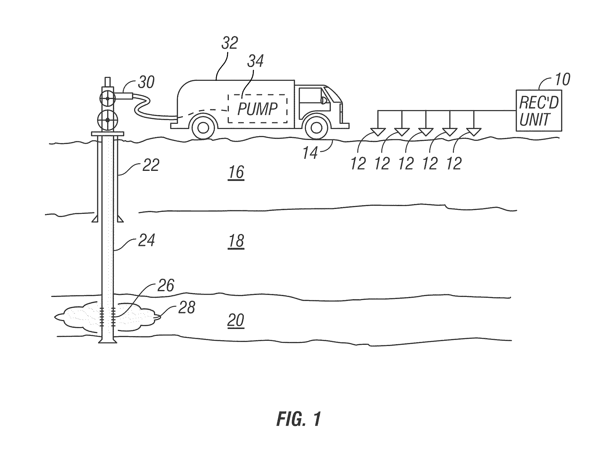
[0018]FIG. 1 shows a typical arrangement of seismic sensors as they would be used in one application of a method according to the invention. The example illustrated in FIG. 1 is associated with an application for passive seismic emission tomography known as “fracture monitoring.” It should be clearly understood that the application illustrated in FIG. 1 is only one possible application of a method according to the invention.

[0019]In FIG. 1, each of a plurality of seismic sensors, shown generally at 12, is deployed at a selected position proximate the Earth's surface 14. In marine applications, the seismic sensors would typically be deployed on the water bottom in a device known as an “ocean bottom cable.” The seismic sensors 12 in the present example may be geophones, but may also be accelerometers or any other sensing device known in the art that is responsive to velocity, acceleration or motion of the particles of the Earth proximate the sensor. The seismic sensors 12 generate ele...


PUM


Abstract

A method for seismic event mapping includes adaptively velocity filtering seismic signals recorded at selected positions. The velocity filtered signals are transformed into a domain of possible spatial positions of a source of seismic events. An origin in spatial position and time of at least one seismic event is determined from space and time distribution of at least one attribute of the transformed seismic data.

Description

CROSS-REFERENCE TO RELATED APPLICATIONS[0001]Not applicable.STATEMENT REGARDING FEDERALLY SPONSORED RESEARCH OR DEVELOPMENT[0002]Not applicable.BACKGROUND OF THE INVENTION[0003]1. Field of the Invention[0004]The invention relates generally to the field of seismic imaging of subsurface rock formations. More specifically, the invention relates to methods for determining hypocenters and focal mechanism of seismic events occurring in the Earth's subsurface.[0005]2. Background Art[0006]U.S. Patent Application Publication No. 2008 / 0068928 filed by Duncan et al. describes methods for determining the hypocenter (location of occurrence) of seismic events in the Earth's subsurface, and application of such methods to monitoring the progress of hydraulic fracturing operations. Such methods are generally known as “passive” seismic surveying because they do not use a separate, controllable seismic energy source to impart seismic energy into the subsurface, but use naturally occurring seismic even...

Claims


Application Information

Patent Timeline
Patent Type & Authority Patents(United States)
IPC IPC(8): G01V1/36
CPCG03B42/06G01V1/288
Inventor LIANG, CHUNTAOTHORNTON, MICHAEL P.MORTON, PETER
Owner MICROSEISMIC
Learn More