Navigation apparatus and navigation method

a navigation apparatus and navigation method technology, applied in navigation instruments, traffic control systems, instruments, etc., can solve problems such as difficulty in recognizing the displayed map and the locations, limited resolution or contrast of the display, and user may move forward in a wrong direction. or miss the essential facilities without being awar

Inactive Publication Date: 2013-11-19
KYOCERA CORP
View PDF30 Cites 2 Cited by
  • Summary
  • Abstract
  • Description
  • Claims
  • Application Information

AI Technical Summary

Benefits of technology

[0009]In accordance with this aspect, the facility information of the facility located in the neighborhood of the route from the point of departure to the point of destination is extracted from among the facility information included in the map information, and if at least one facility information is extracted, notification is given at a prescribed timing. Therefore, notification of the presence of a facility is given at a prescribed timing, so that the user can know the presence of a facility without watching a map. As a result, it is possible to provide a navigation apparatus capable of notifying the user that a facility is present in the neighborhood of the route to the destination.
[0011]In accordance with this aspect, visual notification of the presence of a facility is given at a prescribed timing, so that the user can visually know the presence of a facility. This prevents, for example, an influence on people around which would be given by voice notification.
[0022]In accordance with this aspect, an area defined based on the present location is displayed in the state in which the first casing and the second casing are open. Therefore, a map can be displayed by a simple operation of changing to the state in which the first casing and the second casing are open. On the other hand, display of the area defined based on the present location is stopped in the state in which the first casing and the second casing are closed, thereby reducing power consumption.
[0032]In accordance with this aspect, it is possible to provide a navigation method capable of notifying the user that a facility is present in the neighborhood of the route to the destination.

Problems solved by technology

A display on a mobile phone has a problem in that it is difficult to recognize the displayed map and the locations of essential facilities on the course of the route, because the display area is smaller than that of a display mounted on a car navigation apparatus and because the resolution or contrast of the display is limited.
Therefore, the user may move ahead to a wrong direction or may miss the essential facilities without being aware of their existence even if they are located in the user's proximity.
In particular, during the night when the environment is dark, it is difficult to check the map displayed on the display, because the backlight which illuminates the display turns off after a lapse of a prescribed time in order to reduce battery consumption.

Method used


Image

  • Navigation apparatus and navigation method
  • Navigation apparatus and navigation method
  • Navigation apparatus and navigation method

Examples


Embodiment Construction

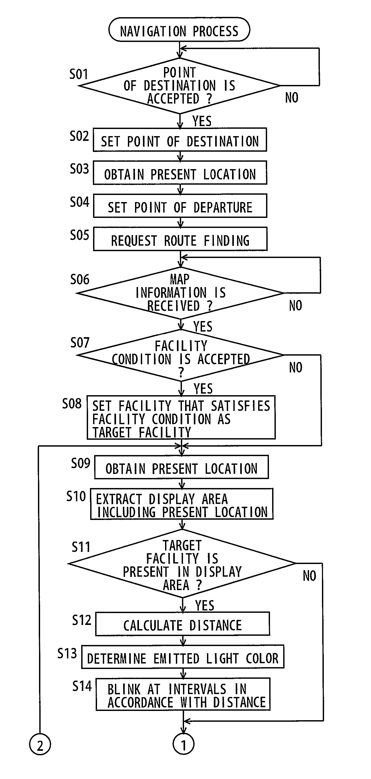
[0042]In the following, an embodiment of the present invention will be described with reference to the figures. In the following description, the same parts are denoted with the same reference numerals. Their names and functions are also the same. Therefore, a detailed description thereof will not be repeated.

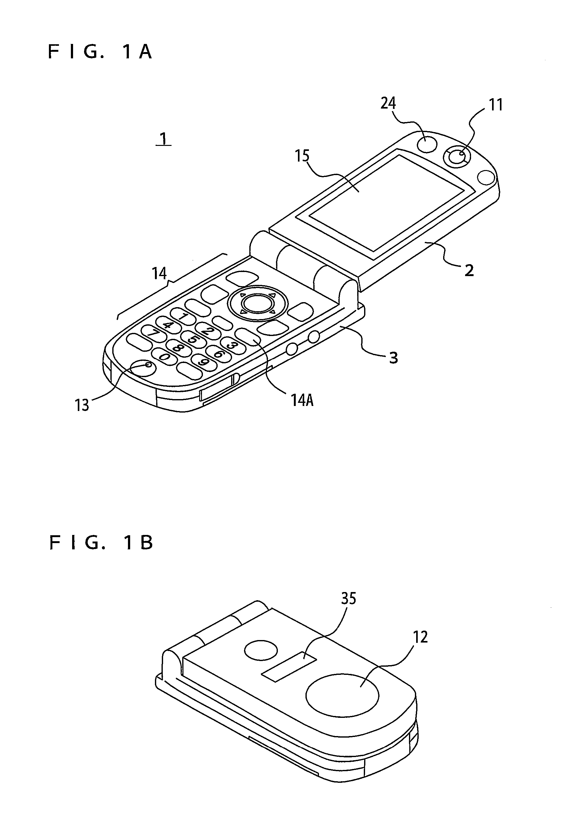
[0043]FIG. 1A and FIG. 1B are perspective views showing an external view of a mobile phone in an embodiment of the present invention. A mobile phone 1 is an example of the navigation apparatus. FIG. 1A shows an external view of a mobile phone in an open style and FIG. 1B shows an external view of a mobile phone in a closed style. Referring to FIG. 1A and FIG. 1B, mobile phone 1 includes an operation-side portion 3 and a display-side portion 2.

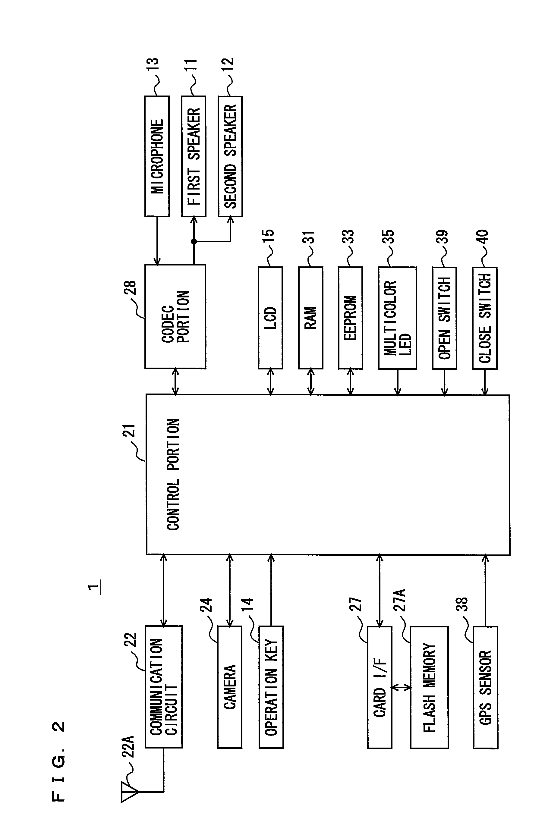
[0044]Operation-side portion 3 includes a power key 14A, operation key 14 including ten keys, a call key and the like, and a microphone 13 arranged on the inner surface thereof. Display-side portion 2 includes a liquid crystal display (LCD...


PUM


Abstract

In order to notify a user that a facility is present in the neighborhood of a route to a destination, a mobile phone includes a location obtaining portion to obtain a present location (S03, S09), a destination setting portion to set a point of destination (S02), a departure point setting portion to set a point of departure (S04), a facility extraction portion to extract facility information of a facility located in the neighborhood of a route from the point of departure to the destination from among facility information included in map information (S08), and a light emission control portion to give notification at a prescribed timing if at least one facility information is extracted by the facility extraction portion (S14).

Description

TECHNICAL FIELD[0001]The present invention relates to a navigation apparatus and a navigation method, and more particularly to a navigation method with a GPS function and a navigation method.BACKGROUND ART[0002]In recent years, mobile phones with a GPS (Global Positioning System) function have appeared, which communicate with a server to obtain service provided by the server to find a route from a point of departure to a destination. In use of such service, users visually check map information displayed on a display mounted on a mobile phone while moving from a point of departure to a point of destination and can reach the destination with assistance of voice guidance, if necessary.[0003]On the other hand, a map includes essential facilities such as convenience stores and gas stations, in addition to route information. Users often wish to drop in at desired facilities on the way to the destination using the navigation function of mobile phones. A technique of displaying a facility i...

Claims


Application Information

Patent Timeline
Patent Type & Authority Patents(United States)
IPC IPC(8): G01C21/34G01C21/00G06Q30/02G06Q30/06G06Q50/00G08G1/005G09B29/00G09B29/10H04W4/02H04W4/024
CPCG01C21/20G01C21/3635G01C21/3647G01S19/39G08G1/096827G08G1/096838G08G1/096866G08G1/096883G09B29/106H04W4/02H04W4/023H04W4/024
Inventor KATO, TAKAYUKIHONDA, HIROAKI
Owner KYOCERA CORP
Why Eureka
Try Eureka