Interactive geo-referenced source imagery viewing system and method

a georeferenced source and imagery technology, applied in the field of image mapping systems and methods, can solve problems such as loss of context or introduction of artifacts, and achieve the effect of smooth transition

Active Publication Date: 2015-05-05
GOOGLE LLC
View PDF60 Cites 15 Cited by
  • Summary
  • Abstract
  • Description
  • Claims
  • Application Information

AI Technical Summary

Benefits of technology

[0006]Systems and methods provide a robust architecture to smoothly transition between different images and create the illusion of true three dimensional motion.
[0011]In accordance with a further embodiment, a method of processing geographical imagery comprises issuing a request for images, the request including a target location; receiving a plurality of unstitched oblique images in response to the request; selecting one of the plurality of unstitched oblique images; and displaying the selected unstitched oblique image in conjunction with other imagery on a display so that the selected unstitched oblique image smoothly transitions to or from the other imagery on the display.

Problems solved by technology

However, as different images are taken from different locations and orientations, there may be a loss of context or the introduction of artifacts when changing views.

Method used


Image

  • Interactive geo-referenced source imagery viewing system and method
  • Interactive geo-referenced source imagery viewing system and method
  • Interactive geo-referenced source imagery viewing system and method

Examples


Embodiment Construction

[0025]The aspects, features and advantages of the present invention will be appreciated when considered with reference to the following description of various embodiments and accompanying figures. The same reference numbers in different drawings may identify the same or similar elements. The features of all embodiments, unless expressly stated to the contrary, may be used with any other feature of other embodiments. Furthermore, the following description does not limit the present invention; rather, the scope of the invention is defined by the appended claims and equivalents.

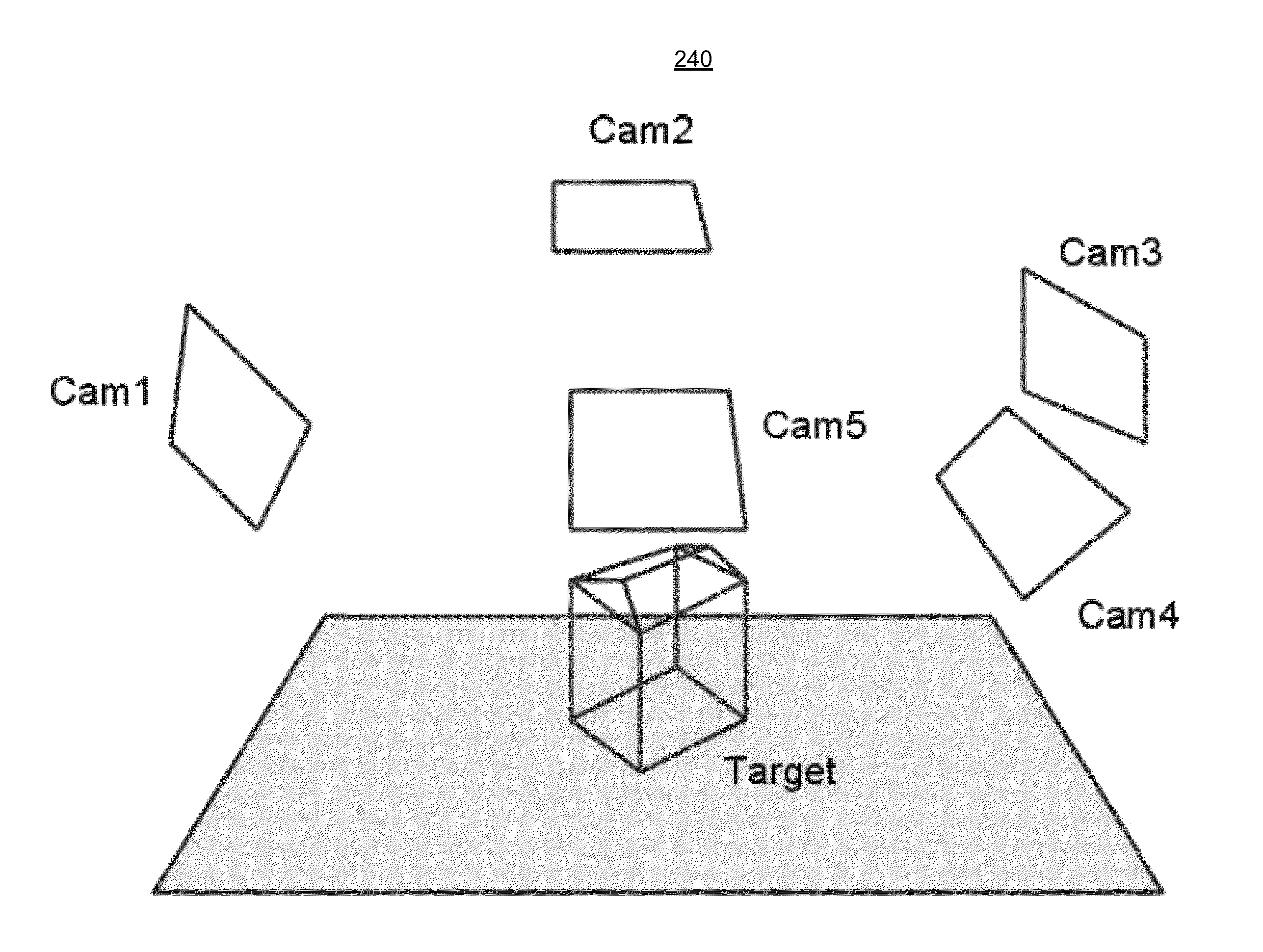
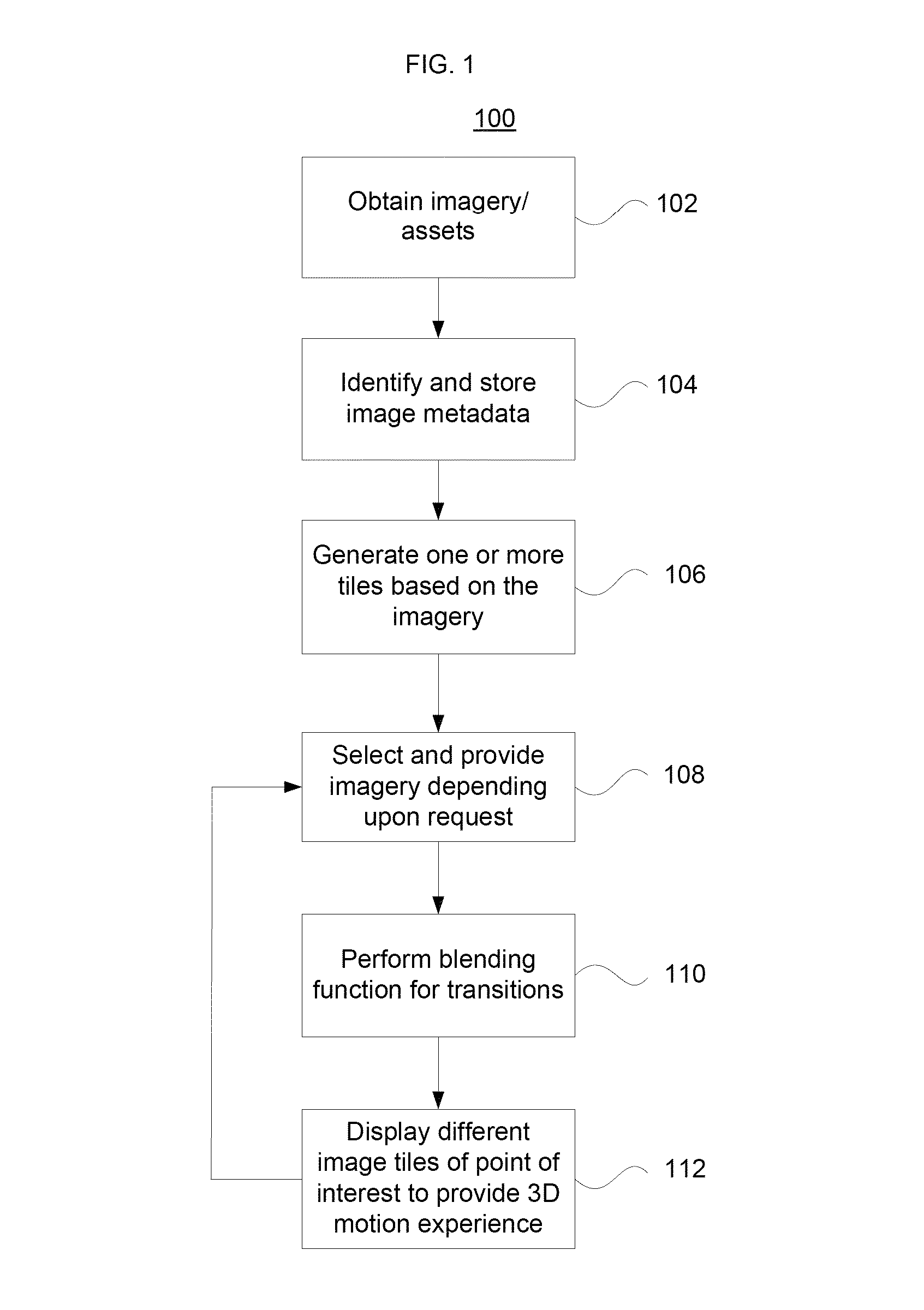
[0026]In accordance with aspects of the present invention, images having different viewpoints about a target location are integrated to provide the experience of three dimensional motion. FIG. 1 illustrates an exemplary process 100 for obtaining and handling images associated with a target location. Source images are desirably processed upon acquisition. Imagery stored in a database may be selected and provided ...


PUM


Abstract

The present invention pertains to geographical image applications. A user may transition between nadir and street level imagery using unstitched oblique imagery. Oblique images offer a rich set of views of a target location and provide a smooth transition to or from other images such as nadir photographs taken by satellites or street level photographs taken by ground level users. Using unstitched oblique images avoids artifacts that may be introduced when stitching together one or more images. This allows an application to display images to a user and create the illusion of three dimensional motion.

Description

BACKGROUND OF THE INVENTION[0001]1. Field of the Invention[0002]The present invention relates generally to image mapping systems and methods. More particularly, the present invention relates to using oblique imagery and providing smooth transitions between different images to create a three dimensional motion experience for a viewer.[0003]2. Description of Related Art[0004]Imagery taken by satellites, planes and other sources is used to provide visual information about the earth and different points of interest. Recently, improvements in computer processing power and broadband streaming technology have lead to the development of interactive systems for navigating imagery. Some interactive map navigation systems provide a user interface (“UI”) with navigation controls for dynamically navigating cities, neighborhoods and other terrain in three dimensions. The navigation controls enable users to tilt, pan, rotate, zoom and activate terrain and buildings for different perspectives at a ...

Claims


Application Information

Patent Timeline
Patent Type & Authority Patents(United States)
IPC IPC(8): G06K9/00
CPCG09G5/38G06K9/00624G06F16/29G06T11/60G06T17/05G09G5/377G09G2340/12
Inventor REINHARDT, TILMANLAFON, STEPHANESZYBALSKI, ANDREW
Owner GOOGLE LLC
Why Eureka
Try Eureka