Navigation device and method

a navigation device and navigation method technology, applied in the direction of navigation instruments, instruments, wave based measurement systems, etc., can solve the problems of particular problems, inability to trust position information, delay in pnd carrying out/being enabled to carry out specified functions, etc., to avoid needless processing and reduce the effect of

Active Publication Date: 2015-06-23
TOMTOM NAVIGATION BV
View PDF21 Cites 0 Cited by
  • Summary
  • Abstract
  • Description
  • Claims
  • Application Information

AI Technical Summary

Benefits of technology

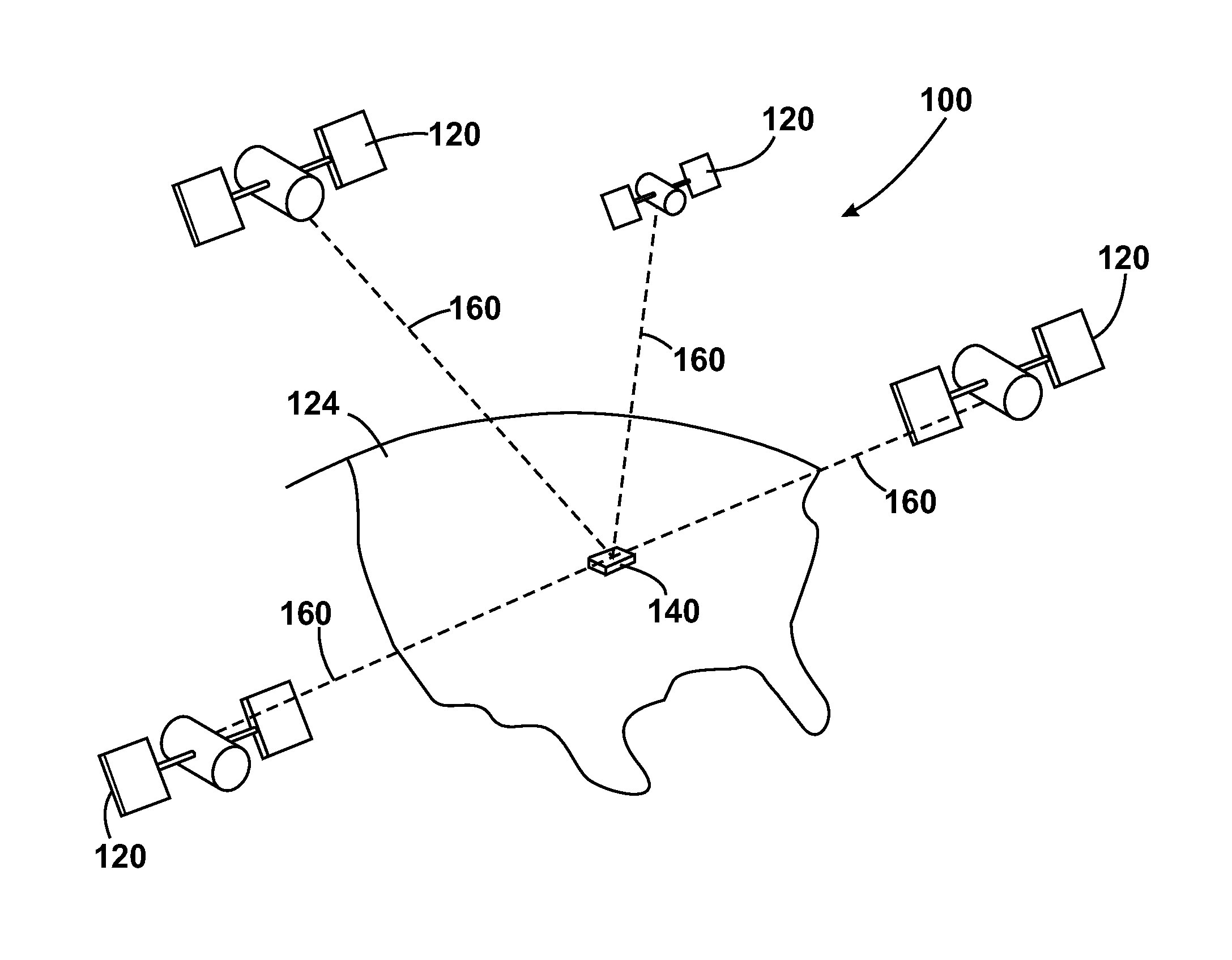
[0032]The invention of the first aspect is advantageous as the time zone information can be used to identify an area in a country in which the navigation device is located, the seed position being a location in that area. Furthermore, the time zone information is selectively used, for example, dependent on whether the country in which the navigation device is located extends across more than one time zone. In this way, the time zone information is only used when further information above and beyond the country is required in order to determine a seed position from which the visible satellites can be determined, avoiding needless processing.
[0033]Once an approximate location of the navigation device has been identified, a search for GNSS satellites can be made without having to start from scratch. In particular, the navigation device may have a memory having stored therein map information on the visible GNSS satellites at each possible seed location and the processing device may be arranged (for example, by suitable programming) to use the map information to determine a seed position from the information on the country and time zone in which the navigation device is located. The processing device may be further arranged to determine the visible satellites from the seed position. Carrying out a search for satellites based on a list of visible satellites may reduce the TTFF.
[0038]The invention of the second aspect is advantageous as the information on the identity of the wireless network(s), for example cellular network(s), from which the wireless device can receive broadcast signals, such as control signals (e.g. BCCH) of a cellular network, can be used to identify an area in which the navigation device is located, the seed position being a location in that area. Once an approximate location of the navigation device has been identified, a search for GNSS satellites can be made without having to start from scratch. In particular, the navigation device may have a memory having stored therein map information on the visible GNSS satellites at each possible seed location and the processing device may be arranged (for example, by suitable programming) to use the map information to determine a seed position from the identity of the wireless network(s) from which the wireless receiver can receive broadcast signals. The processing device may be further arranged to determine the visible satellites from the seed position. Carrying out a search for satellites based on a list of visible satellites may reduce the TTFF.
[0043]The invention of the third aspect is advantageous as the location information input by the user can be used to identify an area in which the navigation device is located, the seed position being a location in that area. Once an approximate location of the navigation device has been identified, a search for GNSS satellites can be made without having to start from scratch. In particular, the navigation device may have a memory having stored therein map information on the visible GNSS satellites at each possible seed location and the processing device may be arranged (for example, by suitable programming) to use the map information to determine a seed position from the user input. The processing device may be further arranged to determine the visible satellites from the seed position. Carrying out a search for satellites based on a list of visible satellites may reduce the TTFF.
[0053]The invention has the advantage in that the time zone information or / and the identify of the wireless network(s) (network coverage information) can be used to identify an approximate location of the navigation device such that, in a far start scenario, the navigation device can quickly identify GNSS satellites that should be visible at the location of the navigation device. In this way, the TTFF may be greatly reduced without significantly increasing power consumption. Furthermore, it may be possible to implement the invention on current navigation devices through a software and / or firmware upgrade. Yet another advantage is that the information required can be obtained from the broadcast signals (e.g. BCCH. P-CCPCH, Synchronisation channel (SynchCh)) broadcast by base stations of wireless networks and therefore, there are no call costs (in particular roaming call costs) for obtaining this information. The navigation device may be implemented without the requirement of a Subscriber Identity Module (SIM). Yet a further advantage is that the broadcast signals can be decoded very quickly resulting in little delay to the initiation of a satellite search based on information provided in the broadcast signal.

Problems solved by technology

Delays in obtaining a position fix will result in delays in the PND carrying out / being enabled to carry out the specified functionality, such as determine a navigable route.
This problem is particular pronounced when the PND has been switched off and relocated by a great distance before being switched back on (far start), for example, if a user takes the PND with him / her on a long haul flight or during delivery of the PND to a customer.
However, if the PND has been moved a significant distance away from the position it was in when it was turned off, the position information cannot be trusted.
Such a search can take significant time.
However, a receiver having such a high number of channels has increased hardware complexity and power consumption (a rule of thumb is that one channel consumes 1-2 mA during satellite acquisition).
Greater hardware complexity will result in greater cost for the GPS receiver.
Furthermore, to implement such a solution in known GNSS receivers equipped with 12 to 16 channels requires modification of the hardware (through design and tapeout of a new chip) and cannot be achieved through software / firmware upgrades.
Use of MCC can result in a reduction in the TTFF during a far start for most countries, but in some countries with large territories (e.g Russian Federation, United States of America, Canada, People's Republic of China and Republic of Chile) the use of MCC is less effective or may even result in an increase in the TTFF.
The drawback of such a technique is that for far start scenarios, the mobile telephone or other cellular device used by the GNSS receiver is likely to be in roaming mode (operating within the cellular network (a visited network) in which the cellular device was not originally registered) and therefore, the downloading of the information is likely to incur significant cost.

Method used


Image

  • Navigation device and method
  • Navigation device and method
  • Navigation device and method

Examples


Embodiment Construction

[0092]Preferred embodiments of the present invention will now be described with particular reference to a PND. It should be noted, however, that the teachings of the present invention are not limited to PNDs but are universally applicable to any type of processing device that is configured to provide position information using a Global Navigation Satellite System (GNSS). It follows therefore that in the context of the present application, a navigation device is intended to include (without limitation) navigation devices, irrespective of whether that device is embodied as a PND, a navigation device built into a vehicle, or indeed a computing resource (such as a desktop or portable personal computer (PC), mobile telephone or portable digital assistant (PDA)) executing route planning and navigation software.

[0093]With the above provisos in mind, FIG. 1 illustrates an example view of Global Navigation Satellite System (GNSS) 100, usable by navigation devices 140. In general, GNSS is a s...


PUM


Abstract

A navigation device includes a global navigation satellite system (GNSS) receiver for receiving GNSS signals broadcast by satellites of a GNSS, a receiver for receiving location information input by a user, time information and / or wireless network coverage information and a processing device. In at least one embodiment, the processing device is arranged to determine a seed position from the location information input by a user; time information and / or wireless network coverage information and controls the GNSS receiver to acquire GNSS satellites based on the determined seed position.

Description

FIELD OF THE INVENTION[0001]This invention relates to navigation devices and to methods for navigation devices. Illustrative embodiments of the invention relate to portable navigation devices (so-called PNDs), in particular PNDs that include Global Navigation Satellite System (GNSS) signal reception and processing functionality. Other embodiments relate, more generally, to any type of processing device that is configured to execute navigation software so as to provide route planning, and preferably also navigation, functionality.BACKGROUND TO THE INVENTION[0002]Portable navigation devices (PNDs) that include GNSS signal reception and processing functionality are well known and are widely employed as in-car or other vehicle navigation systems.[0003]In general terms, a modern PNDs comprises a processor, memory (at least one of volatile and non-volatile, and commonly both), and map data stored within said memory. The processor and memory cooperate to provide an execution environment in...

Claims


Application Information

Patent Timeline
Patent Type & Authority Patents(United States)
IPC IPC(8): G01C21/00G01S19/25H04H20/74
CPCG01S19/252G01C21/26G01S19/05
Inventor LAI, YING-LIN
Owner TOMTOM NAVIGATION BV
Why Eureka
Try Eureka