System for post processing GNSS/INS measurement data and camera image data

a technology of measurement data and camera image data, applied in surveying and navigation, navigation instruments, instruments, etc., can solve the problems of insufficient reliability of solutions, system and method etc., to save time and processing resources, perform more time-consuming and processing intensive processing operations, and high accuracy of location information

Active Publication Date: 2015-11-10
NOVATEL INC
View PDF10 Cites 1 Cited by
  • Summary
  • Abstract
  • Description
  • Claims
  • Application Information

AI Technical Summary

Benefits of technology

[0007]The invention is an improved navigation mapping system for performing post processing of GNSS and INS measurement data and image data to provide highly accurate location information for a camera, an INS measurement unit or both. The system and method performs first processing operations using the GNSS and INS measurement data, to determine sets of position, velocity and attitude solutions. The system then analyzes the sets of solutions to determine which measurement data provide sufficiently reliable solutions from which to determine the precise position, velocity and attitude of the camera, and which measurement data do not provide sufficiently reliable solutions. The system and method then performs more time consuming and processing intensive processing operations using the measurement data and the corresponding image data that are associated with solutions that are not sufficiently reliable. The improved system and method thus saves time and processing resources by selectively performing the more complex, time consuming and processor-intensive processing operations, without adversely affecting the precision of the camera location information.

Problems solved by technology

The system then analyzes the sets of solutions to determine which measurement data provide sufficiently reliable solutions from which to determine the precise position, velocity and attitude of the camera, and which measurement data do not provide sufficiently reliable solutions.
The system and method then performs more time consuming and processing intensive processing operations using the measurement data and the corresponding image data that are associated with solutions that are not sufficiently reliable.

Method used


Image

  • System for post processing GNSS/INS measurement data and camera image data
  • System for post processing GNSS/INS measurement data and camera image data
  • System for post processing GNSS/INS measurement data and camera image data

Examples


Embodiment Construction

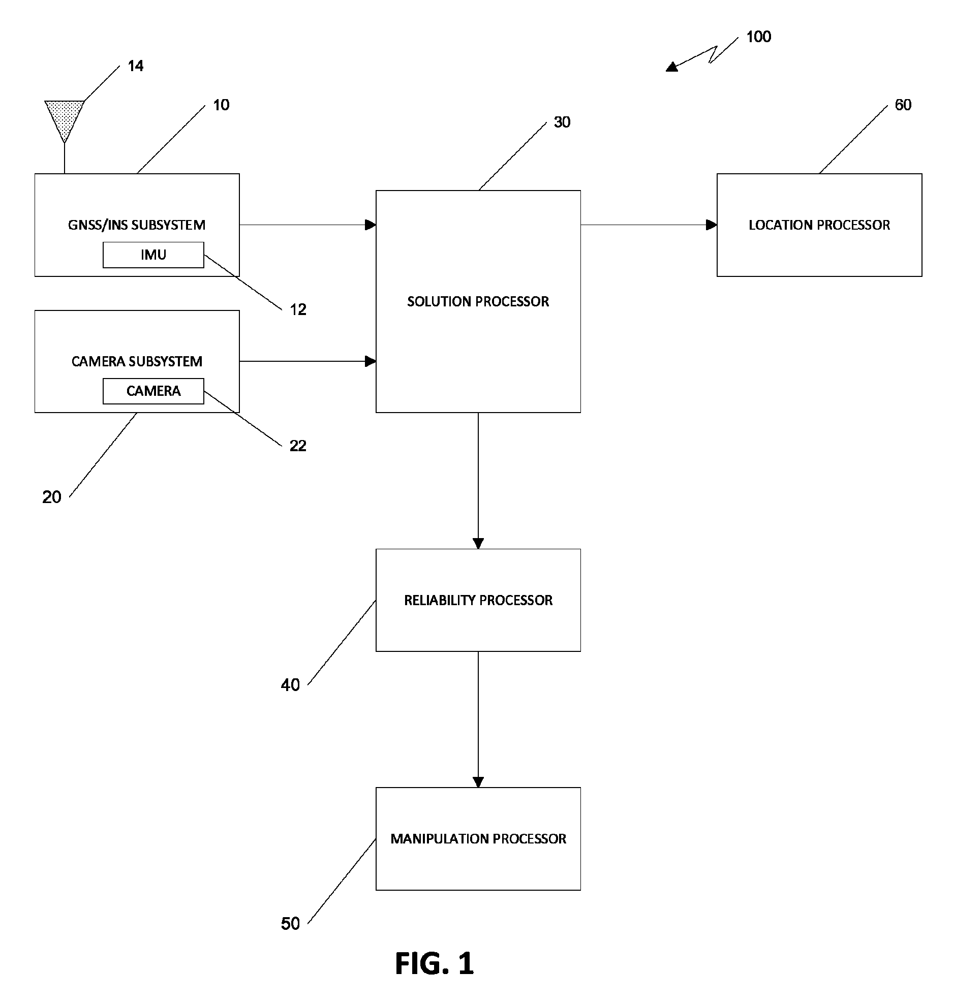
[0012]Referring to FIG. 1, a navigation mapping system 100 includes a GNSS / INS subsystem 10 with a GNSS antenna 14 and an INS measurement unit 12, and a camera subsystem 20 that includes a camera 22 with known characteristics and which is in a known location relative to the GNSS antenna 14 and / or the INS measurement unit 12. The GNSS / INS subsystem 10 and camera subsystem 20 provide GNSS / INS measurement data and image data, respectively, to a position, velocity and attitude solution processor 30. The data is time tagged in GNSS time by the respective subsystems or alternatively by the processor.

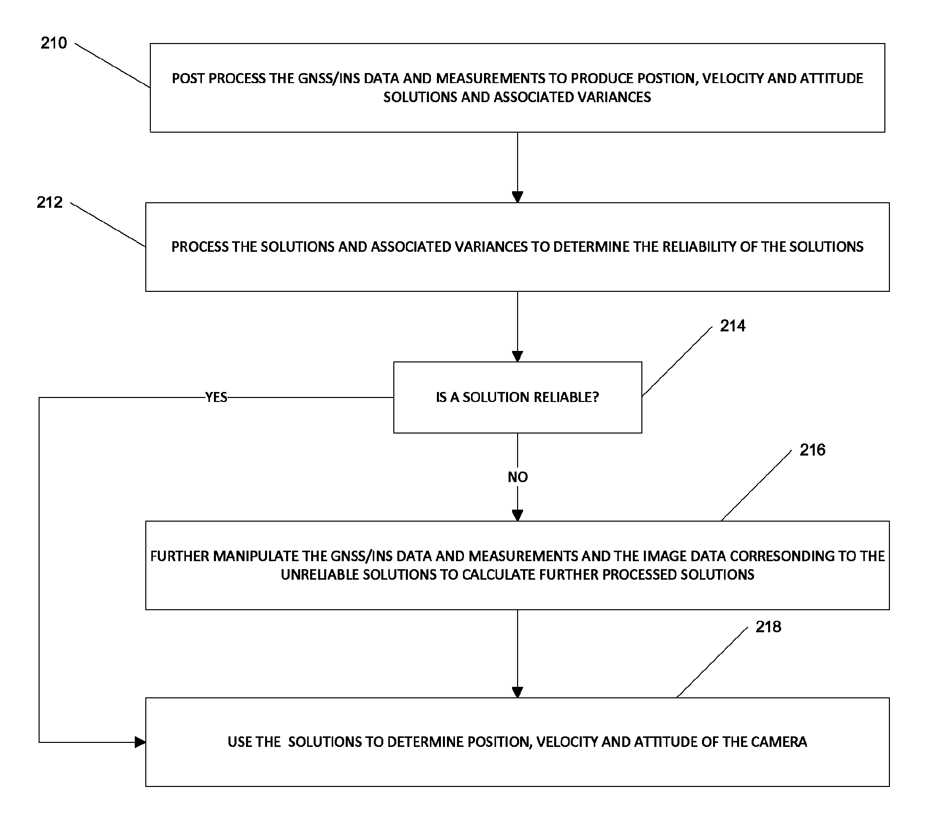
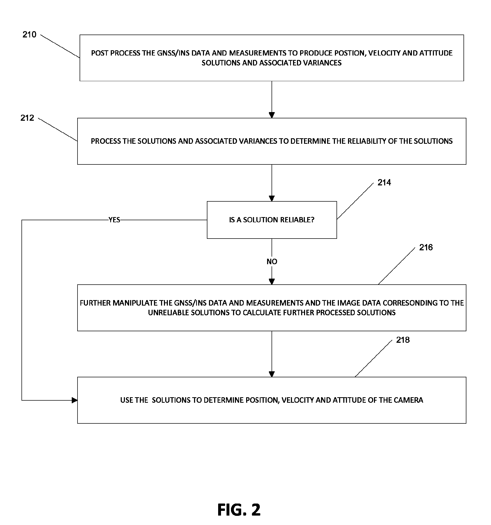
[0013]The processor 30 performs first processing operations in a known manner using the measurement data provided by the GNSS / INS subsystem to calculate sets of position, velocity and attitude solutions that correspond in time to the respective camera images. As discussed in more detail below, a reliability processor 40 analyses the sets of position, velocity and attitude solutions to determin...


PUM


Abstract

A system for performing post processing of GNSS and INS measurement data and image data to provide highly accurate location information for a camera, an INS measurement unit or both performs first processing operations using the GNSS and INS measurement data, to determine position, velocity and attitude solutions. The system then analyzes the solutions to determine which measurement data provide sufficiently reliable solutions from which to determine the precise position, velocity and attitude of the camera, and thus, which measurement data do not provide sufficiently reliable solutions. The system and method then performs more time consuming and processing intensive processing operations using the measurement data and camera image data that are associated with solutions that are not sufficiently reliable.

Description

BACKGROUND OF THE INVENTION[0001]1. Field of the Invention[0002]The invention relates generally to navigation mapping systems and, more particularly, to navigation mapping systems that post process GNSS / INS measurement data and camera image data.[0003]2. Background Information[0004]Many navigation mapping systems utilize position, velocity and attitude solutions that correspond to still or video camera images to provide location and other information of interest to users. GIS systems, for example, which provide users with the critical information such as the locations of building entrances, fire hydrants, area trees, and so forth, may rely on photographic or video images of the area and use corresponding GNSS and INS measurement data to determine the locations of the respective features of interest. Route mapping systems, such as systems for providing driving directions, may provide users with images of the end destination, intersections and other points of interest along the route,...

Claims


Application Information

Patent Timeline
Patent Type & Authority Patents(United States)
IPC IPC(8): G01C21/16G01S19/13
CPCG01C21/165G01S19/13G01S19/14G01S19/39G01S19/49G01S19/52G01S19/40G01S19/485G01S19/396G01C21/1656
Inventor ROESLER, GREGORY J.
Owner NOVATEL INC
Why Eureka
Try Eureka