Robot path planning method based on data fusion of single-line lidar and binocular camera

A technology of single-line laser radar and binocular camera, which is applied to instruments, surveying and navigation, road network navigators, etc., can solve the problems of high price and inapplicability of 3D laser radar, and achieve good real-time performance, low power consumption, and method simple effect

Inactive Publication Date: 2019-10-22
马鞍山天邦开物智能商务管理有限公司 +1
View PDF0 Cites 29 Cited by
  • Summary
  • Abstract
  • Description
  • Claims
  • Application Information

AI Technical Summary

Problems solved by technology

[0008] Aiming at the problem that traditional 3D laser radar and binocular camera fusion are used for robot path planning, the price of 3D laser radar is too high and it is not applicable in many occasions. The present invention provides a robot path based on data fusion of single-line laser radar and binocular camera. Planning method; the present invention adopts a calibration method, fits an error function, performs error correction on the point cloud of binocular vision, and then projects the point cloud to obtain the used point cloud projection, thereby completing the path planning of the mobile robot

Method used


Image

  • Robot path planning method based on data fusion of single-line lidar and binocular camera
  • Robot path planning method based on data fusion of single-line lidar and binocular camera
  • Robot path planning method based on data fusion of single-line lidar and binocular camera

Examples


Embodiment 1

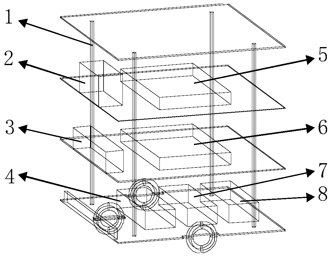
[0038] combine figure 1 , in order to realize a robot path planning method based on single-line laser radar and binocular camera data fusion in this embodiment, a robot equipped with 2D laser radar and binocular camera is designed. Built as a whole, the 2D laser radar 2 and the binocular camera 3 are placed on the central axis of the mobile robot. The robot is equipped with HCR robot platform 4, bottom motion controller 5, development board 6 (JETSON TX2 development board), main controller 7 and wireless network card 8 at the same time.

[0039] In this embodiment, the mobile robot uses 2D laser radar and binocular camera fusion on the basis of SLAM to complete the construction of accurate dense point cloud, thereby completing the path planning of the mobile robot.

[0040] The SLAM algorithm is the basis of this embodiment. Accurate SLAM dense point cloud construction plays an important role in the later data fusion. However, this embodiment uses binocular vision SLAM, so th...


PUM


Abstract

The invention discloses a robot path planning method based on the data fusion of a single-line lidar and a binocular camera, belonging to the technical field of robot navigation positioning, map construction and scientific research. According to the invention, the precise dense point cloud construction is completed based on an SLAM through the fusion of a 2D lidar and the binocular camera, and therefore, the path planning of a mobile robot is completed. The robot path planning method has the advantages of dense point cloud, good real-time performance, simple method, low cost, low power consumption and good real-time performance, an obstacle in a working environment can be detected in real time and the precise positioning of the robot is completed, and therefore, the path planning of the mobile robot is complete.

Description

technical field [0001] The invention belongs to the technical fields of robot navigation and positioning, map construction and scientific research, and more specifically relates to a robot path planning method based on fusion of single-line laser radar and binocular camera data. Background technique [0002] With the development of robot technology, robots are no longer traditional robots that can only execute instructions mechanically. Robots are developing in the direction of intelligence, diversification and popularization. Intelligent robots use cutting-edge multidisciplinary research theories and achievements. Since the beginning of the new century, robot technology has been rapidly improved. Because of their high efficiency, accuracy, and practicality, they have been widely used in industrial production and military fields. In various industries, robotics is the embodiment of a country's scientific and technological strength. Artificial intelligence represented by robo...

Claims


Application Information

Patent Timeline
Patent Type & Authority Applications(China)
IPC IPC(8): G01C21/34
CPCG01C21/3446
Inventor 吕成军吴玉秀王路邵伟伟
Owner 马鞍山天邦开物智能商务管理有限公司
Why Eureka
Try Eureka