Methods and systems for facilitating online collaboration and distribution of geospatial data

a geospatial data and online collaboration technology, applied in the field of geospatial data communication, can solve the problems of large amount of bandwidth, insufficient flexibility and efficiency of existing data communication methods and systems, and insufficient efficiency of communicating and exchanging certain types of data, etc., to achieve the effect of facilitating online collaboration and distribution

Active Publication Date: 2016-05-17
LEIDOS
View PDF14 Cites 13 Cited by
  • Summary
  • Abstract
  • Description
  • Claims
  • Application Information

AI Technical Summary

Benefits of technology

[0010]Various aspects of the present invention, roughly described, provide improved methods, systems, and software for facilitating online collaboration and distribution of geospatial data. In various embodiments, geospatial data available over a network can be updat

Problems solved by technology

Unfortunately, existing data communication methods and systems often fail to provide sufficient flexibility and efficiency for communicating and exchanging certain types of data.
Notably, existing data systems and related methods do not always efficiently manage the communication of geospatial data.
Due to the large amounts of geospatial data required to perform meaningful analysis, the communication of such data over networks can consume large amounts of bandwidth, thereby reducing the efficiency of such communication.
Nevertheless, existing methods and systems for providing geospatial data do not always provide such updated data in an efficient manner.
It c

Method used


Image

  • Methods and systems for facilitating online collaboration and distribution of geospatial data
  • Methods and systems for facilitating online collaboration and distribution of geospatial data
  • Methods and systems for facilitating online collaboration and distribution of geospatial data

Examples


Embodiment Construction

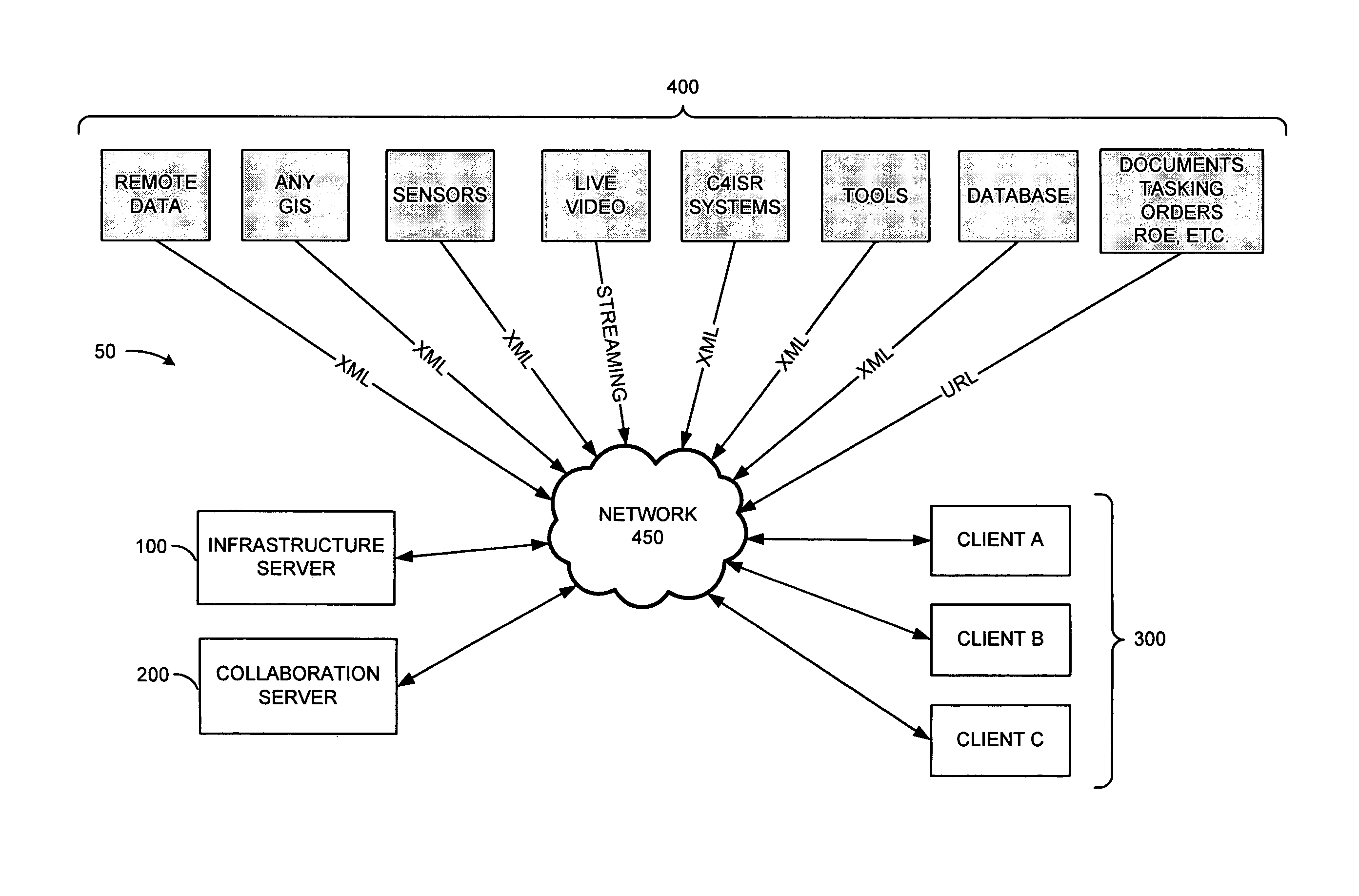
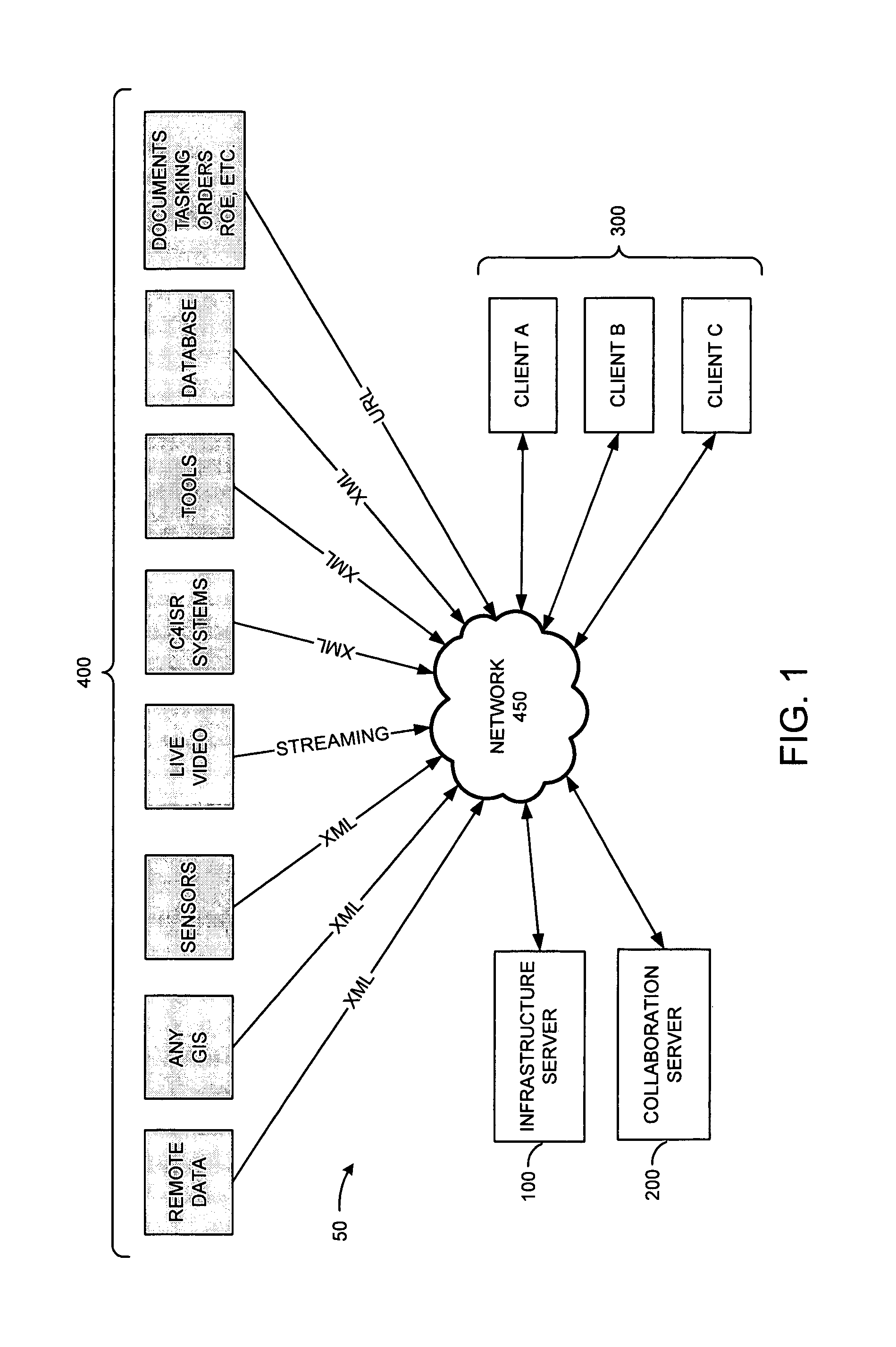
[0024]FIG. 1 illustrates a block diagram of a system 50 for distributing geospatial data in accordance with an embodiment of the present invention. Geospatial data can take many forms, including but not limited to: (1) mathematical descriptions of the world (i.e. WGS84); (2) imagery and maps that add visual value to the earth; (3) vector overlays describing fixed things on earth (i.e. natural and manmade structures); (4) dynamic objects that change in a temporal manner (i.e. movement, sensors, etc.); and (5) other data. As such, it will be appreciated that geospatial data as described herein can refer to any data representation of geographic data.

[0025]System 50 provides hardware and software for network communication of geospatial data between the various components of the system 50. By interfacing with system 50 through one or more lightweight, easily deployable clients 300, users of the clients 300 can be permitted to view and interact with geospatial data, and also collaborate w...


PUM


Abstract

Improved methods, systems, and software for facilitating online collaboration and distribution of geospatial data are provided. Geospatial data available over a network can be updated in real-time and provided to one or more clients. User-accessible views of the geospatial data can be dynamically built by the clients and presented to users of the clients. Various methods of online collaboration between users of the clients can also be supported. The geospatial data can be provided in an XML format, thereby providing for efficient communication of data over the network. In various embodiments, the geospatial data can be an annotation prepared by a user of a second client, thereby allowing the user of the second client to collaborate with a user of the first client. Functionality can also be provided for converting geospatial data between flat and spherical formats.

Description

CROSS-REFERENCE TO RELATED APPLICATIONS[0001]This application relates to and claims the benefit of U.S. Provisional Application No. 60 / 540,460 filed Jan. 30, 2004 and entitled Method and System for Providing Geospatial Collaboration, which is incorporated by reference herein.BACKGROUND OF THE INVENTION[0002]1. Field of the Invention[0003]The present invention is directed to technology for facilitating communication of geospatial data.[0004]2. Description of the Related Art[0005]In recent years, the proliferation of networked computing systems and the Internet has greatly expanded the methods in which users can communicate with each other. Such technology has improved the ability of users to transfer information and data through increasingly convenient ways.[0006]Unfortunately, existing data communication methods and systems often fail to provide sufficient flexibility and efficiency for communicating and exchanging certain types of data. Notably, existing data systems and related me...

Claims


Application Information

Patent Timeline
IPC IPC(8): G06F15/16H04L29/06
CPCH04L65/4015H04L67/02H04L67/52
Inventor ABUZALAF, SAMSUTTLE, CARLREINBACHS, NAMEJS
Owner LEIDOS
Why Eureka
Try Eureka