Method of modelling buildings on the basis of a georeferenced image

a georeferenced image and building technology, applied in the field of real objects, can solve the problems of increasing modelling costs, irksome and expensive, and affecting the accuracy of the model, and achieve the effect of precise representation

Active Publication Date: 2016-07-19
THALES SA
View PDF27 Cites 8 Cited by
  • Summary
  • Abstract
  • Description
  • Claims
  • Application Information

AI Technical Summary

Benefits of technology

[0025]The modelling method according to the invention makes it possible to jointly determine all the descriptive parameters of the object in a reasonable time, by virtue in particular of the combination between the application of an optimization scheme on the basis of a suite of parameters chosen from among a plurality of suites of parameters initialized for example randomly. Thus, the method according to the invention utilizes a double iteration, the first iteration fixing an initial suite of parameters used as starting point by the optimization scheme, which participates in a second iteration to determine the optimal local suite of parameters as quickly as possible.
[0048]Comparison between images is avoided, thereby making it possible notably to avoid the snag of comparisons between images of different natures, which comparisons are doomed to failure.

Problems solved by technology

As a general rule, this input makes it possible to obtain models of good quality on optical images, but it turns out to be irksome and expensive.
Moreover, certain types of images such as images of SAR type (the acronym standing for “Synthetic Aperture Radar”) are very difficult for a human operator to interpret, which complicates the input of buildings, requires operators trained specifically for this type of image, and consequently increases the modelling costs.
However, this scheme comprises several limits.
On the one hand, it makes it possible to determine only the height of a building, and does not therefore solve the problem of determining its footprint.
Moreover, it operates only with optical images, and does not therefore allow extraction on the basis of images of SAR type.
However, these techniques are prone to numerous errors, notably because of the imperfections in the detections of contours.
Furthermore, a suite of parameters culminating in results that are satisfactory for a given image may turn out to be totally unsuited to other images; this problem is further heightened for images of SAR type.
Consequently, these algorithms based on segmentation lack robustness.
This scheme does not make it possible to automatically determine all the parameters characterizing a building in the image, but only a single parameter (the height) on the basis of a first model already extracted beforehand.

Method used


Image

  • Method of modelling buildings on the basis of a georeferenced image
  • Method of modelling buildings on the basis of a georeferenced image
  • Method of modelling buildings on the basis of a georeferenced image

Examples


Embodiment Construction

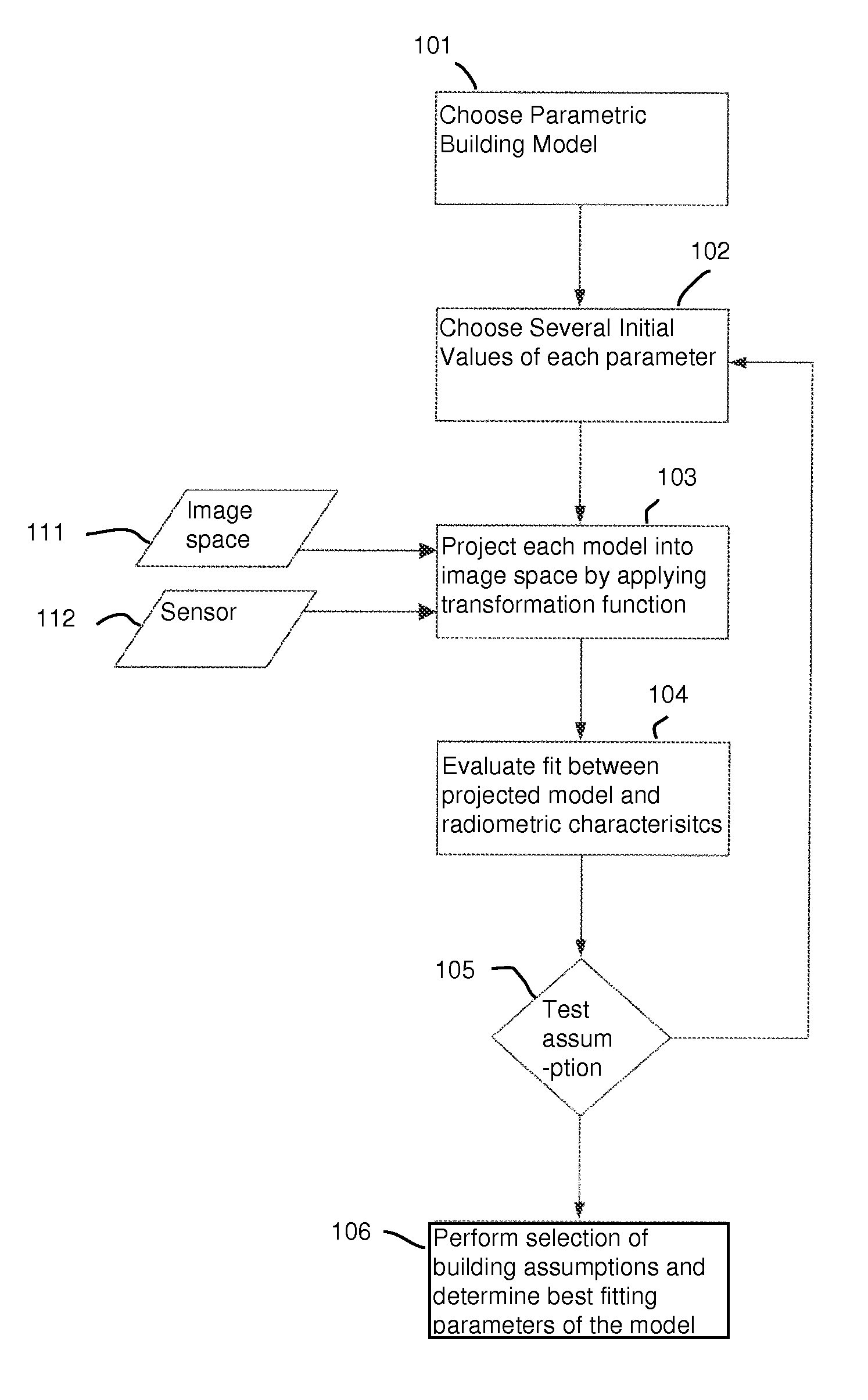
[0066]The examples presented subsequently are applied to the modelling of buildings, but the method according to the invention may be applied to the modelling of any real object whose dimensions are significant enough to appear on the image.

[0067]FIG. 1 illustrates the steps of a first implementation of the modelling method according to the invention. The method is executed on a georeferenced image emanating from a sensor onboard an aircraft or a satellite. The picture-capture model of the georeferenced image may be represented by a parametrized function, denoted fθ1, . . . , θn(X,Y,Z), matching up a 3D coordinate of the terrain space with a corresponding 2D coordinate on the image:

f(θ, . . . ,θn)(Xterrain,Yterrain,Zterrain)=(columnimage,rowimage)

where the parameters θ1, . . . , θn depend on the physical characteristics of the sensor.

[0068]The method may be executed only if the image is not orthorectified, stated otherwise, if the function f satisfies that

[0069]∂f(θ,⁢…⁢,θn)∂Z

[0070]i...


PUM


Abstract

A method of modelling real objects represented in an image of the terrestrial surface, in particular buildings, on the basis of a geographically referenced image, the image being produced by an aerial or space sensor associated with a physical picture-capture model, comprises at least the following steps: choosing a parametric model of the external surface of the said real object; for several suites of parameters of the said model: projecting the parametrized model into the image by applying the physical picture-capture model, and evaluating the fit between the projected model and the radiometric characteristics of the image; and determining the parameters of the model for which the fit is the best so as to model the said object with these parameters. The method of modelling applies notably to teledetection, digital geography, to the construction of urban 3D databases or their updating.

Description

CROSS-REFERENCE TO RELATED APPLICATIONS[0001]This application claims priority to foreign French patent application No. FR 1102288, filed on Jul. 22, 2011, and foreign French patent application No. FR 1102289, filed on Jul. 22, 2011, the disclosures of which are incorporated by reference in their entireties.FIELD OF THE INVENTION[0002]The present invention relates to a method of modelling real objects, in particular buildings, on the basis of a geographically referenced image. It applies notably to teledetection, digital geography, to the construction of urban 3D databases or their updating.BACKGROUND[0003]The devising of a 3D database for modelling an urban zone generally involves a phase of manual or automatic extraction of the framework on the basis of one or more aerial or space images of the zone to be modelled. The images used for this modelling can emanate from diverse observation sensors: a conventional photographic apparatus, an image sensor onboard an aircraft or an observa...

Claims


Application Information

Patent Timeline
Patent Type & Authority Patents(United States)
IPC IPC(8): G06T7/00G06T17/00G06K9/00G06T17/05
CPCG06T17/00G06K9/00637G06T7/0046G06T17/05G06T7/004G06T7/0053G06T7/75G06V20/176
Inventor BARTHELET, EDOUARDLOUIS, CHRISTIANREYNAUD, SEBASTIENDENISE, LEONARD
Owner THALES SA
Why Eureka
Try Eureka