Methods for generating accuracy information on an ionosphere model for satellite navigation applications

a satellite navigation and ionosphere technology, applied in the field of satellite navigation systems, can solve the problems of limited utility of ppp, gnss positioning accuracy is generally limited, and the exact number of cycles between the receiver and the satellite is a priori unknown, so as to improve the convergence time and improve the accuracy

Active Publication Date: 2017-01-31
TRIMBLE INC
View PDF9 Cites 3 Cited by
  • Summary
  • Abstract
  • Description
  • Claims
  • Application Information

AI Technical Summary

Benefits of technology

[0020]The method enables to improve the accuracy information of an ionosphere model by making use of carrier phase observations having fixed or converged ambiguities. In other words, the fixed or converged ambiguities offer the possibility to provide residuals to the estimated ionosphere model which could be considered as quasi-true (in the range of a few centimeters). Therefore, the convergence times of a rover station provided with the accuracy information is thus significantly reduced compared to prior art methods.
[0024]Finally, the accuracy information for the ionosphere model is generated based on the vertical accuracy information computed for the selected grid points and an overall scale factor computed based on the computed scale factors. Therefore, accuracy information can notably be used for rover positioning to improve the convergence time compared to prior art methods.
[0026]Moreover, the method of the present invention and accordingly the accuracy level obtained by the method is also fundamentally different from the prior art GIVE. Indeed, SBAS provides corrections to improve the single frequency, code based positioning accuracy to the range of a few meters (see for example Ahmadi, R., G. S. Becker, S. R. Peck, F. Choquette, T. F. Garard, A. J. Mannucci, B. A. Iijima, and A. W. Moore (1997): “Validation analysis of the WAAS GIVE and UIVE Algorithms”. Proceedings of the 53rd Annual Meeting, Inst. Of Navigation, Alexandria, Va.) and, accordingly, integrity information. In contrast, the method of the present invention provides accuracy information related to an ionosphere model to improve the convergence time of dual frequency, phase-based positioning, wherein the resulting positioning accuracy can be in the range of centimeters.

Problems solved by technology

However, a complication arises in that the exact number of cycles between the receiver and the satellite is a priori unknown.
GNSS positioning accuracy is generally limited by measurement errors that can be classified as either common mode or noncommon mode.
The utility of PPP is limited by the need to wait longer than desired for the float position solution to converge to centimeter accuracy.
The advantage of this approach is that it is insensitive to ionospheric activity, the disadvantage is that the convergence time is longer than desired.
Nevertheless, the GIVE is mainly based on the formal errors and therefore a direct reference to the true error of the provided delay is not given.

Method used


Image

  • Methods for generating accuracy information on an ionosphere model for satellite navigation applications
  • Methods for generating accuracy information on an ionosphere model for satellite navigation applications
  • Methods for generating accuracy information on an ionosphere model for satellite navigation applications

Examples


Embodiment Construction

[0045]The present invention shall now be described in conjunction with specific embodiments. The specific embodiments serve to provide the skilled person with a better understanding, but are not intended to in any way restrict the scope of the invention, which is defined by appended claims. In particular, the embodiments described independently throughout the description can be combined to form further embodiments to the extent that they are not mutually exclusive.

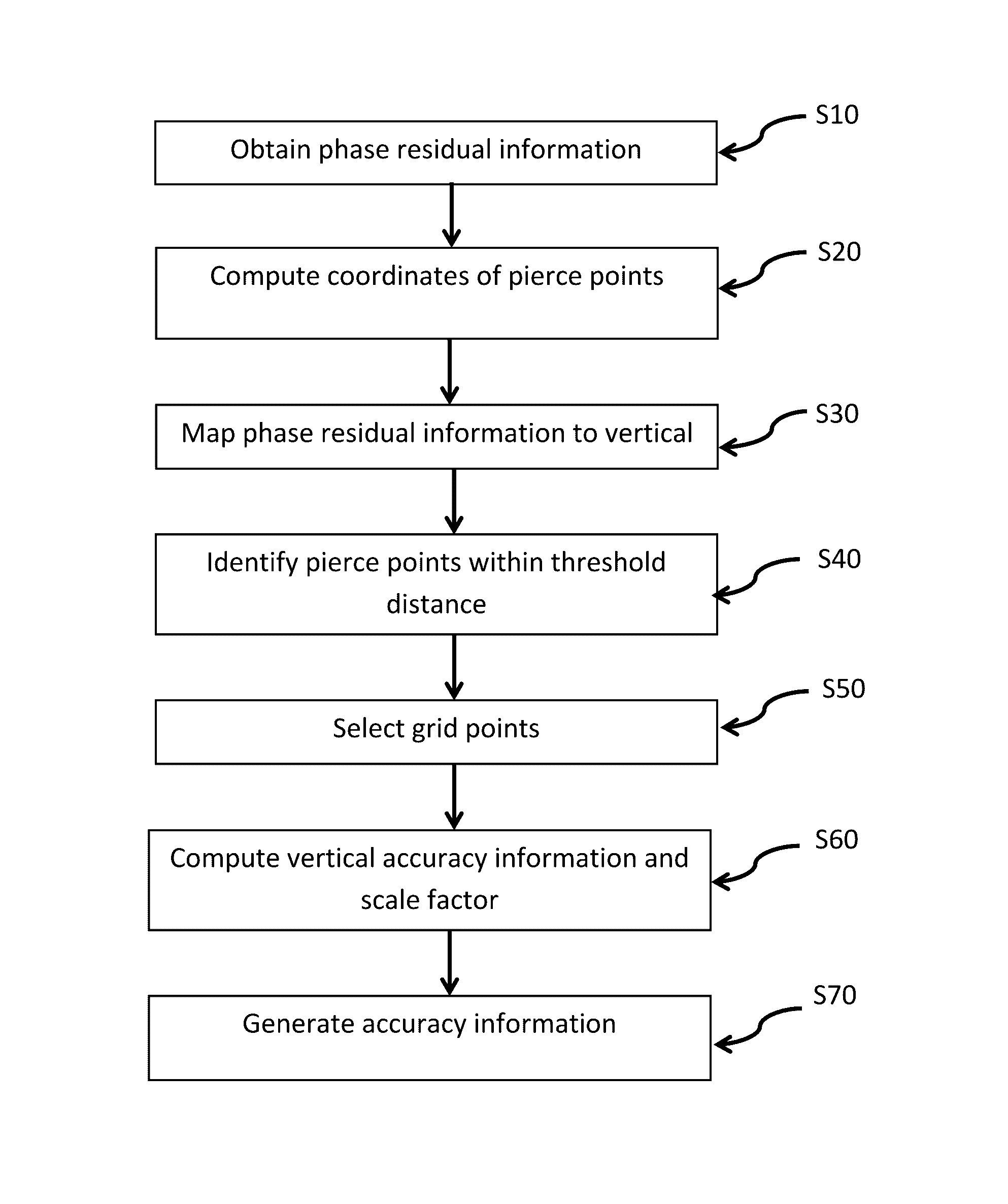
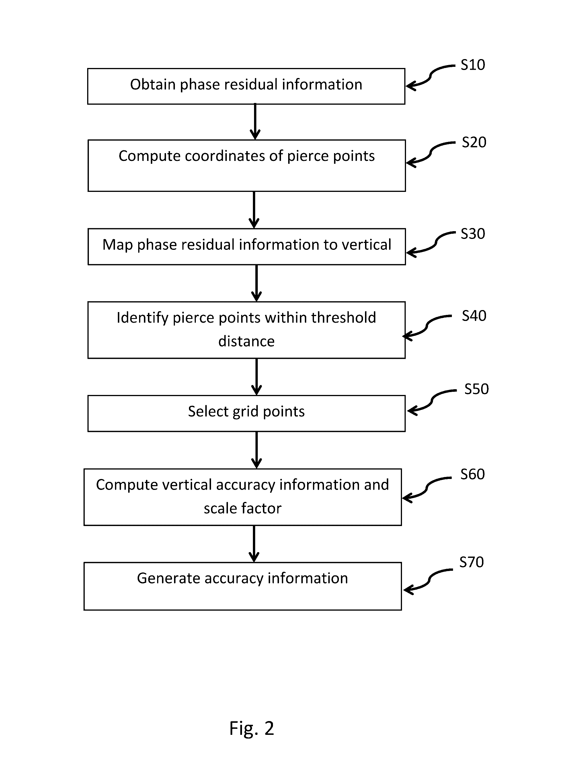
[0046]FIG. 2 is a flowchart of a method according to one embodiment of the present invention. The method is carried out by a computer or a set of computers. The method is used for generating accuracy information for an ionosphere model calculated using a parameter estimation procedure based on phase observations made using a plurality of ground stations. Each phase observation is obtained from at least two signals transmitted from a satellite to a ground station, each of the at least two signals having a different frequenc...


PUM


Abstract

Accuracy information for an ionosphere model is generated. Phase residual information of a parameter estimation procedure is obtained and coordinates of pierce points are computed on a sphere around the earth. The coordinates indicate where signals pierce the sphere. Phase residual information is mapped for each pierce point. A grid of equidistant points is put on the sphere and the pierce points are identified. For each selected grid point, vertical accuracy information is computed based on vertical residual information, and a scale factor is computed based on the vertical accuracy information. The accuracy information for the ionosphere model is generated based on the vertical accuracy information computed for the selected grid points and an overall scale factor computed based on computed scale factors.

Description

RELATED APPLICATIONS[0001]This application claims priority to U.S. Provisional Application No. 61 / 738,953, filed Dec. 18, 2012, the contents of which are incorporated herein by reference in their entirety for all purposes.TECHNICAL FIELD[0002]The invention relates to the field of satellite navigation systems. More particularly, the invention relates to methods and apparatus for processing satellite navigation observations in order to model the ionosphere, i.e. its effects on electromagnetic signals, and to generate accuracy information associated with an ionosphere model. The accuracy information may for example be used for satellite navigation applications, such as for example for precise point positioning.BACKGROUND[0003]Global Navigation Satellite Systems (GNSS) include for example the Global Positioning System (GPS), the GLONASS system, the Galileo system, the COMPASS system, and others.[0004]In the context of GPS for example, each satellite transmits continuously using two radi...

Claims


Application Information

Patent Timeline
Patent Type & Authority Patents(United States)
IPC IPC(8): G01S19/13G01S19/07
CPCG01S19/13G01S19/07G01S19/074
Inventor DRESCHER, RALFCHEN, XIAOMING
Owner TRIMBLE INC
Why Eureka
Try Eureka