Navigation system and method with location-aware accuracy and/or power adjustments

Active Publication Date: 2017-04-04
INTEL CORP
View PDF9 Cites 0 Cited by
  • Summary
  • Abstract
  • Description
  • Claims
  • Application Information

AI Technical Summary

Benefits of technology

The patent is about a navigation system that can estimate its own position and adjust its accuracy and power settings based on that information. It can also determine a navigation route based on the user's destination and the system's current position, and change the accuracy settings based on characteristics of the navigation route. This helps improve the accuracy of the navigation system and make it more user-friendly.

Problems solved by technology

Achieving desired accuracy with navigation systems has been an ongoing challenge.
The navigation data may include errors caused by various effects such as the effect of the atmosphere on the satellite signals, clock accuracy, and multipath errors caused by reflected satellite signals.
The resulting track determined for the receiver from this noisy position stream can vary erratically and may appear to jitter when displayed on a map grid (e.g., streets and highways) even though the user or vehicle carrying the receiver may be traveling in a straight line.
Although snapping the approximate receiver location to a map grid may improve user experience, problems may occur when the discrepancy between the estimated position and the actual absolute position of the receiver is substantial (i.e., as a result of lower accuracy).
When a user or vehicle approaches a waypoint, for example, and deviates from the established navigation route (e.g., takes a wrong turn), the lower accuracy may cause the system to have a substantial latency between the actual deviation from the route and the identification or detection of the deviation by the receiver.
In particular, the map application may assume that the deviation of the estimated position from the navigation route is a result of an inaccurate position measurement and thus snap the receiver location to the grid along the navigation route as if the receiver is following the navigation route.
The deviation may eventually be identified but the substantial delay in identifying the deviation caused by the lower accuracy often prevents the user or vehicle from making a correction in a timely manner, resulting in the calculation of a new navigation route or hindering the user experience.
Signal and data processing techniques that improve accuracy, however, may also increase power consumption in the navigation system receiver.
To operate with lower power consumption, which may be desirable in certain applications, may require a lower accuracy and may result in the problems identified above.

Method used


Image

  • Navigation system and method with location-aware accuracy and/or power adjustments
  • Navigation system and method with location-aware accuracy and/or power adjustments
  • Navigation system and method with location-aware accuracy and/or power adjustments

Examples


Embodiment Construction

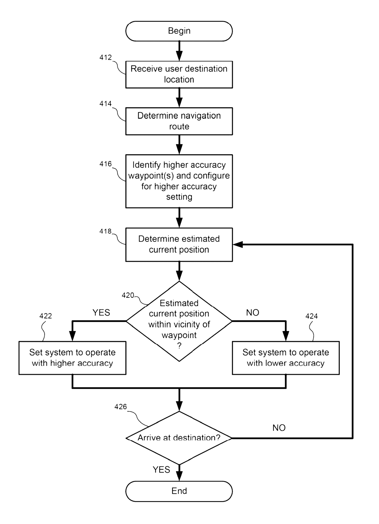
[0016]In a navigation system and method, consistent with embodiments of the present disclosure, location-aware adjustments may be made to the accuracy and / or power of the navigation system by changing at least one accuracy and / or power setting of a navigation system receiver in response to at least one characteristic of a navigation route and / or an estimated current position of the receiver. By providing location-aware accuracy and / or power adjustments, the accuracy may be increased when a higher accuracy is desired and may be decreased (with lower power) when a lower accuracy is sufficient based on the receiver location. A higher accuracy setting may be used, for example, when the estimated current position of a navigation system receiver is within the vicinity of a waypoint along the navigation route and a lower accuracy setting may be used at other times to reduce power consumption. Thus, power consumption may be improved with negligible impact on the accuracy and / or accuracy may...


PUM


Abstract

In a navigation system and method, location-aware adjustments may be made to the accuracy and / or power of the navigation system by changing at least one setting of a navigation system receiver in response to at least one characteristic of a navigation route and / or an estimated current position of the receiver. By providing location-aware adjustments, the accuracy may be increased when a higher accuracy is desired and may be decreased when a lower accuracy is sufficient based on the receiver location. A higher accuracy setting may be used, for example, when the estimated current position of a navigation system receiver is within the vicinity of a waypoint along the navigation route and a lower accuracy setting may be used at other times to reduce power consumption. Of course, many alternatives, variations, and modifications are possible without departing from this embodiment.

Description

FIELD[0001]The present disclosure relates to navigation systems and methods, and more particularly, relates to a navigation system and method with location-aware accuracy and / or power adjustments.BACKGROUND[0002]Navigation systems, such as satellite navigation systems, are commonly used by a variety of different users to determine a general location of the user, to determine a route to a destination location, and / or to navigate to that destination location. One example of a navigation system uses a global navigation satellite system (GNSS), such as the Global Positioning System (GPS), and receives satellite signals broadcast from multiple satellites. Navigation systems often include navigation system receivers carried by a user or a vehicle as the user or Vehicle moves. The navigation system receivers receive navigation signals, process the navigation signals to obtain navigation data (e.g., estimated positions of the receiver), and provide navigation data and / or navigation instruct...

Claims


Application Information

Patent Timeline
IPC IPC(8): G01C21/34G01S19/34G01S19/47G01S19/52G01S19/42
CPCG01C21/34G01S19/34G01S19/42G01S19/47G01S19/52
Inventor SEGEV, JONATHANRESHEF, EHUD
Owner INTEL CORP
Why Eureka
Try Eureka