System and method for planning travel way

A driving route and planning system technology, applied in the field of navigation technology, can solve problems such as congestion, more time spent, road interruption, etc., and achieve the effect of alleviating congestion and improving driving efficiency

Inactive Publication Date: 2007-10-31
MITAC COMP (SHUN DE) LTD +1
View PDF0 Cites 58 Cited by
  • Summary
  • Abstract
  • Description
  • Claims
  • Application Information

AI Technical Summary

Problems solved by technology

[0008] 3. Road interruption
However, the current road navigation equipment only considers the shortest path between the departure point and the destination while ignoring the traffic conditions when planning the driving route. On congested and impassable roads, it takes more time for users to reach their destination

Method used


Image

  • System and method for planning travel way
  • System and method for planning travel way
  • System and method for planning travel way

Examples


Embodiment Construction

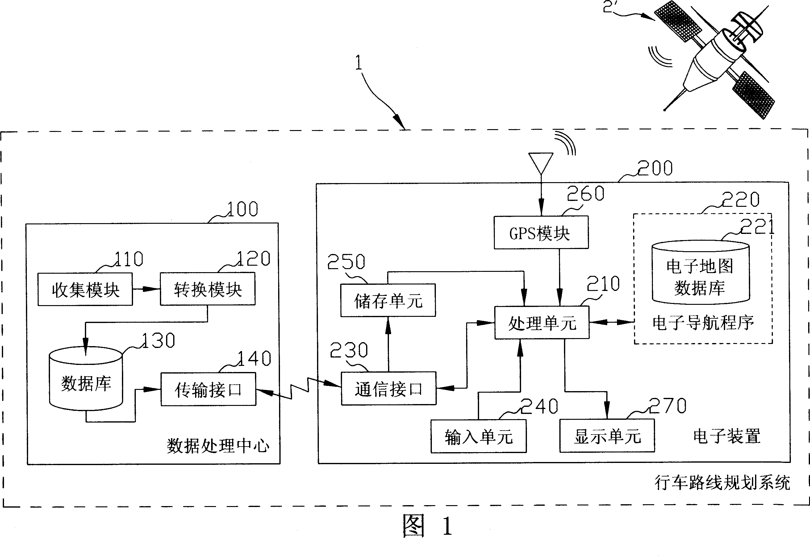
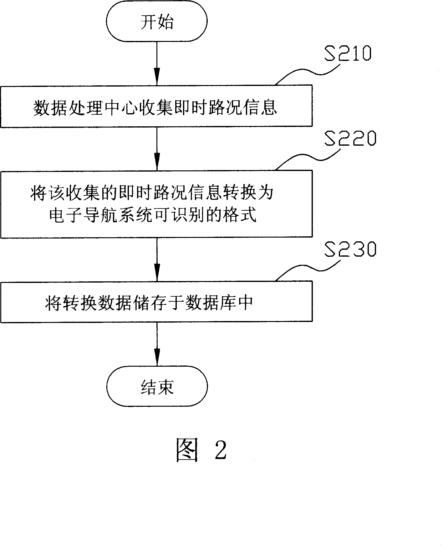
[0021] FIG. 1 is a block diagram showing the basic structure of the driving route planning system 1 of the present invention. As shown in the figure, the driving route planning system 1 of the present invention includes a data processing center 100 and at least one electronic device 200 (here only an electronic device 200 is taken as an example, that is, the present invention can also be applied to multiple electronic devices device). The electronic device 200 can be a personal digital assistant with GPS navigation function, and the electronic device 200 can also be a mobile phone, a smart phone, a car GPS (Global Positioning System, GPS) navigation device or a notebook computer, etc. device. The data processing center 100 is used to collect and store real-time road condition information, such as a server. The data processing center 100 at least has a collection module 110 , a transformation module 120 , a database 130 and a transmission interface 140 .

[0022] The collect...


PUM


Abstract

This invention discloses one car journey plan system and its method, which is applied in electron device with electron guidance program to make the device with path plan function, which comprises the following steps: establishing one data process center to collect and store the data; making the electron device execute electron guidance program for planned route; making the electron device get data process center information and to repeat the real situation information and plan route as re-planned router base.

Description

technical field [0001] The present invention relates to a navigation technology, in particular to a driving route planning system and method applied to an electronic device with electronic navigation function. Background technique [0002] The Global Positioning System (GPS) is an all-weather passive radio positioning system covering the whole world; the Global Positioning System is developed, operated and managed by the U.S. Department of Defense, and is used for aircraft and aircraft equipped with GPS receivers worldwide. Provides precise position, velocity, and time information for moving entities such as ships, warships, commercial ships, vehicles, and pedestrians. [0003] At present, most road navigation devices for vehicles have road positioning functions and road navigation functions. The road positioning function is to use the global satellite positioning system plus the inertial navigation device (orientation detector and vehicle speed detector) to calculate the l...

Claims


Application Information

Patent Timeline
Patent Type & Authority Applications(China)
IPC IPC(8): G01C21/26G01C21/34G08G1/0968G01S5/02G06Q10/00
Inventor 郑博玮
Owner MITAC COMP (SHUN DE) LTD
Why Eureka
Try Eureka