
Real time map-matching method and system based on relative coordinates positioning

A map matching and relative coordinate technology, applied in positioning, radio wave measurement systems, measurement devices, etc., can solve the problems of high network communication quality requirements, excessive network communication overhead, etc., to reduce communication frequency and network communication. The effect of quantitative and efficient real-time map matching function

Inactive Publication Date: 2007-12-05
瑞典维方达软件技术有限公司
View PDF0 Cites 20 Cited by
  • Summary
  • Abstract
  • Description
  • Claims
  • Application Information

AI Technical Summary

Problems solved by technology

[0005] In view of this, one of the purposes of the present invention is to provide a real-time map matching method based on relative coordinate positioning, through which the defects of excessive network communication overhead and high requirements on network communication quality in the prior art are solved

Method used


Image

  • Real time map-matching method and system based on relative coordinates positioning

Examples


Embodiment Construction

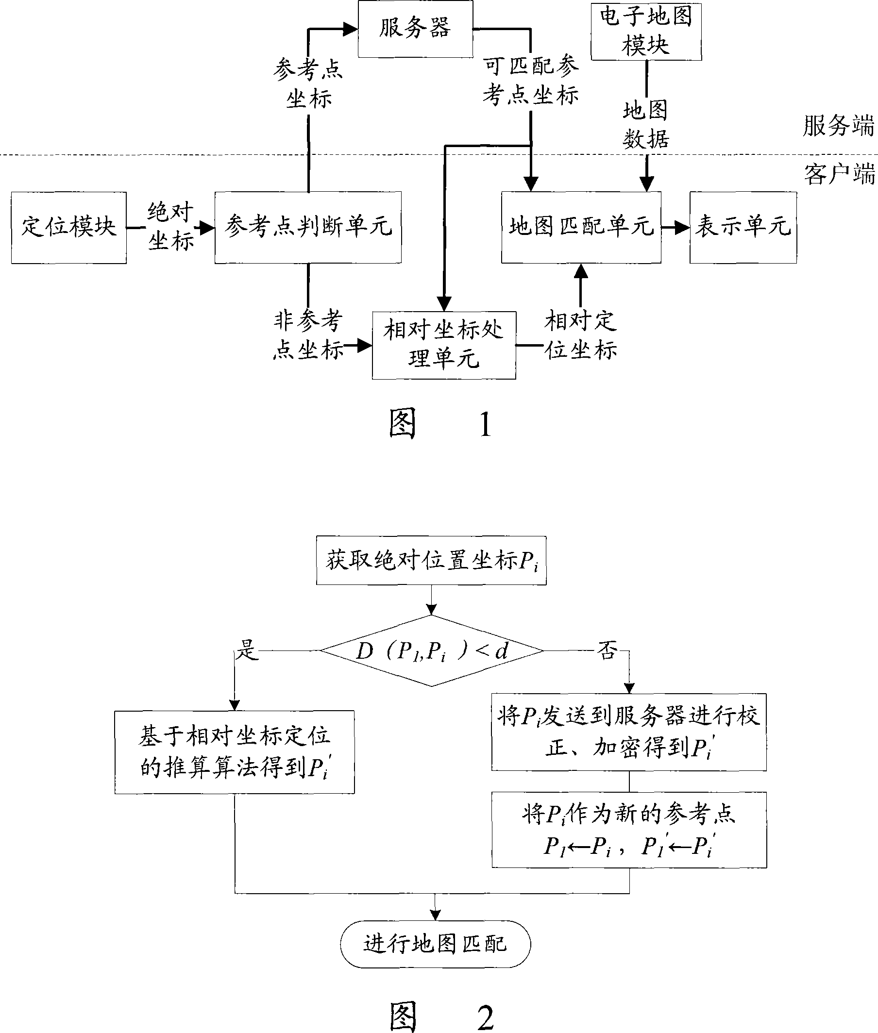
[0040] The present invention adopts the client / server interactive solution to realize real-time map matching, and the present invention does not limit the specific communication connection mode between the client and the server. As shown in Figure 1, a kind of real-time map matching system based on relative coordinate positioning according to the present invention includes the following main parts:

[0041] Positioning module: used to receive the geographic location information of the client, which can be a GPS receiver or a DR navigation sensing device, etc. The geographic location information includes geographic latitude and longitude, direction angle, driving speed and other information.

[0042] Reference point judging unit: used to receive the absolute position information sent by the positioning module, and distinguish between reference point coordinates and non-reference point coordinates according to reference point judgment rules.

[0043] Server: for receiving the re...


PUM


Abstract

This invention relates to the orientation / navigation technique field of the remove set, its aim is that it provides a sort of real-time map matching method and system which bases the relative coordinate orientation. It resolves the technical problem that the map data is insecurity and the traffic is high in the existing technique. Its realized project is that: Append a judgement unit of the reference point in the customer end which is used for dividing the absolute coordinates into the coordinate of the reference point and the coordinate of the non-reference point. For the coordinate of the reference point, the customer end sends it to the server and progresses emendation and / or encrypting disposal in order to create the coordinate of the reference point which can match. For the coordinate of the non-reference point, the relative fixed coordinate which is used for the map matching is calculated and obtained by the customer end according to a latest reference point and a reference point which can match. This invention depresses greatly the communication frequency between the customer end and the server, and reduces the network traffic. In the precondition that ensure the security of the encrypting arithmetic, it provides the function of the real-time map matching in the method of high efficient for the car orientation / navigation system.

Description

technical field [0001] The invention relates to the technical field of positioning / navigation of mobile devices, in particular to a real-time map matching method and system based on relative coordinate positioning. Background technique [0002] The development and application of GPS-based vehicle positioning / navigation system is being paid more and more attention at home and abroad, and shows huge economic and social benefits. Many vehicle positioning / navigation systems require accurate real-time map matching. Map matching is to compare and match the vehicle position and / or driving trajectory measured by GPS, Dead-Reckoning (DR, Dead-Reckoning) and other methods with the data in the on-board electronic map. Under the premise, the process of matching the output of the vehicle's GPS and / or DR with a large error to the corresponding point on the nearest road with a small error in the electronic map. It is not only beneficial to display the current position of the vehicle on t...

Claims


Application Information

Patent Timeline
IPC IPC(8): G01C21/30G01S5/02
Inventor 何丽娜
Owner 瑞典维方达软件技术有限公司
Learn More