Method and system for searching coordinates

A technology of coordinates and regions, applied in the field of coordinate search, can solve the problems of inability to perform navigation services, inefficiency, time-consuming map information search, etc., achieving the effect of less memory and system resources, improving design flexibility, and improving portability

Inactive Publication Date: 2009-05-27
MITAC COMP (SHUN DE) LTD
View PDF0 Cites 2 Cited by
  • Summary
  • Abstract
  • Description
  • Claims
  • Application Information

AI Technical Summary

Problems solved by technology

However, existing navigation software still cannot provide a map of the whole world, but is limited to specific regions, such as Taiwan, the United States or Japan. Therefore, after going abroad, the electronic device with GPS navigation function will be rendered useless
[0004] Furthermore, there is currently a communication software with a short message service location (Short message service location) on the market. The short message service location means that the sent or received short message contains map coordinates (that is, the latitude and longitude of the location). If it has a communication function Communication devices such as mobile phones or PDAs are also equipped with GPS modules, communication software and navigation software, so you can use SMS to send the current coordinates calculated by the GPS module, or receive SMS addresses sent from outside, the communication device After receiving the short message with the coordinates, the coordinates can be set as the destination or my favorite in the navigation software, and then the navigation software can be opened to provide navigation services. However, as mentioned above, when the navigation software When the provided map content does not have the information of the coordinates, the navigation service cannot be performed, and this is often found after the navigation software is turned on, and the information of the coordinates cannot be found in the map content, because the map of the navigation software The content occupies a large capacity, so a lot of user time has been wasted when confirming that the map information of this coordinate cannot be opened
[0005] Therefore, how to make the coordinates obtained by the GPS module find the corresponding map information in the navigation software more quickly, and can be commonly used in various regions, so as to improve the efficiency of searching map information for the coordinates, to solve the problem of time-consuming and useless searching for conventional map information. The problem of efficiency has become a problem that the industry needs to overcome urgently

Method used


Image

  • Method and system for searching coordinates
  • Method and system for searching coordinates
  • Method and system for searching coordinates

Examples


Embodiment Construction

[0013] The implementation of the present invention is described below through specific specific examples, and those skilled in the art can easily understand other advantages and effects of the present invention from the content disclosed in this specification. The present invention can also be implemented or applied through other different specific embodiments, and various modifications and changes can be made to the details in this specification based on different viewpoints and applications without departing from the spirit of the present invention.

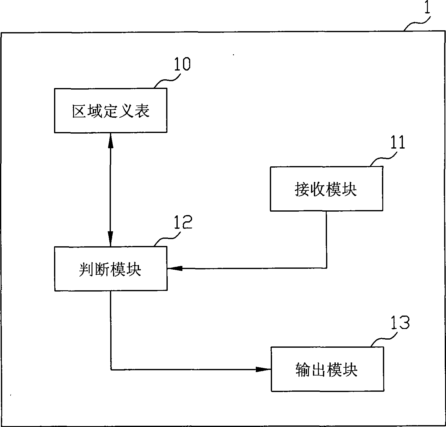
[0014] Such as figure 1 As shown, it is used to show a schematic block diagram of the basic structure of the coordinate search system implementing the present invention. As shown in the figure, the coordinate search system 1 of the present invention can be installed in a data processing device installed with GPS navigation software, or installed in a data processing device installed with SMS addressing software, and the data pr...


PUM


Abstract

The invention relates to a coordinate searching method and system, which are applied for data processing apparatus. The coordinate searching method and system establish a region define table for storing a plurality of region ranges, which correspond to a region code, in the data processing apparatus, make the data processing apparatus receive a coordinate obtained by a global positioning system (GPS), make the data processing apparatus determine whether the obtained coordinate accords with the region ranges stored in the region define table, and make the data processing apparatus output a corresponding signal according to determined result. So that, the coordinate searching method and system of the present invention can make the data processing apparatus not need to star GPS navigation software to search map as conventional search technology in operation of searching map by coordinate, thereby reducing occupied memory and system resource, and improving search efficiency.

Description

technical field [0001] The present invention relates to a coordinate search method and system. More specifically, the present invention relates to a coordinate search method and system that can be applied to a data processing device for searching maps by coordinates and can improve coordinate map search efficiency. Background technique [0002] Due to the vigorous development of Global Positioning System (GPS) technology, many electronic devices will have this GPS navigation function, such as electronic devices such as notebook computers, personal digital assistants (PDA) or mobile phones, through satellite and GPS finds the user's coordinates, and through the navigation software built in the electronic device, the user of the electronic device can obtain the shortest path between his location and the destination, thus effectively preventing the user from getting lost and detours road situation. [0003] Along with the GPS navigation function provided by electronic devices,...

Claims


Application Information

Patent Timeline
Patent Type & Authority Applications(China)
IPC IPC(8): G01C21/26G01C21/36G01S1/04G06F17/30
Inventor 郭光爵
Owner MITAC COMP (SHUN DE) LTD
Why Eureka
Try Eureka