Method for implementing satellite navigation positioning by different navigation frequency band

A satellite navigation and frequency band technology, applied in the field of satellite navigation, can solve problems such as being unsuitable for civilian use, and achieve the effects of short development cycle, low cost and simple solution

Active Publication Date: 2009-07-22
NAT ASTRONOMICAL OBSERVATORIES CHINESE ACAD OF SCI
View PDF1 Cites 15 Cited by
  • Summary
  • Abstract
  • Description
  • Claims
  • Application Information

AI Technical Summary

Problems solved by technology

but many of the technologies used in these ...

Method used


Image

  • Method for implementing satellite navigation positioning by different navigation frequency band
  • Method for implementing satellite navigation positioning by different navigation frequency band
  • Method for implementing satellite navigation positioning by different navigation frequency band

Examples


Embodiment Construction

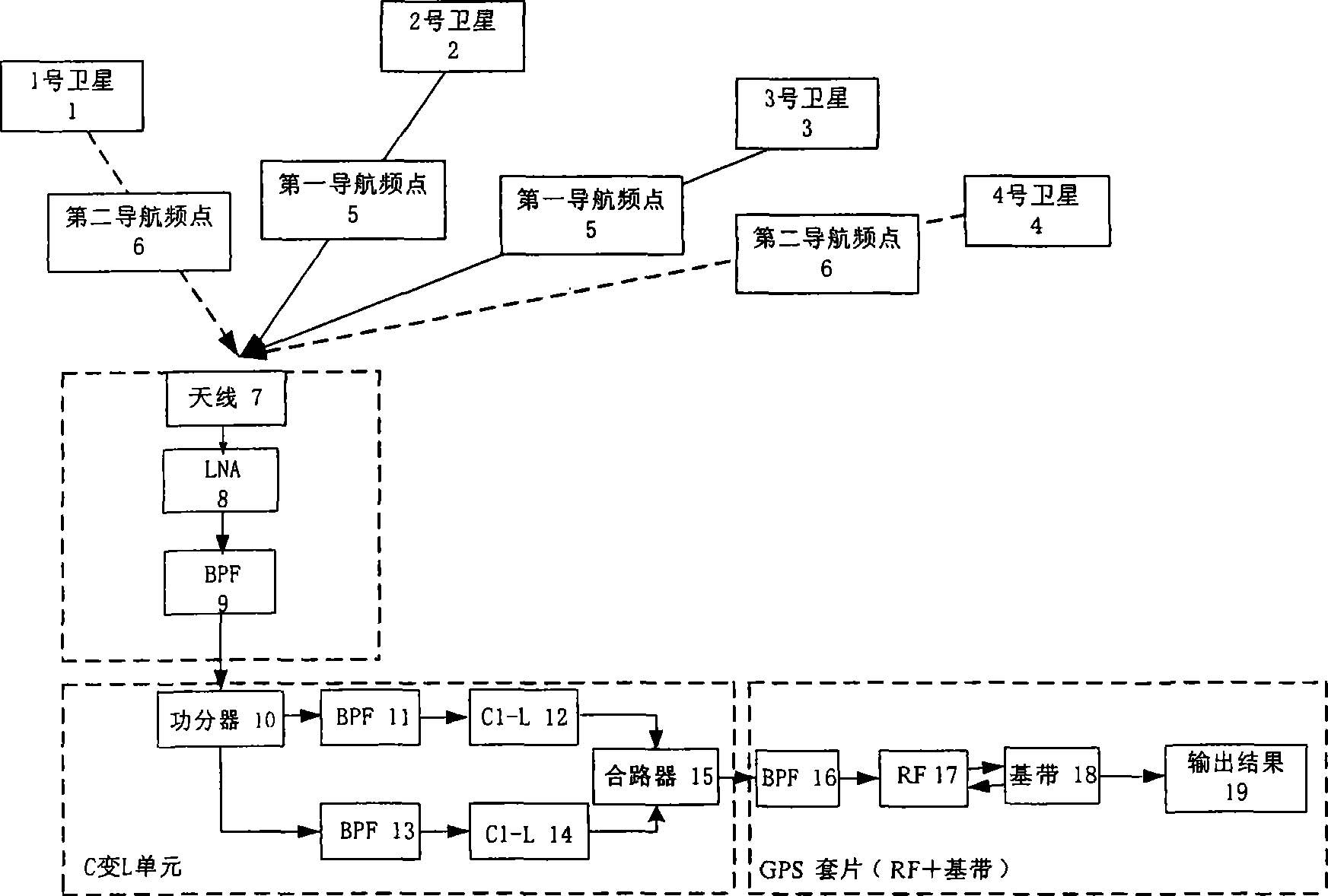
[0018] The present invention utilizes the present abundant communication satellites as navigation stars, rents transponders of different frequency bands of the communication satellites, the ground station transmits signals of different frequency bands and modulates different ranging codes, and the transponders forward the signals to the receiving terminal, thereby being used for navigation and positioning. To use the signals of these different frequency bands to complete navigation and positioning, the receiving terminal needs to do certain processing, that is, develop frequency conversion units of different frequency bands, measure the time delay of the signal after passing through these frequency conversion units, and use software to compensate; The cost, you can use the GPS chip.

[0019] A method of using different navigation frequency bands to realize satellite navigation and positioning, renting communication satellite transponders, the transponders can be in the same fr...


PUM


Abstract

The invention provides a method for realizing satellite navigation positioning by adopting different navigation frequency bands and relates to the satellite navigation technology. The existing communication satellite is rent for navigation positioning and no navigation satellite is launched specially. The rent satellite adopts different navigation frequency bands which are close to each other instead of the same navigation frequency band. As the selected navigation frequency bands are close, the same antenna containing all the navigation frequency bands can be used for ground receiving. GPS chips which are low in price, stable and reliable in the market are adopted in a navigation receiver, which lowers the manufacturing cost of a satellite receiver. As the GPS chips are designed directing at the frequency band of GPS, namely the L wave band, frequencies of navigation signals with different frequency bands are converted to the frequency band of the GPS by a frequency conversion unit, time delay caused by all frequency conversion units is measured and compensated by software and finally precise navigation positioning is realized by the GPS chips. By the method, anti-interference capability of a satellite navigation system can be improved greatly.

Description

technical field [0001] The invention relates to the technical field of satellite navigation, and relates to a method for realizing satellite navigation positioning by using different navigation frequency bands. Background technique [0002] The transponder satellite navigation system is a newly developed satellite navigation system, which can be referred to the invention patent (patent application number 200410046064.1), the signal is forwarded to the user through the leased 6 commercial geostationary orbit satellites and 3-4 inclined orbit satellites downlink ( At the current stage, no inclined orbit satellites have been launched, and the elevation constraint method is used to solve the three-dimensional positioning problem), so as to realize the user's navigation and positioning. When renting commercial satellites, according to the traditional concept of satellite navigation and positioning, it is necessary to rent transponders in the same frequency band, but this will lim...

Claims


Application Information

Patent Timeline
IPC IPC(8): G01S1/08
Inventor 孙希延艾国祥施浒立纪元法候雷王晓岚庞蜂宁春林
Owner NAT ASTRONOMICAL OBSERVATORIES CHINESE ACAD OF SCI
Why Eureka
Try Eureka