Mobile phone with navigation feature and positioning method thereof and corresponding system

A mobile phone and location information technology, which is applied in positioning, radio wave measurement system, service based on location information, etc., can solve the problems of high cost, long time required for positioning, unfavorable application of mobile phone users' rapid positioning scenarios, etc., and achieve reduction cost, speed-up effect

Inactive Publication Date: 2009-11-18
ZTE CORP
View PDF0 Cites 10 Cited by
  • Summary
  • Abstract
  • Description
  • Claims
  • Application Information

AI Technical Summary

Problems solved by technology

[0004] Above existing mobile phone location method, owing to all needing to receive by satellite signal, so cost is very high on the one hand (because receiving satellite signal needs to pay, and the receiving device cost of finishing satellite signal is high), on the other hand the time that positioning needs is relatively short. Long, which is not conducive to the application of mobile phone users who need to quickly locate the scene

Method used


Image

  • Mobile phone with navigation feature and positioning method thereof and corresponding system
  • Mobile phone with navigation feature and positioning method thereof and corresponding system
  • Mobile phone with navigation feature and positioning method thereof and corresponding system

Examples


Embodiment Construction

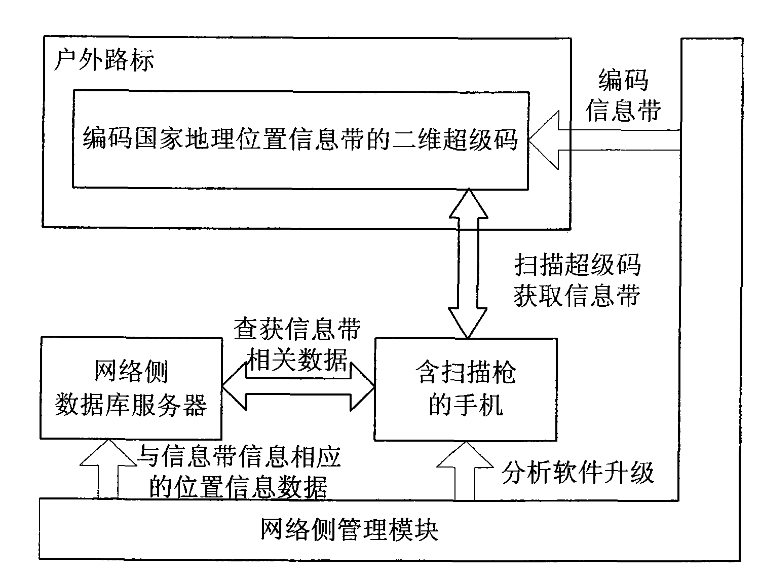
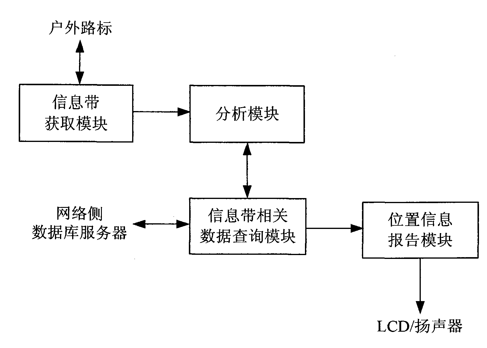
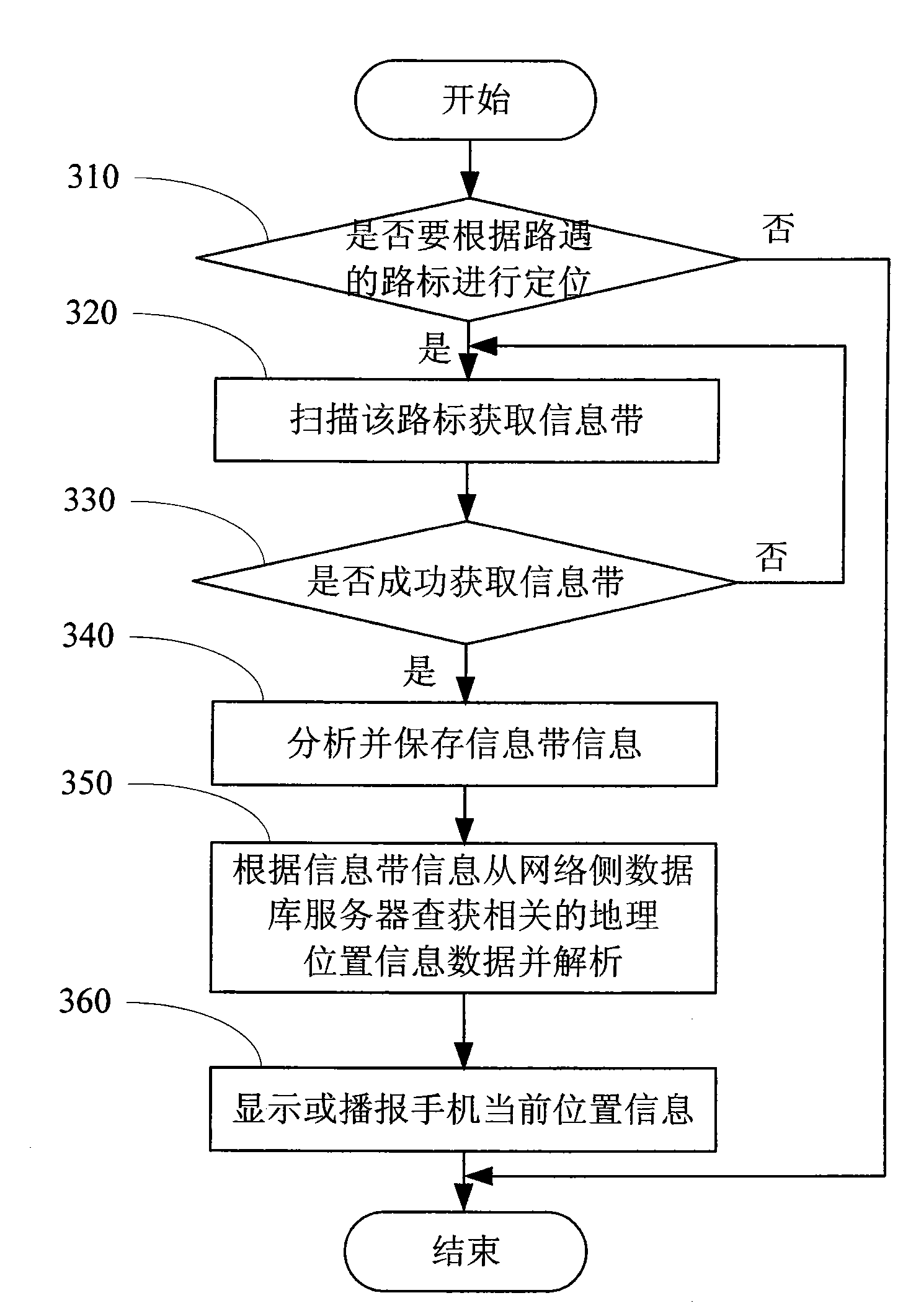
[0050] The mobile phone with navigation function and its positioning method and corresponding system of the present invention, its inventive idea is to use the scanning gun contained in the mobile phone to scan the two-dimensional super code of the coded national geographic location information belt carried on the outdoor road signs, Obtain the information belt information in the super code, search the corresponding location information data from the network side database server according to the information belt information, and display or broadcast the location information data to the user. Moreover, the two-dimensional super code of the coded national geographic location information band carried on the outdoor road sign can be updated at any time as needed.

[0051] The technical solution of the present invention will be described in detail below in conjunction with the accompanying drawings and preferred embodiments. The illustrated embodiments are only used to illustrate a...


PUM


Abstract

The invention discloses a mobile phone with navigation feature and a positioning method thereof and a corresponding system, and comprises an outdoor road sign, a mobile phone, a network side database server and a network side management module, wherein the outdoor road sign is loaded with the code of a national geographic information band; when the users need to carry out positioning by the outdoor road sign, the mobile phone obtains the code of the information band which is loaded on the road sign by scanning, and then obtains corresponding position information data from the network side database server according to the decoded and analyzed information of the information band, and later analyzes the position information from the position information data and displays and/or reports the position information to the users; and the network side management module carries out coding to the information band and makes the coding on the outdoor road sign, and then stores the position information data relating to the information of the information band in the network side database server. The invention does not need a satellite to achieve positioning, thereby lowering the cost and speeding up the positioning.

Description

technical field [0001] The invention relates to a wireless communication terminal, in particular to a mobile phone with a navigation function, a positioning method thereof and a corresponding system. Background technique [0002] The "two-dimensional code" widely used on mobile phones is a barcode that stores information in a two-dimensional space in the horizontal and vertical directions. It has the characteristics of strong error correction performance, ability to prevent distortion and strong anti-pollution ability. [0003] The existing positioning methods of mobile phones with navigation functions can be divided into two categories: one is "GPS positioning" and the other is "A-GPS" positioning. Among them, "GPS positioning" is based on the positioning of 24 satellites on the earth. It is generally used outdoors, that is, any GPS receiver (in the mobile phone) receives signals from more than 4 satellites, and can report GPS by calculation. The receiver's position (long...

Claims


Application Information

Patent Timeline
Patent Type & Authority Applications(China)
IPC IPC(8): H04W4/02G01S5/02H04W88/02
Inventor 李小莉伍长庆
Owner ZTE CORP
Why Eureka
Try Eureka