Method for processing navigation track of side scan sonar tow-fish based on navigation track line file

A side-scan sonar and track technology, applied in the field of sonar, can solve problems such as low efficiency and complicated operation, and achieve the effects of convenient implementation, reduced calculation amount, and simple and clear algorithm structure.

Inactive Publication Date: 2009-12-02
ZHEJIANG UNIV
View PDF0 Cites 12 Cited by
  • Summary
  • Abstract
  • Description
  • Claims
  • Application Information

AI Technical Summary

Problems solved by technology

[0008] The purpose of the present invention is to overcome the shortcomings of complicated calculation and low efficiency in the existing track processing method, and provide a side-scan sonar towing fish track processing method based on the track line file

Method used


Image

  • Method for processing navigation track of side scan sonar tow-fish based on navigation track line file
  • Method for processing navigation track of side scan sonar tow-fish based on navigation track line file
  • Method for processing navigation track of side scan sonar tow-fish based on navigation track line file

Examples


Embodiment

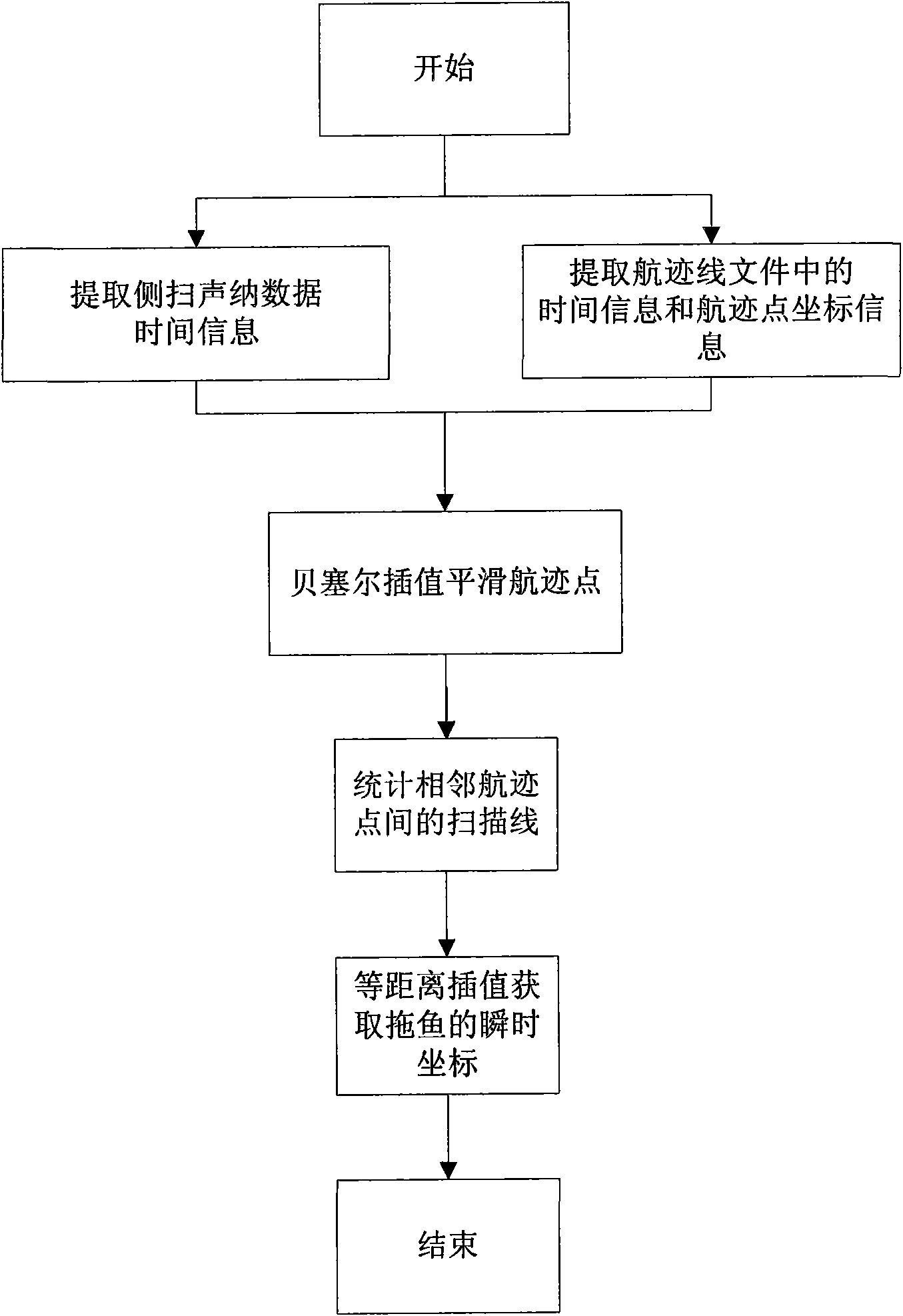
[0044] The first step is to analyze and compile the side-scan sonar data files: the existing sonar data mainly have two file formats, Qmips and XTF, and the present invention takes the XTF data format as the research object. The XTF file format is an extensible data format that stores sonar channel information, scanline attribute information, and scanline data in a binary format, which is very difficult to access directly. The side-scan sonar data file parsing class is written using an object-oriented method, and the side-scan sonar data file is packaged as an object to realize quick access to sonar channel information, scan line attribute information and scan line data.

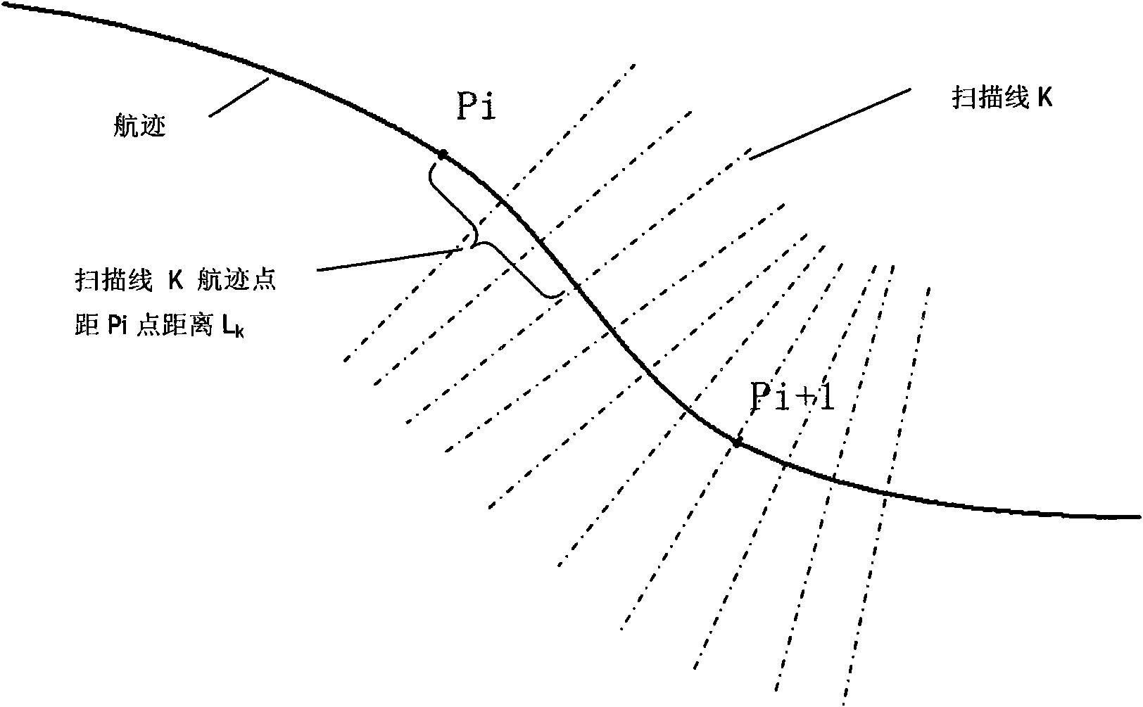
[0045] The second step is to sequentially read the records in the track file, and extract the time information and track coordinate points: when the side-scan sonar system is working, the relevant acquisition software will generate a track file, which consists of multiple Each record consists of four fields:...


PUM


Abstract

The invention discloses a method for processing navigation track of a side scan sonar tow-fish based on a navigation track line file, which comprises the following steps: firstly, extracting navigation track point coordinate information in the navigation track line file, adopting a Bessel's interpolation model to smoothly process the navigation track point coordinate information, fitting a practical navigation track of a tow-fish, then counting the number of the received scan lines when the tow-fish runs between adjacent navigation track coordinate points according to time information, and finally acquiring instantaneous coordinates when the tow-fish runs through equidistant interpolation. The method makes full use of the navigation track line file, simplifies the navigation track processing process, and effectively solves the problem of uneven scan line distribution due to unstable ship speed and asynchronous scanning and positioning. Simultaneously, the method can acquire good correcting effect on scan line intersection caused by the change of the progression direction of the tow-fish. The method for processing the navigation track of the sonar tow-fish can effectively eliminate various gaps generated during geographic coding of side scan sonar data so as to acquire clear and continuous submarine landform images.

Description

technical field [0001] The invention relates to the field of sonar, in particular to a side-scan sonar towing fish track processing method based on track line files. Background technique [0002] With the rapid development of science and technology and the gradual deepening of human understanding of the ocean, the ocean has been paid more and more attention to because of its huge economic potential and strategic importance. Side-scan sonar technology enables people to have more advanced technical means in the process of understanding the ocean and developing marine resources. Side-scan sonar technology combines acoustics, digital signal processing, navigation and positioning, and computer technology. It uses the principle of backscattering of incident acoustic waves by seabed features to detect seabed shapes and intuitively provide acoustic imaging of seabed landforms. Because of its high It is widely used in marine surveying and mapping, marine geological exploration, seab...

Claims


Application Information

Patent Timeline
Patent Type & Authority Applications(China)
IPC IPC(8): G01S7/52G01S15/89
Inventor 刘仁义刘南张丰尹天鹤黄克玲杜震洪
Owner ZHEJIANG UNIV
Why Eureka
Try Eureka