Data transmission sharing method of network topography system based on P2P

A technology of data transmission and terrain, which is applied in the direction of transmission system, data exchange details, and devices for branch offices to provide special services. , to achieve the effect of reducing the "short board" effect, improving the node hit rate and node matching rate, and reducing the "jitter" effect

Inactive Publication Date: 2009-12-30
WUHAN UNIV
View PDF0 Cites 9 Cited by
  • Summary
  • Abstract
  • Description
  • Claims
  • Application Information

AI Technical Summary

Problems solved by technology

[0006] The use of P2P for terrain data storage does not really solve the two problems in the previous centralized mode. Its purpose is to solve the problem of storage space, rather than solve the problem of data transmission and sharing; Consider the characteristics of the terrain system, such as tile heat problems (differences in heat in oceans, deserts, cities, etc.), node performance differences (differences between north and south operators, delay characteristics, online status), terrain roaming (translation operations, zoom operations) The characteristics of the problem lead to the inability to meet the requirements of node dynamics, and the P2P system is inherently dynamic, so it is difficult to meet the needs of practical applications
Currently, there is no practical P2P-based GIS terrain system

Method used


Image

  • Data transmission sharing method of network topography system based on P2P
  • Data transmission sharing method of network topography system based on P2P
  • Data transmission sharing method of network topography system based on P2P

Examples


Embodiment Construction

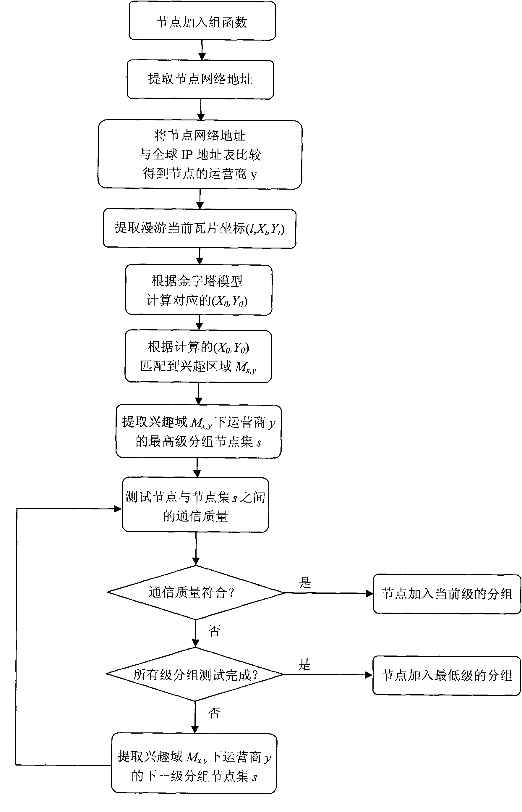
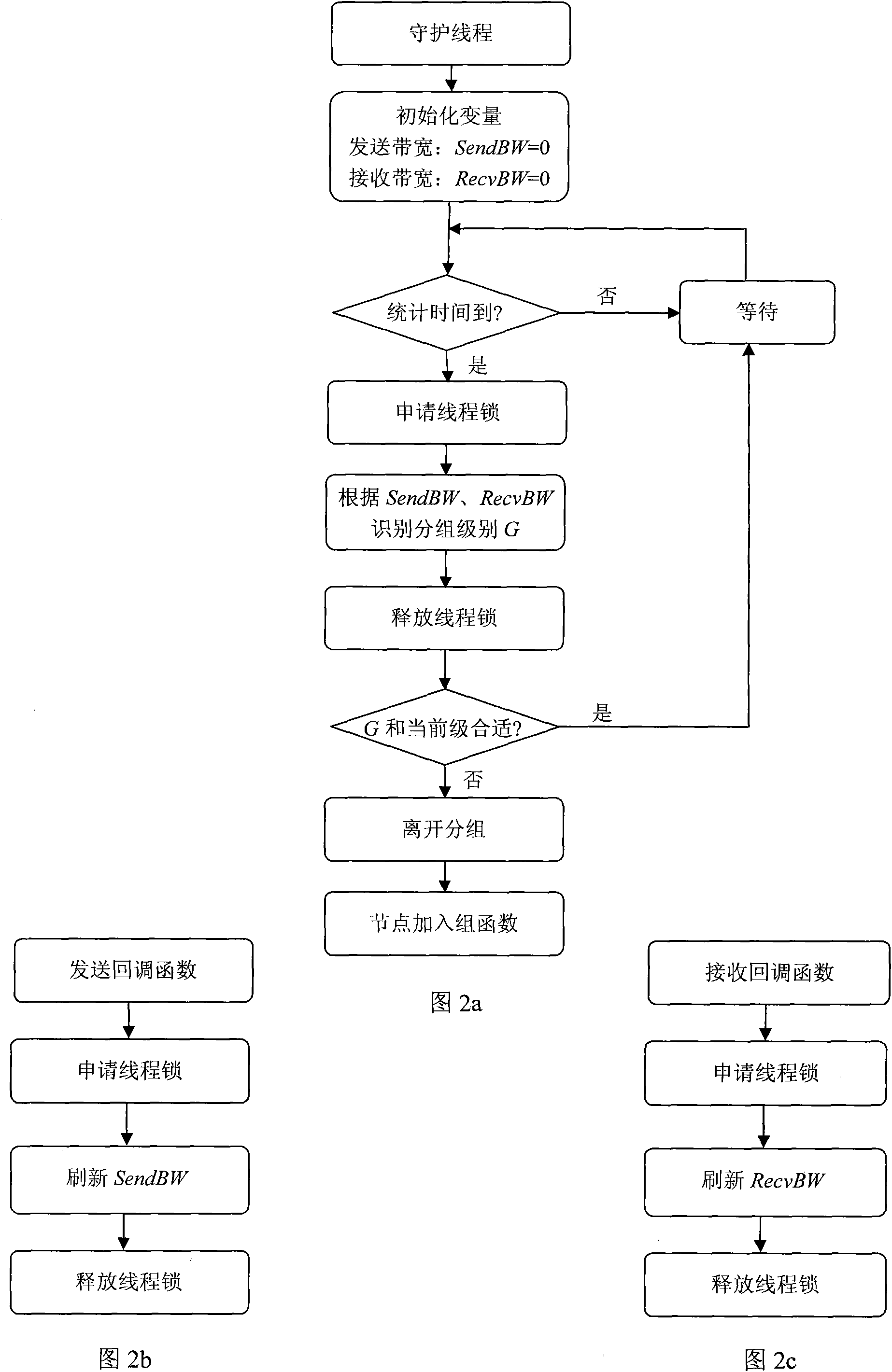
[0024]In the current terrain system, the image data is pre-generated in layers and blocks according to different scales to form a terrain tile pyramid model. When a user requests a tile, the terrain server does not need to generate data in real time, but according to the user's request For range and scale, the terrain server selects pre-generated images, stitches them into a range that meets the user's requirements, and returns them to the user. Therefore, the main performance bottleneck exists in transmission, so sharing through P2P is to reduce the bandwidth requirements of the terrain server one of the effective means. However, due to the huge number of terrain system tiles, such as SRTM90 with a resolution of 90 meters, there are a total of 3,538,890 tiles. If the tile information between nodes is exchanged according to the traditional mode, a large amount of additional bandwidth will be consumed; at the same time, due to the dynamic nature of P2P nodes As well as the perf...


PUM


Abstract

The invention relates to a data transmission sharing method of a network topography system based on P2P, which is implemented by classifying nodes more precisely by testing the features of the nodes, and balancing the sharing performance of each node in the group; using the division of the interest area to reduce the network bandwidth extra consumption consumed by interaction of cache mapping information; reducing the scale of the divided nodes by a primary agency and a secondary agency and reducing the frequent change of node grouping caused by the change of interest area to reduce shaking effect during sharing; using tile distribution calculation and node service capability calculation and fully using the idle network resource of the nodes, improving node hit ratio and node match ratio during tile request by fast and evenly distributing the tiles, reducing the rate of sharing failure, thus improving the sharing efficiency. The invention provides a spatial data transmission and sharing scheme featuring low cost, high performance, high utility and high expandability.

Description

technical field [0001] The invention relates to the technical field of network GIS data transmission, in particular to a data transmission and sharing method of a P2P-based network terrain system. Background technique [0002] Data transmission is a key technology in the network terrain system, which determines the sharing and transmission strategy of tile data in the terrain system, and directly affects the cost, load capacity and overall performance of the network GIS terrain system. [0003] The large-scale popularization and application of the current distributed virtual geographic environment is still limited by many practical conditions, including limited network bandwidth resources, massive spatial data information and domain information, huge user requests, and machine performance limitations. Relevant experts, scholars, scientific research institutes and enterprises at home and abroad have been committed to using existing resources to improve the capabilities of dis...

Claims


Application Information

Patent Timeline
Patent Type & Authority Applications(China)
IPC IPC(8): H04L29/08H04L12/18
CPCY02B60/31Y02D30/50
Inventor 潘少明李锐沈未名彭敏朱莉王浩
Owner WUHAN UNIV
Why Eureka
Try Eureka