Method for detecting remote sensing image change based on interest areas

A technology for regions of interest and remote sensing images, applied in the field of remote sensing image analysis and processing, to achieve the effects of avoiding false change information, improving accuracy, and accurate thresholds

Inactive Publication Date: 2010-04-14
XIDIAN UNIV
View PDF0 Cites 25 Cited by
  • Summary
  • Abstract
  • Description
  • Claims
  • Application Information

AI Technical Summary

Problems solved by technology

The disadvantage of this method is that there are many broken edges on the edge of the obtained change area, and many false edges of the change area are detected.

Method used


Image

  • Method for detecting remote sensing image change based on interest areas
  • Method for detecting remote sensing image change based on interest areas
  • Method for detecting remote sensing image change based on interest areas

Examples


Embodiment Construction

[0030] refer to figure 1 , the implementation of the present invention is as follows:

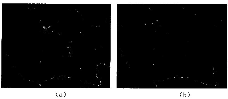
[0031] Step 1, input two remote sensing images of different time phases, such as figure 2 (a) and figure 2 As shown in (b), the filtering window size is 3×3 median filtering for two different time phases respectively, and two different time phase images after filtering are obtained.

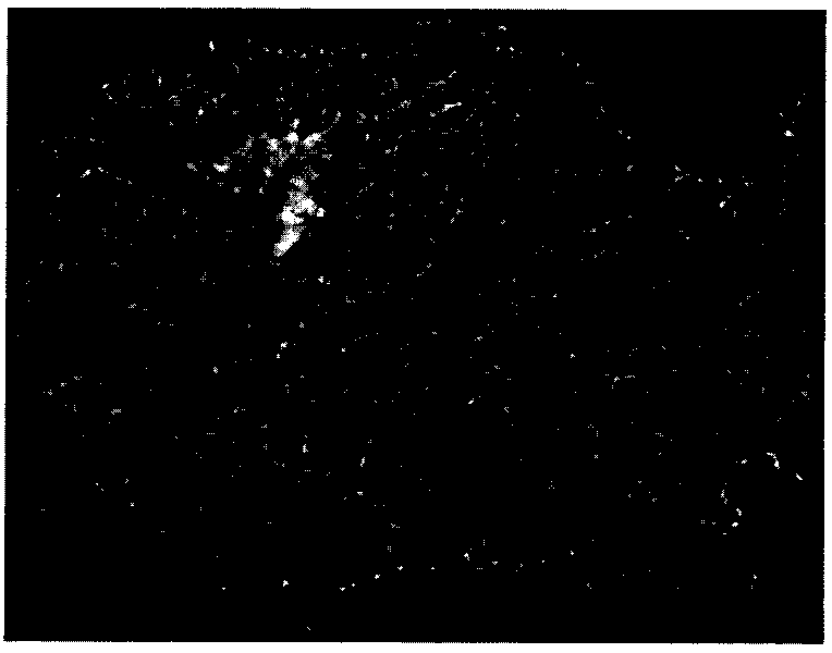
[0032] Step 2, calculate the gray level difference between the corresponding pixels of the two different phase images after median filtering, and obtain a difference image, such as image 3 shown.

[0033] Step 3, calculate the Canny edge of the difference map, and calculate the mean value feature of each edge point, and obtain an edge mean value map, the specific steps are as follows:

[0034] (3a) Use the Canny edge operator to operate the difference map to obtain a Canny edge map of the difference map, such as Figure 4 shown.

[0035] (3b) Taking each edge point in the Canny edge map of the differe...


PUM


Abstract

The invention discloses a method for detecting remote sensing image change based on interest areas, which belongs to the fields of analyzing and processing remote sensing images. The invention mainly solves the problems of pseudo-change information existing in the methods for detecting remote sensing image change, the implementation process comprises: firstly, extracting the outline of a differential chart, secondly, defining the outline map of a closed interest area based on the threshold value outline map chained method, and obtaining the interest area after expanding the outline, thirdly, obtaining a new differential chart through updating the differential chart according to the gray level, the space position and the sort feature of the interest area and a non-interest area, fourthly, dividing the interest area in the new differential chart, and obtaining a change result chart. The method has the advantages of accurate location of the interest area, noise and registration error robust, less pseudo-change information and high change detection, and can be used in the fields of disaster surveillance, land utilization and agriculture investigation.

Description

technical field [0001] The invention belongs to the technical field of image processing, in particular to a method for detecting changes in remote sensing images based on regions of interest, which is suitable for remote sensing image analysis and processing. Background technique [0002] The change detection of remote sensing images refers to detecting the change information of the ground features in the area over time by analyzing two or more remote sensing images from the same area at different times. With the development of remote sensing and information technology, change detection has been widely used in dynamic monitoring of forest resources, monitoring of changes in land cover and use, agricultural resource survey, urban planning layout, environmental monitoring and analysis, natural disaster assessment, and geographic data update. And many fields such as the dynamic monitoring of strategic targets such as roads, bridges, and airports in military reconnaissance. [...

Claims


Application Information

Patent Timeline
Patent Type & Authority Applications(China)
IPC IPC(8): G06T7/00G01S7/48
Inventor 王桂婷焦李成张凤玉公茂果侯彪刘芳钟桦马文萍
Owner XIDIAN UNIV
Why Eureka
Try Eureka